News   Apr 15, 2024
 948     0 
News   Apr 15, 2024
 2.1K     5 
News   Apr 15, 2024
 649     0 

TTC: Streetcar Network

I'm confused... where is the proposed streetcar loop we're talking about? Is there something I'm missing in the diagram above?

Are we talking about the lines around the "twenty second street" label? I thought those were just showing vehicle turning radii overlaid on the road layout.

That's why I'm asking for a better diagram. Looks like streetcar tracks, but could be turning specs for trucks, but why only to go eastbound?
 
Upon further investigation, as I was questioning what exactly would be accomplished by having a streetcar loop on the Humber College loop, this is a false alarm. There is no proposal for any such loop on site. Sorry @W. K. Lis
 
They could add a Kipling South streetcar route in its own right of way. Those busses are crowded and gets slowed down too much in traffic.
 
They could add a Kipling South streetcar route in its own right of way. Those busses are crowded and gets slowed down too much in traffic.
How many homes, business and underpass have to torn down to allow an ROW to be built and how far do you plan to take it north???
 
Kipling would be a tough sell compared to something that follows the 427 or uses the Hydro corridor and integrates with the Mississauga and 427 transitways.
 
They could add a Kipling South streetcar route in its own right of way. Those busses are crowded and gets slowed down too much in traffic.
Nah, the 44 is only crowded during student rushes and worker peak hours. On weekends, it is dead. A bus lane towards a few trouble spots will be significant.
 
Steve Munro reports...

From link.

King-Queen-Roncesvalles Update September 2020

The City of Toronto has issued an update for the project at the intersection of King, Queen, Roncesvalles and The Queensway.

King_Queen_Queensway_Roncesvalles_Ward4_Notice_Aug18

This is a complex piece of work with many components that will stretch into 2022 including:
  • Reconstruction of the bridge over Parkside Drive on The Queensway
  • Extension of the streetcar right-of-way east from its current end east of Parkside to Roncesvalles together with provision for left turns across the right-of-way at Glendale and at Sunnyside
  • Reconfiguration of the KQQR intersection (see my article from April 2020 for diagrams of the planned changes)
  • Replacement of old water main and sewer infrastructure
  • Replacement of TTC overhead (this will make the wiring in this area pantograph compliant)
  • Reconstruction of streetcar track
  • Reconfiguration of Roncesvalles Avenue from Queen to Harvard (just north of the North Gate to the carhouse) with cycling lanes and transit platforms matching the section done several years ago from Harvard to Dundas
  • Revision to the existing loading islands on Roncesvalles for compatibility with the boarding ramps on the news streetcars
The construction will begin on September 8, 2020 on the underside of the Parkside Drive bridge. This will only have a minor effect on transit service, and the only change to the 501 Queen service is that it will not stop at Parkside during September and October.

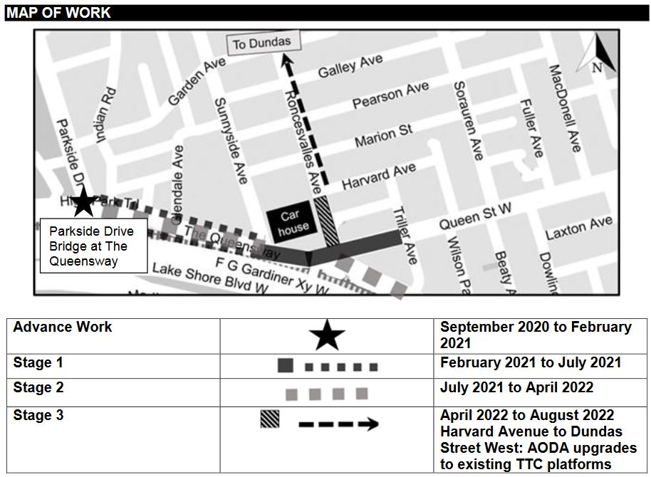
2021 will see the main construction work on Queen and The Queensway beginning in February and extending to into 2022 as shown in the staging map below.

Stage 1 from February to July 2021 will affect the curb lanes of The Queensway as well as water main, track and overhead work extending east to Triller Ave.

Stage 2 from July 2021 to April 2022 will affect the middle lanes of The Queensway and King Street south of the intersection.

Stage 3 from April to August 2022 will affect Roncesvalles Avenue.

See the construction notice linked above for details.

There is no word yet on the TTC’s arrangements for service or what the interim configurations of routes will look like. Continued access to Roncesvalles Carhouse via the North Gate will remain available until the planned work in 2022 at which point all access will have to shift to the south gate during construction between Queen and Harvard.

However, there will be periods where the KQQR intersection is impassible in both directions while it is reconfigured and rebuilt. This will require Queen and King services to turn back somewhere further east TBA with bus replacements.

It is not clear whether there will be a period in fall-winter 2021-22 when streetcar service can be restored west of the carhouse. I will pursue details of the project staging with the City and TTC.

kqqr_staging_map_aug2020.jpg
 
"Reconstruction of bridge over Parkside Drive"...

Why?
Because it's crumbling away and has exposed rebar; it clearly needs some TLC. The detailed TTC document call it "underside bridge rehabilitation work on Parkside Drive at The Queensway" so 'reconstruction' may be an exaggeration.
 
Last edited:
Because it's crumbling away and has exposed rebar; it clearly needs some TLC. The detailed TTC document call it "underside bridge rehabilitation work on Parkside Drive at The Queensway" so 'reconstruction' may be an exaggeration.

My point was, and this ties in to a topic discussed in another thread, is that there is absolutely no reason for the Queensway to be bridged over Parkside Drive. It should be a normal intersection at grade.
 
My point was, and this ties in to a topic discussed in another thread, is that there is absolutely no reason for the Queensway to be bridged over Parkside Drive. It should be a normal intersection at grade.

Interestingly the streetcar right of way on the Queensway, which used to be a high-quality ballasted track and without the slow orders at every intersection, was built in the mid 1950s as a high-speed surface route feeding into the streetcar subway planned for Queen Street. The grade separation at Parkside was part of that idea.

While I generally agree that the need for the grade separation isn't needed - its one of a very few TTC surface stops still completely inaccessible to some riders - I just suspect it'll be messed up too with long signals that make streetcar riders sit and wait.
 
Interesting article on BlogTO (yes yes, I know) (https://www.blogto.com/city/2014/03/what_the_toronto_streetcar_network_looked_like_in_1945/) today about the peak of streetcar routes in Toronto in 1945, including map: https://transittoronto.ca/archives/maps/Streetcar_1945.pdf

I wonder how many of the old routes would still be viable today?

Best way to flesh that out is look at the existing bus network and see what their numbers are like. Then look at the existing Streetcar routes and compare them to the quietest routes.

I do think the old routes that ran on Bloor and Yonge really should have been kept, and if put back in, might relieve some of the pressure off Yonge Subway.
 
Interesting article on BlogTO (yes yes, I know) (https://www.blogto.com/city/2014/03/what_the_toronto_streetcar_network_looked_like_in_1945/) today about the peak of streetcar routes in Toronto in 1945, including map: https://transittoronto.ca/archives/maps/Streetcar_1945.pdf

I wonder how many of the old routes would still be viable today?
I'm a big proponent of resurrecting the Parliament Streetcar or at the very least get the tracks to Castle Frank station. This would bring some operational symmetry to the network with 3 Streetcar terminals on each side of Yonge Street. I remember when I was attending George Brown a few years back, the TTC was replacing the tracks on Broadview so you had to take a shuttle bus from Broadview Station to Queen Street to get the 504. Had we still had tracks on Parliament up to Castle Frank, the TTC could have just moved the 504 and 505 there; like they do with the 510 and 511 when either Bathurst or Spadina is out of service.
 

Back
Top