News   Nov 27, 2024
 317     0 
News   Nov 27, 2024
 504     0 
News   Nov 26, 2024
 1.4K     1 

TTC: Streetcar Network

I imagine the wires were high enough that the trains would clear them. Not likely possible now with double stack and bilevel cars.

I was thinking of the rails, which are part of the streetcar power circuit. Since everything is electrically referenced to ground it normally might not matter, but railway signal and crossing circuits might be bothered. Having said that, I'm not fully clear how they function.
 
I was thinking of the rails, which are part of the streetcar power circuit. Since everything is electrically referenced to ground it normally might not matter, but railway signal and crossing circuits might be bothered. Having said that, I'm not fully clear how they function.

It's really not vastly different than, say, the current Davenport diamond - CN and CP use different circuit voltages and so the diamonds all need to be insulated from each other (and the rails around) in order to allow everything to work properly.

There is the added benefit, however, of the TTC tracks not needing isolation for circuitry, solely for power return. That means that what they likely did was ran a set of bus wires underneath the diamonds (and under the road) to link the rail on the two sides of the crossings, and the diamonds were likely electrically insulated from the rest of the trackwork.

Dan
 
Planned Changes to King, Queen, Roncesvalles and The Queensway for 2021

See link to Steve Munro's website.

This item was to have been approved by Council at its April 1, 2020 meeting, but that was cancelled. The item is still pending approval.

Toronto Council Infrastructure and Environment Committee recently approved the long-awaited changes at the intersection of King, Queen and Roncesvalles, and on The Queensway to occur in 2021. The detailed construction staging plan is not yet available, but the overall plans were part of the city’s report. This work had originally been planned a few years back, but was delayed for various reasons including conflicts with other projects and the desire to bundle all works affecting this area in one major undertaking.

The transit work includes extension of the “new” Roncesvalles street design south to include the stops just north of Queen, reconfiguration of the intersection between the four streets, and extension of the transit right-of-way on The Queensway from Claude (east of Parkside) east to Roncesvalles.

King-Queen-Roncesvalles-Queensway Intersection

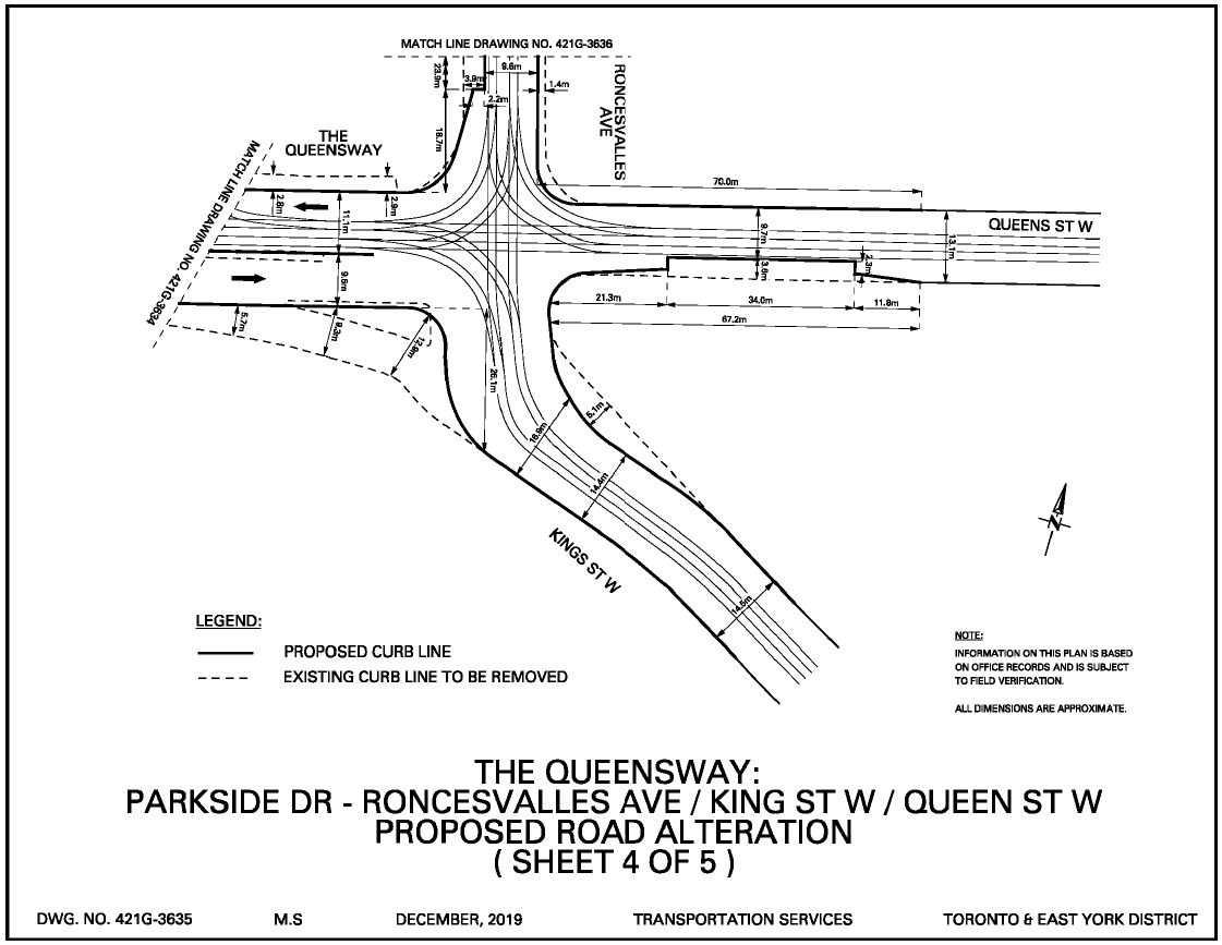
This intersection, which has been the subject of iconic photos in the TTC’s history, will be reconfigured as shown below. The biggest change is the realignment of the approach tracks from King Street so that they meet Queen Street in a conventional 90 degree configuration rather than the angled approach today. At the same time, the eastbound traffic channel that allows traffic to slip past the intersection onto King Street will be removed.

The eastbound carstop will be moved farside with a bump-out platform similar to those used on Roncesvalles Avenue.

The eastbound approach to the intersection will include four lanes: streetcars (reserved), left turns, through, and right turns. With the farside eastbound carstop, it is clear that the City is not anticipating a lot of through traffic. Traffic signals will be changed to use only two phases rather than the lengthy three-phase cycle now in place.

This arrangement greatly improves the safety for pedestrians crossing to and from the southwest corner of the intersection which provides access to the bridge over the Gardiner to Sunnyside Beach.

kqrq_2021_sheet4.jpg


Roncesvalles North of Queen

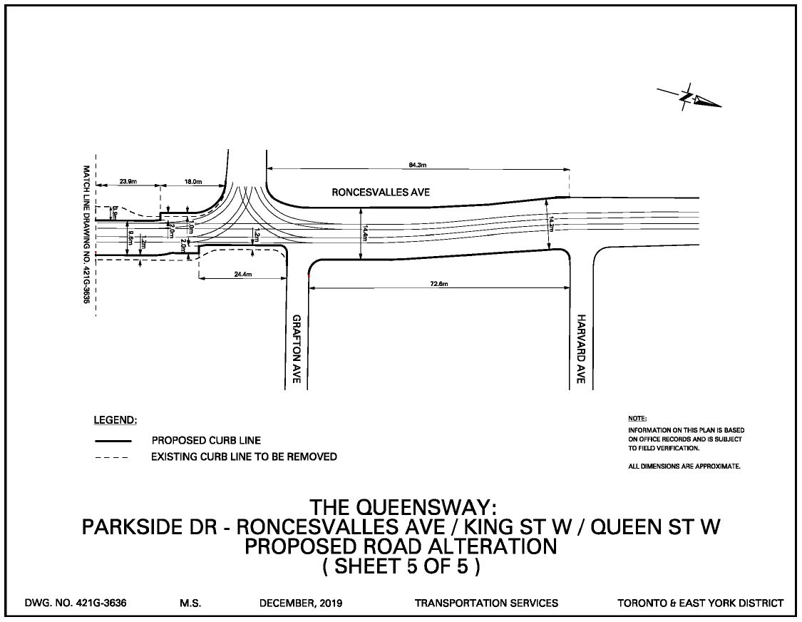
The stops north of Queen will be modified with bump-out curbs as on the rest of Roncesvalles north to Dundas so that there is direct loading from the sidewalk into the streetcars. The northbound stop will be shifted to Grafton Avenue rather than being just south of the entrance switch to the carhouse at it is today.

kqrq_2021_sheet5.jpg


The Queensway from Parkside to Sunnyside

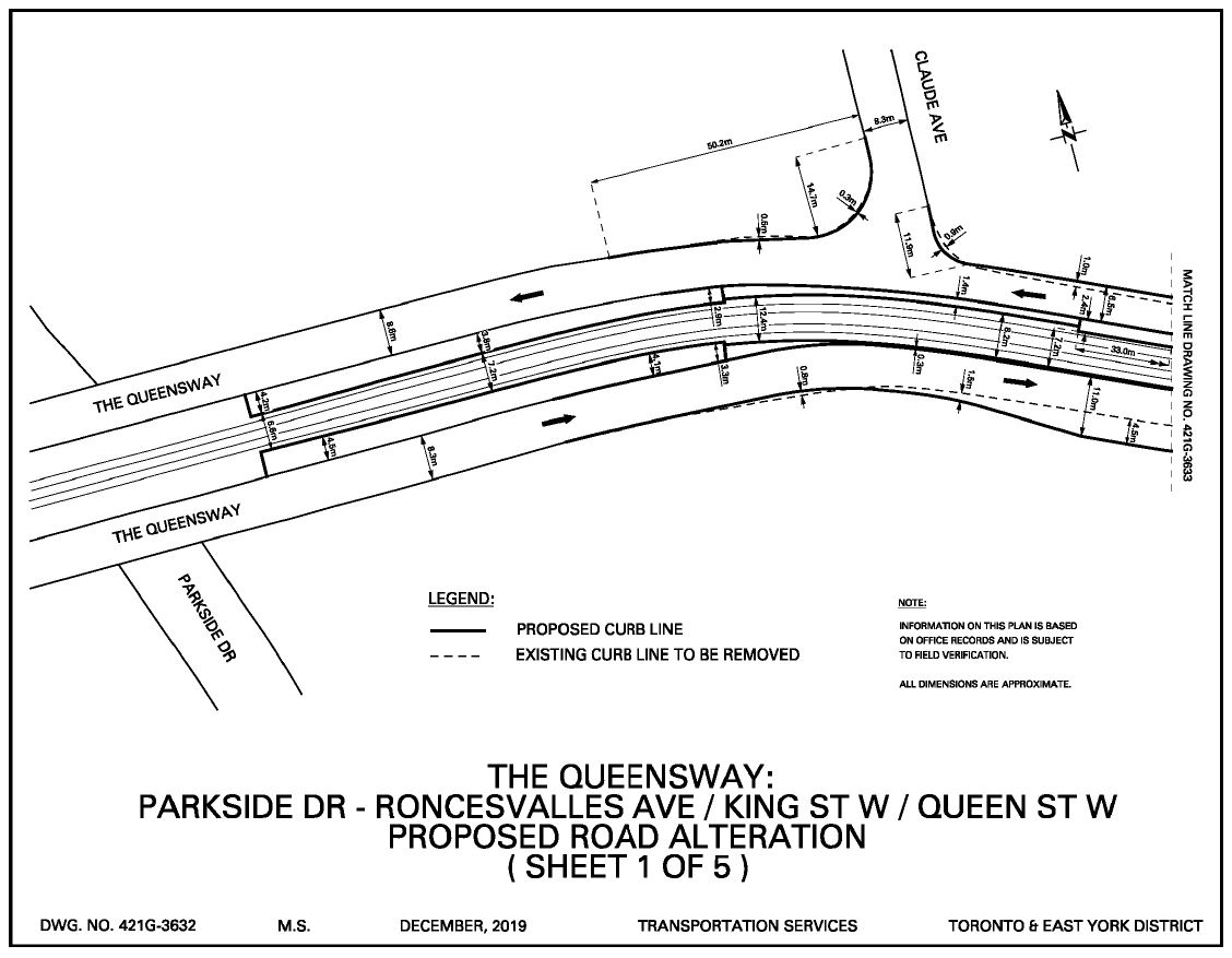
The right of way currently ends just west of Claude Avenue where streetcar and auto traffic merge. In the new design, the reserved lanes continue east on The Queensway, and it will no longer be possible to exit from Claude southbound to The Queensway eastbound. Northbound access is already barred by a turn restriction eastbound.

The bicycle lane on The Queensway eastbound that now becomes a sharrow just east of Parkside will be extended to Glendale Avenue.

kqrq_2021_sheet1.jpg


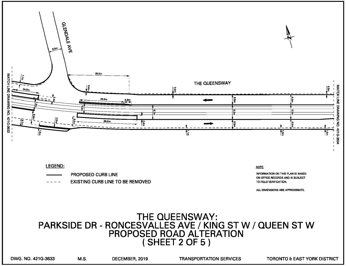
There will be a break in the right-of-way at Glendale to permit turns. This is the existing stop serving St. Joseph’s Hospital, but it will be changed so that the westbound stop is farside rather than nearside. The new stops will be designed to accessible standards.

A new left turn lane will be added eastbound at Glendale.

A short section of sidewalk will be added on the south side of The Queensway at the Glendale intersection, although it only spans the width of the intersection. This has always been difficult stop for TTC riders when buses replace streetcars because their waiting area is unpaved.

kqrq_2021_sheet2.jpg


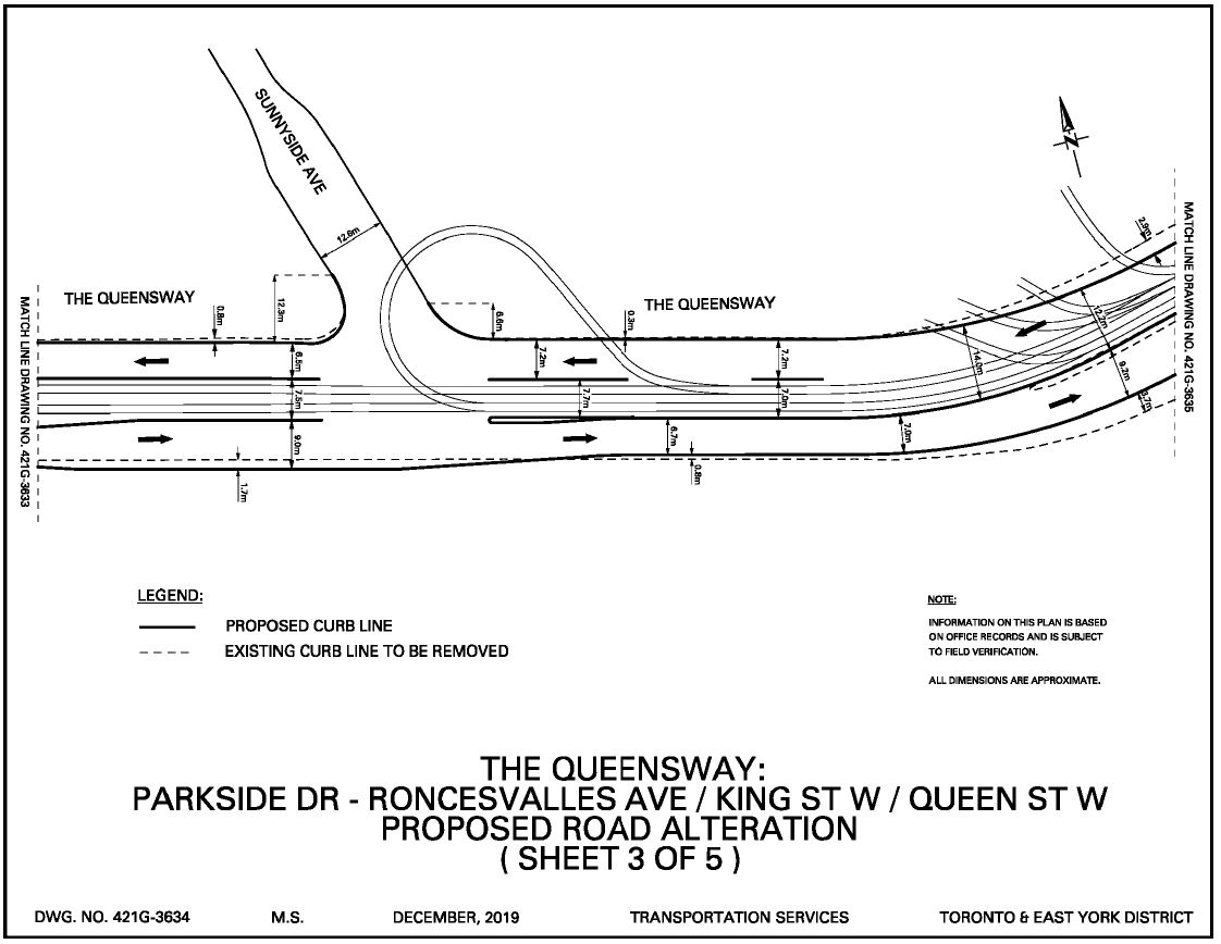
The right-of-way continues east toward Roncesvalles. The south side curb is continuous except at Sunnyside Avenue. The north side curb is open for much of the distance between Roncesvalles and Sunnyside because of the access tracks to the carhouse and to Sunnyside Loop.

Traffic signals will be added at Sunnyside Avenue to control movements across streetcar lanes, and to aid streetcars leaving the loop. A new left turn lane eastbound will be added.

kqrq_2021_sheet3.jpg
 
This may be a dumb question but why all the A and B route designations? I find it confusing when looking at the map and if I were not a regular rider, wouldn't know which one to take when downtown. Why not just separate numbers as I'm sure they do in Europe and elsewhere.
 
How would it not fit in?

The streetcar stops are shown to be located on Roncesvalles Avenue southbound (northwest corner), Roncesvalles Avenue northbound (northeast corner), Queen Street West eastbound (southeast corner), and Queen Street West westbound (northeast corner). That leaves the stop location for westbound 504B (going from King Street West to The Queensway), unless they use a separate stop on King Street West (southeast corner).
 
This may be a dumb question but why all the A and B route designations? I find it confusing when looking at the map and if I were not a regular rider, wouldn't know which one to take when downtown. Why not just separate numbers as I'm sure they do in Europe and elsewhere.
I am not sure it is more confusing to have, for example, 504A and 504B vs 504 and 514. Some transit systems seem to follow one convention, others another. The A & B folk obviously think of the "route' being the 504 with some vehicles running on the east and central part (in this case B) while others run on the western and central part. (or A). The bus routes often have far more 'branches' so the letters probably work better there and I guess the TTC liked having all modes handled the same way.
 
I am not sure it is more confusing to have, for example, 504A and 504B vs 504 and 514. Some transit systems seem to follow one convention, others another. The A & B folk obviously think of the "route' being the 504 with some vehicles running on the east and central part (in this case B) while others run on the western and central part. (or A). The bus routes often have far more 'branches' so the letters probably work better there and I guess the TTC liked having all modes handled the same way.

One other thing to consider.....

There will likely be periods of operation - perhaps early in the morning on weekends, late evenings all week, etc. - where the routes will be combined so that all vehicles travel the full distance of both routes.

In this case, appending a letter to the base route designation for the different branches may be the simplest thing for everyone to remember, rather than trying to figure out which route is which and at which times.

Dan
 
Planned Changes to King, Queen, Roncesvalles and The Queensway for 2021

See link to Steve Munro's website.

This item was to have been approved by Council at its April 1, 2020 meeting, but that was cancelled. The item is still pending approval.


kqrq_2021_sheet4.jpg


kqrq_2021_sheet5.jpg


kqrq_2021_sheet1.jpg


kqrq_2021_sheet2.jpg


kqrq_2021_sheet3.jpg

Turning now to the traffic lane widths for The Queensway. Are they designed for the “suggested” speed limit of 50 km/h, the old "designed" 60 km/h, or for the “safety” of speeders doing 100+ km/h? Motorists would slow down if the traffic lanes were actually narrow.

By narrowing the traffic lanes to force the traffic to slow down, they could leave room for a raised bicycle lane in each direction. Hopefully at The Queensway and King Street West intersection they will leave some space for raised bicycle lanes, including access to the possible Roncesvalles Avenue south extension bridge for cyclists and pedestrians only (was planned back in 2007, then Rob Ford came along and ended that.)
 
I'm just curious on how many routes are pantograph ready and how many aren't.

501 - incomplete except for some sections that allow cars heading into service on 509, 510, 511 and 512 from Lesly barns

503 - Maybe but hasn't seen streetcars for awhile

504 - parts may be useable for one half of the route like from Broadview to Dufferin loop, distillery lop section is usable but all of the routes isn't complete until the king, queen and Roncesvalles section is redone

505 - mostly complete possibly done at this point and fully usable for pans

506 - still work to be done

508 - incomplete for the same reason as queen and part of king

509 fully competed and pans are in use on

510 - fully completed and pans are in use on

511 - fully completed and pans were used until replacement by buses

512 - fully complete and pans in use

505 is pan to Parialment, pole Parialment to Broadview Stn
 

Back
Top