News   Nov 22, 2024
 705     1 
News   Nov 22, 2024
 1.2K     5 
News   Nov 22, 2024
 3.3K     8 

Roads: Six Points Interchange Reconfiguration (City of Toronto, UC)

And, it was foward thinking. No longer will people have to drive across 1950s bridges and interchanges everyday, instead, Six Points gets the at-grade treatment to make roads in the area safer. It is great the City thought of this, why it couldn't be done years ago is beyond me...

In the 1950's and 1960's, the thinking was that bridges, underpasses, cloverleafs, and automobile right-of-ways (without sidewalks) were the way of the "future". Unfortunately, we still have politicians, bureaucrats, and civilians who are stuck in that era today.
 
In the 1950's and 1960's, the thinking was that bridges, underpasses, cloverleafs, and automobile right-of-ways (without sidewalks) were the way of the "future". Unfortunately, we still have politicians, bureaucrats, and civilians who are stuck in that era today.

Many, many. many politicians are stuck, notably ones from suburban areas where these types of interchanges are common. Ford is a real big offense to this forum. This forum and Ford don't consisde with each other, nor should they.

Let's hope Dundas/Royal York, Islingon/Rexdale and Weston/Albion are next.

I hope so. All of these are interchanges where cars and trucks go high speed to turn on and off main roads. At grade intersections are way safer for pedestrians, and even automobiles as well.
 
It is great the City thought of this, why it couldn't be done years ago is beyond me...

Well, because only more recently the focus shifted to a) creating a vibrant city centre in the zone and b) agreeing that it was worth the pain of downgrading the through traffic flow and c) extracting the maximum amount of sellable city land for development.

There have been past proposals for development in that zone, including a courthouse, and a TTC yard. Happily, they didn't come to much, because they would likely have left the streets pretty much as is, rendering the area a pretty sprawly, unwalkable, unattractive zone.... but one with great roads.

While it may be unpopular to say this, Six Points was a very effective layout for moving cars. It did so, however, at the expense of any other potential use of the area. The new area may turn out to be quite lovely, but I doubt it will be anywhere near as good for the automobile. That's a tradeoff that wouldn't have been acceptable, let alone popular, even ten years ago. I still wonder how they got this plan by RoFo.

- Paul

PS - re taking photos - it's probably too late, because the whole area is so dug up by now, but yeah I was planning on taking some night shots and time exposures this week, before the bridges close. Is there an official time and date when the barricades go up? My oldest memory of moving to Etobicoke as a child involves the construction to build the "cloverleaf", so I feel like a ceremony is in order. No tears, just a "sic transit transit" kind of thing.
 
I thought @Jasonzed had taken some video last year but I checked his YouTube page and didn't see it. Perhaps it was posted on his Drone Activity thread in the Photos section of UT.

For me, It will feel weird driving through that area now. Up until 2016, I had driven through the area on an almost daily basis for thirty years. Huge changes in that part of the city.
 
Wasn't Royal York and Dundas changed from at-grade to interchange in response to many accidents?

There was a history of accidents, yes, in part due to having an at grade intersection with a railway crossing close to it..... but more because of the growth in volume of traffic as central Etobicoke developed.

I would challege anyone to suggest how that intersection could have been designed in any other way. It is actually extremely functional. I walk it several times a week, and in the context of a not very appealing streetscape on Dundas, existing condos on Royal York that are deliberately disconnected from the street, and new construction around Prince Edward that was approved with little concern for or insistence on a walkable street environment, the RY-Dundas intersection is neither a llimiting nor enabling factor in improving this area.

I bristle a bit at people suggesting that these road layouts should be rebuilt just because they hark from years when the auto was king. This does sound like “war on the car” thinking with no agenda other than to stick it to motorists “ just because”. Outside of the city core, the entire GTA was built to be auto centric. We can’t simply tear it up. We need to make constructive improvements, and that will lead to suburban zones that downplay autos. But constricting auto traffic in the suburbs should not be an end in itself. There is nothing wrong with accommodating the current reliance on the automobile provided it does not prevent promotion of transit or active modes.

Six Points is a good move because the overall zone plan is worth the change, but RY/Dundas, Rexdale/Islington etc are just fine - until someone has a plan for those areas as well.

- Paul
 
Last edited:
I shot a few videos today, but the Drone folks need to a full 360 view of the whole area both as photos and videos. Will post what I shot in the coming days once Bell shows up to fix the Internet and Fibe TV that hasn't work since Thursday.

Dunbloor is a skating rink with snow that need to be plow and sanded this coming week for Feb 24 opening date. Construction traffic light in place at Bloor and Dunbloor, with fix centre light on Dunbloor and the new Dundas.

No idea if there is a sidewalk west of the driveway for the condo, as it pure snow and ice there now.
 
There was a history of accidents, yes, in part due to having an at grade intersection with a railway crossing close to it..... but more because of the growth in volume of traffic as central Etobicoke developed.

I would challege anyone to suggest how that intersection could have been designed in any other way. It is actually extremely functional. I walk it several times a week, and in the context of a not very appealing streetscape on Dundas, existing condos on Royal York that are deliberately disconnected from the street, and new construction around Prince Edward that was approved with little concern for or insistence on a walkable street environment, the RY-Dundas intersection is neither a llimiting nor enabling factor in improving this area.

I bristle a bit at people suggesting that these road layouts should be rebuilt just because they hark from years when the auto was king. This does sound like “war on the car” thinking with no agenda other than to stick it to motorists “ just because”. Outside of the city core, the entire GTA was built to be auto centric. We can’t simply tear it up. We need to make constructive improvements, and that will lead to suburban zones that downplay autos. But constricting auto traffic in the suburbs should not be an end in itself. There is nothing wrong with accommodating the current reliance on the automobile provided it does not prevent promotion of transit or active modes.

Six Points is a good move because the overall zone plan is worth the change, but RY/Dundas, Rexdale/Islington etc are just fine - until someone has a plan for those areas as well.

- Paul


Yes, and any road diet needs to be accompanied by substantial transit improvements in a given area.
 
I shot a few videos today, but the Drone folks need to a full 360 view of the whole area both as photos and videos. Will post what I shot in the coming days once Bell shows up to fix the Internet and Fibe TV that hasn't work since Thursday.

Dunbloor is a skating rink with snow that need to be plow and sanded this coming week for Feb 24 opening date. Construction traffic light in place at Bloor and Dunbloor, with fix centre light on Dunbloor and the new Dundas.

No idea if there is a sidewalk west of the driveway for the condo, as it pure snow and ice there now.

This calls for drones!

Yes, and any road diet needs to be accompanied by substantial transit improvements in a given area.

There defentily hasn't really been any transit improvements in Six Points area, although there is the Metrolinx Hub opening up fairly soon down the street at Kipling Station. That will obviously be the "substantial transit improvements" here.
 
Wasn't Royal York and Dundas changed from at-grade to interchange in response to many accidents?

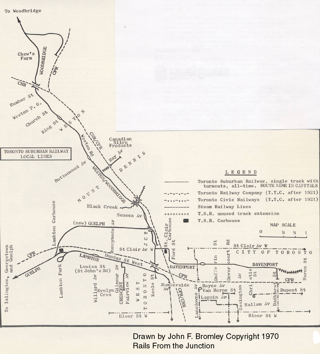
That hydro line corridor we see today at Royal York & Dundas, used to be the route of the Guelph Toronto Suburban Radial Railway.
map_tsr.jpg

From link.

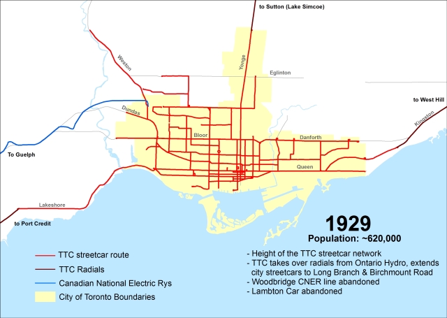
That lasted until 1931. From link.
ttc-streetcars-19291.jpg
 
Wow, did Toronto really have a streetcar running on Yonge to Simcoe? What were the frequencies like?
 
Wow, did Toronto really have a streetcar running on Yonge to Simcoe? What were the frequencies like?
Good question. I don't think it's as long as the line to Guelph, and that ran every couple of hours, I recall from old schedules.

There's a Wikipedia page on the line - https://en.wikipedia.org/wiki/Metropolitan_Street_Railway_(Toronto). It includes an old map showing the running time was 2 hours 40 minutes from the CP tracks.

Here's a better copy of the image from the Toronto Archives through the Transit Toronto site - https://transit.toronto.on.ca/streetcar/4132.shtml. I can't find a timetable quickly though.

174111
 
Last edited:

Back
Top