News   Jul 16, 2024
 343     0 
News   Jul 16, 2024
 453     2 
News   Jul 15, 2024
 1.2K     3 

Transit Fantasy Maps

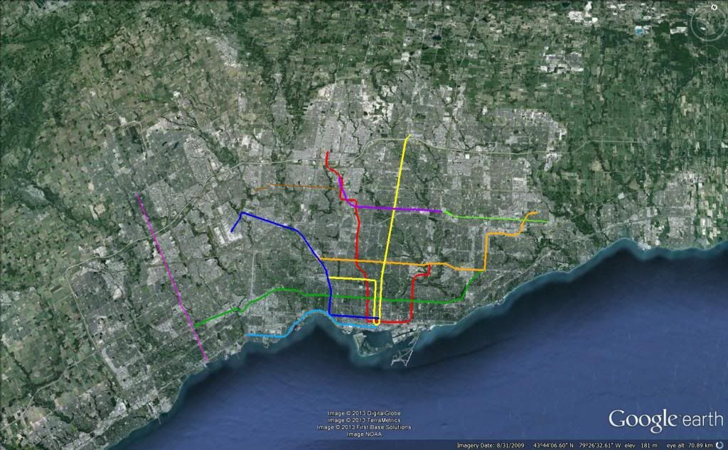
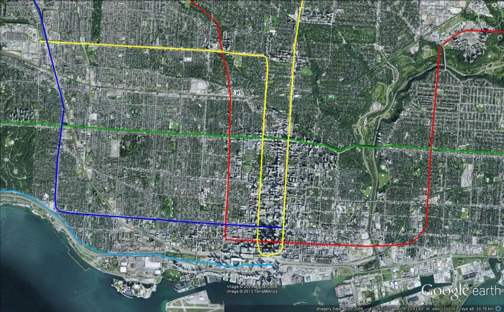
I think unless something revolutionary like this is done, Yonge-Bloor will continue to be the bottleneck regardless of the DRL. Whether this is the solution or not, I am not sure - but it is quite an interesting idea.

I think the general employment density in the core has shifted south and west since integrated operations, which would suggest relatively more relief potential for Yonge and Bloor. For Westbound Bloor passengers, an integrated BD-YUS downtown train would be time competitive with a transfer at Yonge-Bloor for anything south or west of King Station.

Dunno, not a typical way of thinking about Yonge-Bloor relief.

I'm not sure about how easy the wye would be to bring back. Based on what Steve Munro and this Briganti have written, the TTC bungled integrated operations by forcing trains to maintain sequence through the junction. Apparently once they changed that things went ok. With more modern signalling and better route management it shouldn't be very hard.

I doubt there is room along Bloor, but I think it would be nicer to send the line down Bay instead of Spadina. As long there is a transfer at Spadina, I think it would be ok to not have any station between Spadina and College/Wellesley.

Spadina uncouple at Bay.jpg
 

Attachments

  • Spadina uncouple at Bay.jpg
    Spadina uncouple at Bay.jpg
    93.7 KB · Views: 761
I dream of a subway on Spadina replacing the streetcar down to Lake Shore, and recovering the space from the ROW to widen the sidewalks and have substantial bike lanes, for a sort of grand, contemporary Champs-Elysee-style boulevard. The public realm and architectural standards would be the highest in the city.
 
I dream of a subway on Spadina replacing the streetcar down to Lake Shore, and recovering the space from the ROW to widen the sidewalks and have substantial bike lanes, for a sort of grand, contemporary Champs-Elysee-style boulevard. The public realm and architectural standards would be the highest in the city.

There's a subway line less than 400m away. Install signal priority on Spadina, scrap some of the stops and call it a day. We'll now have rapid transit on Spadina for not even a few million dollars.

If you're concerned about the "Champs-Elysee-style boulevard", tear down the Gardiner and replace it with that. It's a far better location as well and is actually realistic from an urban planning point of view.
 
Some of you may be aware of the web comic xkcd - it's a developer/tech geek comic that tends to do some wonderful works of design occasionally, and today's is one of those. Today's strip is "Subways of North America" with the system maps - including Toronto - all joined together in one design. It makes for a quite interesting way to compare relative subway systems complexity.

http://xkcd.com/1196/

As a bonus, the famed Springfield monorail system is also in there. :)
 
Last edited:
Some of you may be aware of the web comic xkcd - it's a developer/tech geek comic that tends to do some wonderful works of design occasionally, and today's is one of those. Today's strip is "Subways of North America" with the system maps - including Toronto - all joined together in one design. It makes for a quite interesting way to compare relative subway systems complexity.

http://xkcd.com/1196/

As a bonus, the famed Springfield monorail system is also in there. :)

It's entertaining, because for San Francisco, they didn't just include BART, but also the Muni LRT system, including all of the at-grade surface road routes.
 
Some of you may be aware of the web comic xkcd - it's a developer/tech geek comic that tends to do some wonderful works of design occasionally, and today's is one of those. Today's strip is "Subways of North America" with the system maps - including Toronto - all joined together in one design. It makes for a quite interesting way to compare relative subway systems complexity.

http://xkcd.com/1196/

As a bonus, the famed Springfield monorail system is also in there. :)

For the pedantic rail enthusiasts, the definition of a subway used here is, with some caveats, "a network containing high capacity grade-separated passenger rail transit lines which run frequently, serve an urban core, and are underground or elevated for at least part of their downtown route." For the rest of you, the definition is "an underground train in a city."

They know their audience well.
 
Some of you may be aware of the web comic xkcd - it's a developer/tech geek comic that tends to do some wonderful works of design occasionally, and today's is one of those. Today's strip is "Subways of North America" with the system maps - including Toronto - all joined together in one design. It makes for a quite interesting way to compare relative subway systems complexity.

http://xkcd.com/1196/

As a bonus, the famed Springfield monorail system is also in there. :)

I can't find the monorail :eek:
 
Even his definition is bent several times in this map:

L.A. Orange Line (which is BRT) made it in.
Boston Green Line (not grade separated) is in.

Meanwhile, Edmonton, which is decidedly grade separated in the core, is out.
 
Look for the red loop just down and to the left from Vancouver.
You see, Springfield is partially based on Portland, Oregon, where creator Matt Groening grew up.
Even his definition is bent several times in this map:

L.A. Orange Line (which is BRT) made it in.
Boston Green Line (not grade separated) is in.

Meanwhile, Edmonton, which is decidedly grade separated in the core, is out.
Same goes with the Buffalo Metrorail, which is grade-separated (and underground) outside of downtown; it is not on the map
 
Based on the discussion above, welcome to the land of interlining, hahaha. For all of the changes, there's actually relatively little new subway in this scheme. There's the DRL, the new subway under Spadina, and the Sheppard West connector.

The plans for both the Spadina and Yonge Subways involve short-turning at the current terminus points, with only every 2nd train continuing northward. This scheme kind of incorporates that already by splitting the routes around those points.

Interlining Scenario.jpg
 

Attachments

  • Interlining Scenario.jpg
    Interlining Scenario.jpg
    97.5 KB · Views: 648
Based on the discussion above, welcome to the land of interlining, hahaha. For all of the changes, there's actually relatively little new subway in this scheme. There's the DRL, the new subway under Spadina, and the Sheppard West connector.

The plans for both the Spadina and Yonge Subways involve short-turning at the current terminus points, with only every 2nd train continuing northward. This scheme kind of incorporates that already by splitting the routes around those points.

View attachment 12120

Can you add in the ARL with the added stations so we can see what it could look like.. I do like this plan.... The trains in Calgary were interlined and I thought it worked well.. I like how this looks.
 
my idea, involving only 1 small interlining, for sheppard to run up to York U. it would not have seperate tunnels as the image suggests, it's just difficult for me to put interlined images in my map, with the way I create it. I included the DRL from eglinton south, the University line being extended to saint clair, and run down that street, the Spadina line running down Spadina to connect to the DRL, an extension of the Bloor line to Hurontario using the rail corridor, the elevation of eglinton through Scarborough, The western DRL would be a converted Union Pearson express that now runs through the downtown on queen, an extension of the sheppard line to Downsview where it would interline to York U, helping connect to the Finch LRT for easier crosstown travel, and a Lake Shore line that runs to Long Branch.

subway_zps924cf6ad.jpg


downtown specific:


subway1_zps4560ef43.jpg
 

Back
Top