

M II A II R II K
Senior Member
There’s also the Lawrence jog, the St. Clair jog and the Landsdowne jog.
|
|
|
Why was Lawrence disconnected? Seems they could have kept that connection and just run the road under Bayview.
It used to run under Leslie - the are remnants of the old roadway underneath the Leslie bridge, including a small bridge over the river.
Rather, it was Leslie that was discontinuous with Lawrence being the through road there. That changed with the construction of the high-level bridge in the 1950s.
Dan
Toronto, Ont.
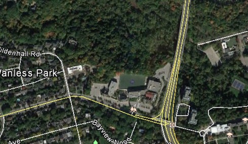
I'm not from Toronto... been here since 2006, and this a part of the city I have no idea about. However google earth identifies the bridge as bayview, and the top left white line as Lawrence.
I'm not from Toronto... been here since 2006, and this a part of the city I have no idea about. However google earth identifies the bridge as bayview, and the top left white line as Lawrence.
Torresdale in North York. Land is available and clearly it was planned to go through. Anybody know the history here?
There's the jog along Ellesmere at Victoria Park. Any idea why that happened? Ellesmere becomes Parkwoods Village Dr. than York Mills Rd.
Mississauga has two different concession measurements: one north of Eglinton and another south of Eglinton.Different concession measurements in different towns. If you follow all of the concessions north of Bloor/Danforth, they all jog to a degree when meeting Victoria Park.
In fact, in Scarborough Steeles isn't even the 7th concession road north of Danforth - Passmore is. They decided to make Steeles the boundary and a straight line right across what would become Toronto.
Dan
Toronto, Ont.
Kipling avenue ends at steeles and starts back up just south of hwy 7 (was known as 8th concession) i believe this was due to there being a garbage dump there many years ago.

