News   Jul 31, 2024
 29     0 
News   Jul 31, 2024
 305     0 
News   Jul 31, 2024
 279     1 

Discontinuous streets

I think it's just to protect the park. Pine Valley and Leslie are interrupted for the same reason.

No, Kipling was never really a through route north of Steeles. The road allowance was likely abandoned as a through route decades ago - Islington Avenue was nearby and Steeles wasn't continuous either until the 1970s. A tributary of the East Humber River runs through there.

And yes, there's an old dump north of the Steeles/Kipling intersection that was used in the 1960s. There's also the CN York Sub, built in the early 1960s (and of course, the 407).

Pine Valley is a concession line, similar to Islington to the south. But Islington leaves the grid to serve Woodbridge (it's a very old route) just south of Steeles and Pine Valley shifts east to meet Fermar because of the CP MacTier Sub.
 
not entirely related but does anyone know where the numbered east-west avenues in Markham get their names. they re clearly concessions separated by 2km but if theres 14th, 16th etc where is first (i tried counting down through toronto but theres not enough)
 
not entirely related but does anyone know where the numbered east-west avenues in Markham get their names. they re clearly concessions separated by 2km but if theres 14th, 16th etc where is first (i tried counting down through toronto but theres not enough)
There’s definitely enough: 19th, 18th-Elgin Mills, 17th-Major Mackenzie, 16th, 15th-Highway 7, 14th, 13th-Steeles, 12th-Finch, 11th-Sheppard, 10th-York Mills, 9th-Lawrence, 8th-Eglinton, 7th-St Clair, 6th-Bloor, 5th-College, 4th-Dundas, 3rd-Queen, 2nd-King, 1st-Front, 0th-Lakeshore, -1st-Queens Quay.
 
Last edited:
There’s definitely enough: 19th, 18th-Elgin Mills, 17th-Major Mackenzie, 16th, 15th-Highway 7, 14th, 13th-Steeles, 12th-Finch, 11th-Sheppard, 10th-York Mills, 9th-Lawrence, 8th-Eglinton, 7th-St Clair, 6th-Bloor, 5th-College, 4th-Dundas, 3rd-Queen, 2nd-King, 1st-Lakeshore, 0th-Queens Quay.

1st Concession was virtually always named Front St in any concession system. Much of the land south of Front St in Toronto today is reclaimed from the lake with infill.
 
There’s definitely enough: 19th, 18th-Elgin Mills, 17th-Major Mackenzie, 16th, 15th-Highway 7, 14th, 13th-Steeles, 12th-Finch, 11th-Sheppard, 10th-York Mills, 9th-Lawrence, 8th-Eglinton, 7th-St Clair, 6th-Bloor, 5th-College, 4th-Dundas, 3rd-Queen, 2nd-King, 1st-Front, 0th-Lakeshore, -1st-Queens Quay.

But that still doesn't really add up. If at 16th, it should be 32km south to the base line. But that would land it somewhere deep in the lake.
 
Pine Valley is a concession line, similar to Islington to the south. But Islington leaves the grid to serve Woodbridge (it's a very old route) just south of Steeles and Pine Valley shifts east to meet Fermar because of the CP MacTier Sub.

There's quite a few discontinuous streets through Woodbridge:
Kipling, twice. Pine Valley. Langstaff, many times.
 
1st Concession was virtually always named Front St in any concession system. Much of the land south of Front St in Toronto today is reclaimed from the lake with infill.

Actually, Lot Street was the Base Line, later renamed Queen Street. Bloor Street was the 1st Concession north of the base line.

From link.

Establishing the Baseline for York Township, 1791

This important survey by Augustus Jones established the eastern sideline (now Victoria Park Avenue) and the baseline (now Queen Street) for Dublin (York) Township. The township lines formed the basic framework for all later development and thus determined the eventual northwest-southeast orientation of Toronto. The survey recorded here began 90 miles east of Toronto at the Bay of Quinte and laid out the fronts of 11 townships between there and York. Wherever possible, the baselines of townships were laid out parallel to the lake shore.
 
But that still doesn't really add up. If at 16th, it should be 32km south to the base line. But that would land it somewhere deep in the lake.
Someone had noted on this thread before:
1st concession - Yonge, 2nd - Bayview, 3rd Leslie, 4th Woodbine, 5th Warden, 6th Kennedy, 7th McCowan, 8th Markham, 9th line, 10th Reesor, 11th concession, 14th Ave, 15th Hwy 7/Langstaff, 16th ave, ..
Assuming they skipped 12th and Steeles being 13th.
 
not entirely related but does anyone know where the numbered east-west avenues in Markham get their names. they re clearly concessions separated by 2km but if theres 14th, 16th etc where is first (i tried counting down through toronto but theres not enough)

Not a historian or a surveyor but any of the old survey maps I have seen of the area (McGill has a database), York County was surveyed with Yonge St. as the baseline and concessions running east and west (making 'concession roads' or 'lines' - the roads between each concession block - running north-south). What is now Steeles was the southern boundary. The land south of Steeles was another municipality/other municipalities and likely was already surveyed. With concession roads running north-south, 'sideroads' or 'sidelines' were run east-west every 5 lots to complete the grids. There is no real convention for numbering these sideroads, but it appears from the old maps that Markham Twp. used the number of the lot on the north side of the sideroads as the name.

A bit of an anomaly but it looks like in the first concession east of Yonge the lot numbers don't start at 1 like they do in the other concessions but seem to continue numbering from below what is now Steeles. This may have been because Yonge was surveyed as a military/development/settlement road and it was not uncommon to survey a single concession east and west of these early pioneer roads along their route since that would be the only land to be settled at that time.

https://digital.library.mcgill.ca/countyatlas/Images/Maps/TownshipMaps/yor-m-markham.jpg
 
14th Avenue and such are part of Markham surveying.

4th Concession (Eglinton Ave.) and such are part of York Township surveying.

They are not compatible.

Steeles Avenue is both 9th Concession (using York Township reckoning) and 13th Avenue (using Markham reckoning) simultaneously.
 
Someone had noted on this thread before:
1st concession - Yonge, 2nd - Bayview, 3rd Leslie, 4th Woodbine, 5th Warden, 6th Kennedy, 7th McCowan, 8th Markham, 9th line, 10th Reesor, 11th concession, 14th Ave, 15th Hwy 7/Langstaff, 16th ave, ..
Assuming they skipped 12th and Steeles being 13th.
12th is the York-Durham Townline.
 
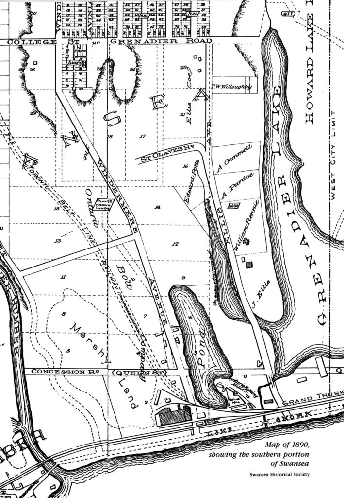
maps-swansea-1890-709x1024.jpg


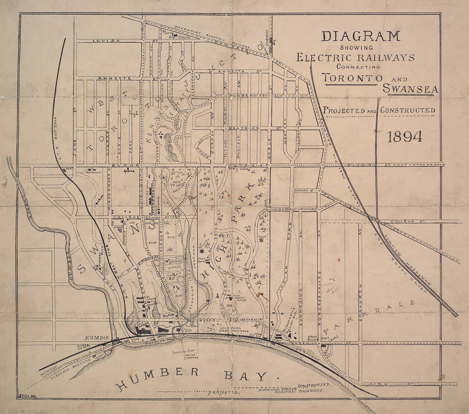
In 1894, College Street was envisioned to continue on into Swansea (today's Morningside Avenue), from link.

Swansea-map-from-Toronto-Library.jpg
 
  • Like
Reactions: vic
I wonder why the southernmost part of Jane St. was interlined with The Kingsway and later separated into South Kingsway only to be separated again to make a link of an extended Bloor St?

It looks like the powers that be felt they made a mistake with the street grid the first and decided to change it. You'd think they would have thought that a linked Bloor (and an intact Jane) was more important from the beginning.
 

Back
Top