


JMSRead
Active Member
Cool! I wonder if Smarttrack/Go RER would be included on that map.
|
|
|
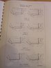
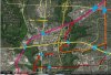
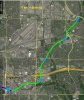
Second Segment: (South-East) North York
Targets: 1) ECLRT Interchange. 2) Other Stops
This is about 6 km, with several possible routes, with about 2 stations.
With ECLRT not being grade-separated, it makes it difficult to find a strong preference on where to cross Eglinton. Vic Park makes some sense as the busiest location, but it means another crossing of the hydro corridor. Near Leslie, alongside the CPR is easiest bus misses serving Flemindon. At Wynford, through the Don Valley is another option.
Depending on exact routing of DRL, could have an interchange at Don Mills/CPR, or at Science Centre, or leave the interchange for the Thorncliffe area.
View attachment 80217
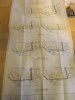
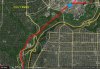
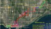
Third Segment: Thorncliffe and Don Valley
Targets: 1) Thorncliffe
This is about 4 km, with only 1 station.
The only stop here is at East York Centre Mall. Depending on DRL alignment, an interchange could be made with the DRL could be made, although near Science Centre is another possibility. The other goal here is to find a route that is fast, inexpensive, and disturbed the fewest number of NIMBY's.
View attachment 80218
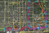
I am not very good with names, and stole (borrowed) this concept from someone here (and likely you). I know I have seen it just a week or so ago. I wanted a transit line with fairly high capacity and was a bit worried that making this a branch of the DRL would restrict that capacity of this branch and the branch up Don Mills to Finch to about 15k. I see this branch being a bit more heavily used than 15k (maybe 25k). I also see the Don Mills branch needing even higher capacity (likely 30k+), since it is expected to greatly relieve Yonge when it is extended to Finch (or even highway 7).I like the CPR alignment through Leslie the best. It is perfectly placed for massive redevelopment of the whole Don Mills north of Eglinton (Celestica grounds and surrounding area) site. If Toronto is truly going to have explosive population growth by 2040, this is an area where I think we must convert a lot of brownfield sites and employment lands into denser residential lands. The station location is also neatly in between Lawrence and Eglinton on Don Mills, so interchange with the Relief Line is warranted too.
I wouldn't worry about serving Flemingdon Park with this line. The Relief Line would take care of that no problem.
As for alignment south of Thorncliffe Park, depending on the type of vehicle intended for this line, I would simply have it take the DRL tunnel and branch it off to Union after crossing the Don River.
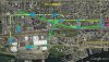
AWESOME map! Well done!
Only a few things I would change / add… for the relief line, wouldn’t the Pape station be renamed Danforth-Pape? It is on the Danforth. I suspect Queen-Pape will be named Queen East. I’d love to see the Eglinton Crosstown East line added.