News   Nov 22, 2024
 587     1 
News   Nov 22, 2024
 1K     5 
News   Nov 22, 2024
 2.8K     8 

Transit Fantasy Maps

Once again, your quality maps are only outdone by your innovative thinking.

I have yet to hear of a great plan for what to do with the Western leg, especially since it almost would follow the UP route. This solves that problem.

I also like interlining as a means of relieving Y-B. I think its much better for half the passengers to wait another 2 minutes (at some sparsely used station) for the proper train to arrive, than to have everyone transferring at the one interchange station.
 
Now the downside - political reality.

One problem with the proposal - people are entitled. Those on Spadina north like being able to go directly to Union or King - and they're used to it. The DRL goes close to those locations, but its not the same. We also live in a world where the squeeky wheel get the grease. This helps the commute for those coming from the north, east, and west, but that would likely be overshadowed by the few complaints from the Spadina line neighborhoods that suffer a minor change in travel.

Even people who only have a vague promise of transit (i.e. Vaughan 8 years ago, Scarborough, Sheppard), they have already come to expect that what they will get is tunneled subway. That is the reason I thought a brand new "Scarborough Line" would be a good replacement for the "Scarborough Subway" (B-D extension). Adding transit to a new area, they have not yet formed their entitlement for a tunneled subway. You can make the arguement that it is elevated or nothing. You also have to have an alternate route so that if this group doesn't want the line (i.e. Ellesmere), then the other area (i.e. Lawrence or Gatineau) will get it. The option isn't elevated or tunneled, because then locals will always demand tunneled. The option is elevated or nothing.
 
Once again, your quality maps are only outdone by your innovative thinking.

Gracias!

I have yet to hear of a great plan for what to do with the Western leg, especially since it almost would follow the UP route. This solves that problem.

Yup, most western leg proposals either use Queen or King, and either curve up or curve down. Curving up pretty much anywhere except for Dufferin involves a duplication of existing GO infrastructure. This just basically says "forget it, we'll tailor another piece of infrastructure to do a better job". The advantage of using streetcars (which in this scenario would be functionally identical to LRT), is that the routes can continue far beyond where the tunnel infrastructure ends, creating connections (to Dundas West for example) that would cost billions if subway technology was used.

I also like interlining as a means of relieving Y-B. I think its much better for half the passengers to wait another 2 minutes (at some sparsely used station) for the proper train to arrive, than to have everyone transferring at the one interchange station.

Exactly. People would rather wait an extra couple of minutes for a one-seat ride, especially if it means those getting on at Kipling or Kennedy has a seat for their entire trip downtown. The frequencies during peak can be tailored to demand (ex: 2 trains downtown, 1 train thru).

This completely negates the need to spend $1 billion+ expanding Bloor-Yonge, money which can be spent on system expansion instead.

Now the downside - political reality.

One problem with the proposal - people are entitled. Those on Spadina north like being able to go directly to Union or King - and they're used to it. The DRL goes close to those locations, but its not the same. We also live in a world where the squeeky wheel get the grease. This helps the commute for those coming from the north, east, and west, but that would likely be overshadowed by the few complaints from the Spadina line neighborhoods that suffer a minor change in travel.

Acknowledged. The pitch I would use with them is that they'll no longer be crush loaded at St. George during peak, and the transfer volume at Spadina will be minimal (not very many people will be going from Dupont to Queen & Spadina). If they do need to reach Union, by the time the Yonge-University trains reach Osgoode, many people will have gotten off, so they won't be getting onto a packed train.

Even people who only have a vague promise of transit (i.e. Vaughan 8 years ago, Scarborough, Sheppard), they have already come to expect that what they will get is tunneled subway. That is the reason I thought a brand new "Scarborough Line" would be a good replacement for the "Scarborough Subway" (B-D extension). Adding transit to a new area, they have not yet formed their entitlement for a tunneled subway. You can make the arguement that it is elevated or nothing. You also have to have an alternate route so that if this group doesn't want the line (i.e. Ellesmere), then the other area (i.e. Lawrence or Gatineau) will get it. The option isn't elevated or tunneled, because then locals will always demand tunneled. The option is elevated or nothing.

That's a good point. To a large extent, this alignment doesn't negate that. I've shown the Spadina-Pape line terminating at Pape, but it could just as easily be extended north of the Danforth on any number of alignments. I just figured that was a whole other scope that wasn't related to the downtown solutions that I was proposing here.

It would be better if the Yonge-University line terminated at Spadina Station during off-peak.

I had thought about that, but the issue is that if it were to terminate at Spadina, it would be parking trains on live tracks (using either the Bloor or Spadina platforms). With St. George, you'd have the upper level reserved exclusively for parking and turning, whereas the lower level would be the live Bloor-Danforth tracks. In short, by short-turning there you don't impact Bloor-Danforth or Spadina-Pape operations at all. It's unfortunate, but rectifying that situation would mean a pretty expensive alteration.

Another option would be adding a 3rd track to Spadina (Bloor) either on the north or south side, and creating a 3 track, 2 platform station, where the middle track would be the turning track, and the 2 outer tracks would be the Bloor-Danforth thru tracks. But again, that's a pretty expensive solution. You may be able to couple that project in with the demolition of the redundant streetcar loop though.
 
Last edited:
^ very nice map!

Here's something I've been toying with:

Link: https://dl.dropboxusercontent.com/u/43869799/DRTES_v3 (Diagrammatic).jpg

There are two main infrastructure components:
1) An extension of the Relief Line up Spadina to connect to the existing Spadina Subway.
2) A streetcar subway under King/Wellington/Church.

Benefits to the Lower Spadina Subway:
  • Allows for the Yonge-University line to use the original wye, drastically reducing pressure on Bloor-Yonge. The Yonge-University line would extend in both directions on Bloor-Danforth during peak, but terminate at St. George outside of peak. With ATC being installed on both lines, the 1960s interlining issues shouldn't be a problem.
  • Allows for both Yonge-University and Spadina-Pape lines to use Wilson as their main yard, negating the need for a separate DRL yard.
  • Adds operational redundancy to the downtown subway system (two separate lines heading northbound out of downtown).
Benefits to the King/Wellington Streetcar Subway:
  • A Waterfront/CBD loop connects the two, bypassing Union and reducing pressure on the streetcar loop (and potentially negating the need for its expansion).
  • Can be built as a tunnel, but if an extension of Church St is built, can also be built at-grade as an interim solution (using King instead of Wellington).
The reality is that the alignments and technology required to provide the 'relief' aspect of the DRL east of downtown are different from the transit improvements required west of downtown. Trying to shoehorn both of these goals into one single alignment using one technology is sub-optimal. By splitting the two up, this version of the DRL provides far more relief since it allows for the reactivation of the wye, while the streetcar subway provides the transit improvements the areas immediately west of downtown need.

Thoughts?

Well done. Is this a downtown inset for a larger map, or a screenshot of just the southern portion? Reason I ask is that I've been trying to make a fantasy map, but couldn't fit everything in without having to create an inset. And the addition of the inset proved too big a task that I gave up.

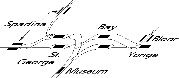
Although I'd prefer the Queen line go further west, I think a N/S route along Spadina is an interesting proposition - particularly if we're to bring back interlining and keep all lines CBD-bound. One thing I'm wondering though is the infrastructure complexity. Would there need to a be a new flyover/flyunder to align the U/S leg along Spadina, and how much is the current streetcar tunnel/loop in the way for that? This is a TTC schematic of track structures (not to scale) if you or anyone else is interested. When knowing how the tracks connect with each other it definitely makes it easier to understand the possibility and potential merits of an interlined system.

tlmapc.jpg
 

Attachments

  • tlmapc.jpg
    tlmapc.jpg
    49.8 KB · Views: 1,159
Hi everybody, I'll like to submit my proposal for all those wonderful fantastical transit maps out there.

I'd add a North-South Etobicoke LRT. It would start at Humber College, go south to Pearson (Highway 27, Dixon), then around the airport to Renforth Gateway (interline with ECLRT west), then all the way to Long Branch (Renforth, Rathburn, East Mall, Sherway, Browns Line, Lakeshore).
 
Last edited:
This is a TTC schematic of track structures (not to scale) if you or anyone else is interested.
View attachment 81536

Here is another sketch that help clarify what is going on at Spadina, Lower Bay, etc. I am unsure of the exact station elevations, but the suppose the plan for gweed123 would be for the Spadina leg to utilize the SpadinaNorth platforms. Could the new Spadina subway be kept a bit west of the LRT loop (to allow that to be retained) and still curve to connect with SpadinaNorth

subway-5104-04.gif
 
The way I see it is that the Spadina leg would cross the Bloor-Danforth tracks immediately east of Spadina station, where the track level is still relatively deep. This would need to be a pretty shallow tunnel, but it could probably be done.

The Streetcar loop in this instance would be redundant, since the line would be discontinued with the opening of the subway.

Both Spadina platforms would remain in service, with the existing connection between them being maintained (and maybe with the moving walkway re-introduced). Depending on where Harbord Station is placed, a new walking connection could be implemented there too.

And this is a downtown-specific map that I created. It could be part of a larger system map if I chose to expand it, but I don't know if I'll do that.
 
So Line 1 and 2 would work as follows:
-during peak -> every other train on Line 2 runs the existing routing (assumes that through routing spacing is twice that of Line 1, which is probably even shorter than it actually is).
-> every other train diverts to upper St. George platform east of Spadina and then goes around the loop - I guess we'll have to start using platform numbers in TTC stations
-> every other train diverts to lower Bay platform west of Yonge then goes around the loop.
-off-peak
-> lower Bay is not serviced
-> upper St. George is a terminal, with trains using the crossover before the station to switch directions before pulling into the station

I like it. And unless you want some redundancy south of College for Bathurst blockages, you would return Spadina to a park-filled boulevard north of Queen.
 
Last edited:
I like the idea of a westerly DRL route closer to the core. Have you considered what would happen to the Spadina streetcar route though? Would it make any sense to do away with the interlining scheme and run the western DRL leg up Bathurst to St. Clair West and use that station as a major terminal for Yonge-University trains?
 
So Line 1 and 2 would work as follows:
-during peak -> every other train on Line 2 runs the existing routing (assumes that through routing spacing is twice that of Line 1, which is probably even shorter than it actually is).
-> every other train diverts to upper St. George platform east of Spadina and then goes around the loop - I guess we'll have to start using platform numbers in TTC stations
-> every other train diverts to lower Bay platform west of Yonge then goes around the loop.
-off-peak
-> lower Bay is not serviced
-> upper St. George is a terminal, with trains using the crossover before the station to switch directions before pulling into the station

I like it. And unless you want some redundancy south of College for Bathurst blockages, you would return Spadina to a park-filled boulevard north of Queen.

Yup, that's pretty much it! The ratio of Loop trains to Thru trains during peak can be adjusted based on demand though. 1 for 1 is just a good starting point.

I like the idea of a westerly DRL route closer to the core. Have you considered what would happen to the Spadina streetcar route though? Would it make any sense to do away with the interlining scheme and run the western DRL leg up Bathurst to St. Clair West and use that station as a major terminal for Yonge-University trains?

My thought was that, as jcam mentioned, Spadina north of Queen would be turned into a boulevard, with the median space being taken up by a combination of a landscaped median, wider sidewalks, and bike lanes. South of Queen, the ROW would be maintained, and is obviously used for the Central Loop south of King.

I also considered Bathurst, but the issue with that is it renders two existing subway stations useless (Dupont and Spadina). It would also require an extra 2km of tunnelling to make that happen. The cost isn't worth the marginal added benefit IMO. The goal of this plan was to have Spadina connect with the DRL with the least amount of new trackage as possible.
 
Since it's almost a year before the extension opens, I'm surprised the TTC hasn't released a map of re-organized bus routes. I threw together a map on Google to predict how the buses will interchange with the new stations.

Please forgive the confusion - I put this together in a hurry - but I'll do my best to explain the routes. This is a rough first draft so suggestions for improvement are welcome.

Sheppard West (currently Downsview):
Screenshot 2016-10-17 20.12.52.png

Unaffected routes
84 Sheppard West
101 Downsview Park
104 Faywood

Rerouted/Moved/Modified/etc. routes
105 Dufferin North:
  • 105C retained
  • 105A & 105B discontinued, to be replaced with YRT service
106 York University:
  • Rerouted to Finch West Station (see below)
108 Downsview:
  • Rerouted to Pioneer Village station (see below)
117 Alness:
  • Moved to Finch West station (see below)

Discontinued/Replaced routes
107 Keele North:
  • Service north of Steeles replaced with YRT service
  • 107C, D replaced with branch of 41 route (see below)
  • I still can't figure out a way to replace 107B, so I'll leave it blank for now
196 York University Rocket:
  • This route would be redundant due to the subway extension
Downsview Park:
Screenshot 2016-10-17 23.50.42.png


Since there is no direct bus connection to this station (IIRC, the loop is a PPUDO), this station would be served by routes 84, 101, 106 and 108 at the bus stop at Sheppard and Bakersfield Street (not shown: The new street and loop being built for the station).


Finch West:
Screenshot 2016-10-18 00.19.22.png


Unaffected route:
36 Finch West

Rerouted/Moved/Modified/etc. routes
41 Keele:
  • 41E would only run between Keele and Finch West stations
  • A new branch would take a detour via Lepage Ct, Ceramic Rd and St. Regis Cr to replace 107C, D service in the industrial area.
  • Instead of entering the York campus, 41A would simply run from Keele station to Steeles & Petrolia:
    Screenshot 2016-10-18 00.01.30.png
106 York University:
  • This was tricky, since I would want to continue service through the Village and along Sentinel.
  • The bus would follow its current route from Sheppard West; but it would turn right at Sentinel and the Pond Rd and go all the way to Keele, then travel down to Finch West.
117 Alness:
  • This route would run along the York University busway to Alness St, at which point it would continue on its current routing
199 Finch Rocket:
  • This route would also run along the busway as it currently does, but would end at Finch West.
York University:
Screenshot 2016-10-18 00.43.41.png


If York gets their way, there won't be any TTC buses running on campus.

Pioneer Village:
Screenshot 2016-10-18 00.29.27.png


Unaffected routes:
60 Steeles West
84 Sheppard West
  • I was considering rerouting the 84D to Pioneer Village since it terminates pretty close to the station, but I'll leave it for now

Rerouted/Moved/Modified/etc. routes
35 Jane:
  • 35A, B rerouted to Pioneer Village station
  • 35C discontinued (would be redundant IMO)
  • 35D discontinued, to be replaced with YRT service
108 Downsview:
  • This route would run from Pioneer Village station to Jane and Steeles, then south on Jane to Driftwood, then along Driftwood, basically following the current 108A (or 108B) route to Sheppard West station
195 Jane Rocket:
  • Rerouted to Pioneer Village station
 

Attachments

  • Screenshot 2016-10-17 20.12.52.png
    Screenshot 2016-10-17 20.12.52.png
    115.2 KB · Views: 1,289
  • Screenshot 2016-10-17 23.50.42.png
    Screenshot 2016-10-17 23.50.42.png
    41.6 KB · Views: 1,250
  • Screenshot 2016-10-18 00.01.30.png
    Screenshot 2016-10-18 00.01.30.png
    86.9 KB · Views: 1,237
  • Screenshot 2016-10-18 00.19.22.png
    Screenshot 2016-10-18 00.19.22.png
    100.8 KB · Views: 1,297
  • Screenshot 2016-10-18 00.29.27.png
    Screenshot 2016-10-18 00.29.27.png
    199 KB · Views: 1,289
  • Screenshot 2016-10-18 00.43.41.png
    Screenshot 2016-10-18 00.43.41.png
    84.4 KB · Views: 1,263
Since it's almost a year before the extension opens, I'm surprised the TTC hasn't released a map of re-organized bus routes. I threw together a map on Google to predict how the buses will interchange with the new stations.

117 Alness:
  • Moved to Finch West station (see below)

Discontinued/Replaced routes
107 Keele North:
  • Service north of Steeles replaced with YRT service
  • 107C, D replaced with branch of 41 route (see below)
  • I still can't figure out a way to replace 107B, so I'll leave it blank for now
106 York University:
  • This was tricky, since I would want to continue service through the Village and along Sentinel.
  • The bus would follow its current route from Sheppard West; but it would turn right at Sentinel and the Pond Rd and go all the way to Keele, then travel down to Finch West.
117 Alness:
  • This route would run along the York University busway to Alness St, at which point it would continue on its current routing
108 Downsview:
  • This route would run from Pioneer Village station to Jane and Steeles, then south on Jane to Driftwood, then along Driftwood, basically following the current 108A (or 108B) route to Sheppard West station
If I may offer some suggestions.

107B and 117 should be combined and routed out Sheppard West (Downsview) Stn for a continuous route from Sheppard to Steeles.

106 York University should continue serving Ian McDonald Blvd and the Aviva Centre and end at Steeles West (Pioneer Village) Stn. Looping back to Finch/Keele is pointless.

108 Downsview could terminate at the new Downsview Park Stn (on-street transfer). On the other end after Driftwood and Jane, run north on Jane, east on Shoreham then north on Murray Ross Pkwy to Steeles West (Pioneer Village) Stn.
 
I could still see Routes 41, 106, and 60C serving the campus, on the ring road and at least the 60C continuing to Steeles West Station. YRT, of course, plans to operate a few routes on the ring road as well. Gone, however, will be the bus loop in front of Vari Hall, and the 195/196 buses.
 
Downsview Park: Since there is no direct bus connection to this station (IIRC, the loop is a PPUDO), this station would be served by routes 84, 101, 106 and 108 at the bus stop at Sheppard and Bakersfield Street (not shown: The new street and loop being built for the station).

Is this confirmed that buses won't be driving into the station? Incredibly ridiculous if passengers are forced to walk out onto the street to catch any connecting buses.
 

Back
Top