News   Apr 19, 2024
 280     1 
News   Apr 19, 2024
 611     0 
News   Apr 18, 2024
 1.3K     2 

Waterfront Transit Reset Phase 1 Study

How should Toronto connect the East and West arms of the planned waterfront transit with downtown?

  • Expand the existing Union loop

    Votes: 200 73.3%
  • Build a Western terminus

    Votes: 10 3.7%
  • Route service along Queen's Quay with pedestrian/cycle/bus connection to Union

    Votes: 28 10.3%
  • Connect using existing Queen's Quay/Union Loop and via King Street

    Votes: 19 7.0%
  • Other

    Votes: 16 5.9%

  • Total voters
    273
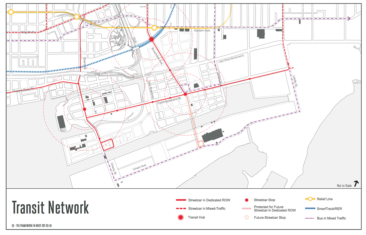
IIRC the design and planning for the connection between Exhibition Loop and Dufferin Gate Loop seems to be even farther along than the planning for the Union and Queen's Quay expansion and the extension along Queen's Quay East. Granted, the Exhibition Place extension is a far simpler and less expensive project, but I think it's pretty likely that we see the connection to Dufferin open well before the Union & Queen's Quay expansion and the QQE extension.

This file was probably posted in this thread a long time ago, but this shows the striking level of design already on the Exhibition Place extension. I haven't seen anything near this level of detail for the Union/QQ expansion or the QQE extension, but please feel free to correct me if I'm wrong and if there is more detailed design done on either of the two extensions.
Fare gates at Dufferin Gate Loop?
EAF927B2-9E2C-4779-997B-188180BB71B2.jpeg
 
There is documentation, dated February, 2018, for the Exhibition GO Station. Probably also having to be done all over again because of the Ontario Line.

From link.

site-plan-large.jpg

It shows the westbound streetcars could shift south to westbound tracks heading to the Dufferin Loop. Also possible reverse loop for eastbound streetcars needing to go back.
This show the reversing loop that I have asked about. If you compare this one to the current one, the angle track is a lot closer to the west end of the loop in the current plan than this one. This plan has the existing tracks remaining as is, but the current plan has the tracks moving south, or the extension moving north.

The other thing I noticed and miss, the buses will enter the Dufferin loop off Dufferin, opposite the way it happen today and will cause a backup on Dufferin for southbound buses, as well trying to exit against the inbound streetcars.
 
I think just a streetcar from the cherry loop to Union station would suffice.
Polish_20200613_055418166.jpg
 
Last edited:
I think just a streetcar from the cherry loop to Union station would suffice.View attachment 251275
Not according to TTC. They see a number of options:
Broadview to Union; an east-west line bypassing Union; Portland to Union; plus another 7. Then you got the west side and that is another 5 options.

TTC still has the Bremner line on their map, even though it been removed by the city. The portal was to be on the east side of York and will now have to be on the west side with a number of issues doing so. TTC still wants a Bathurst line running to Union by Bremner and that show up 15 years ago.

What was vision 15 year for ridership numbers is at least triple plus based on the current plans and there still a lot of unknown sites for density developments.
 
@Drum 118 is correct that there are several possibilities for routing streetcars along Queens Quay. They were discussed during the long-ago public meetings for the Transit EA. At that time, the TTC seemed to favour most (or all) streetcars going east to west (and vice versa) via Union and very few (or none) just running straight through the T junction at Bay Street. As the East Bayfront (east of Bay Street) will have many residents (and some offices) when the line opens I assume they will re-evaluate. The bottom line is that the Union loop and tunnel must be upgraded before anything can change and it must be possible to operate a 'straight-through" route - even if most may go via or end at Union loop. At one point the TTC said that a straight-through route (a T junction) was impossible due to things under the street but I think it is now part of what is planned.
 
I think just a streetcar from the cherry loop to Union station would suffice.
Not according to TTC. They see a number of options:
Broadview to Union; an east-west line bypassing Union; Portland to Union; plus another 7. Then you got the west side and that is another 5 options.

TTC still has the Bremner line on their map, even though it been removed by the city. The portal was to be on the east side of York and will now have to be on the west side with a number of issues doing so. TTC still wants a Bathurst line running to Union by Bremner and that show up 15 years ago.

What was vision 15 year for ridership numbers is at least triple plus based on the current plans and there still a lot of unknown sites for density developments.

Broadview to Union seems ideal.

Would the plan be to go on the old Eastern Avenue bridge and then onto Bayview in the Donlands? Seems most logical.
 
I think just a streetcar from the cherry loop to Union station would suffice.

Would the plan be to go on the old Eastern Avenue bridge and then onto Bayview in the Donlands? Seems most logical.

No.

Broadview is to be extended south into the Portlands.

Any LRT will be an extension of tracks down Broadview.
 
I think just a streetcar from the cherry loop to Union station would suffice.


Broadview to Union seems ideal.

Would the plan be to go on the old Eastern Avenue bridge and then onto Bayview in the Donlands? Seems most logical.

From link. Dated May 5, 2017, back when they were looking at a "Relief Line" instead of the "Ontario Line".

26578-93189.png
 
The "West Don Lands Loop" will either be a rebuild of the existing "Distillery Loop" or a new loop or new tracks added to the "Distillery Loop".
View attachment 251330
From link.
Been so long since we design it, got to do some thinking and maybe off some what.

The first issue is, will the underpass be rebuilt to allow everything to continue south like it is on the north side with wider sidewalks, bike lanes and more clearance by lowering the road??

Will there be holes punch in the embankment on either side of the current underpass to allow for a new underpass for the streetcars, pedestrians and cycles???

Will the existing road be lower to allow for the streetcars to use the current underpass and holes punch on either side for pedestrians and cycles??? Streetcars will use the northbound lanes and traffic using the southbound lanes in both directions.

These were the 3 options we looked at during the EA and design stage, with a new underpass been the prefer one at a cost of $50 million today. This option will have the biggest impact on rail service since you will have haft the tracks out of service while building the new underpass.

All 3 options would see a northbound track crossing the loop track and connecting to the current line that would see a switch added to it for the loop. A switch would be added to the southbound track for the loop.

Since the Cherry St Line is not going into the Portland until about 2030-40, there seem to be no rush to decide what should take place and how it will be funded. Also, no plans have surface for the new extension of the Queens Quay from Parliament St to the new Cherry St as well development for the land there at this time. There is a vision what QQ may look like, but only a vision..
 
If the current tracks are already off street to the east of Cherry Street, think they'll just drill/dig/construction a streetcar only underpass under the railway. All there is only a parking lots and empty weed fields.

1592102150834.png

From link. They above image is the current Cherry Street underpass looking north from Lake Shore Blvd. East.
 
If the current tracks are already off street to the east of Cherry Street, think they'll just drill/dig/construction a streetcar only underpass under the railway. All there is only a parking lots and empty weed fields.
I have seen a 'plan' for a streetcar tunnel to be punched through the rail berm to east of the current bridge. I think this was part of the Metrolinx documents about adding tracks to the rail line and the widening of all the bridges between Yonge and Parliament. The current 'signal box' on north side of the berm and east of the bridge will (soon) be obsolete and it will be moved a bit further east. When it is not there the new streetcar tunnel COULD go through - but I doubt it will happen for many years.
 

Back
Top