News   Apr 24, 2024
 905     1 
News   Apr 24, 2024
 1.3K     1 
News   Apr 24, 2024
 607     0 

TTC: St. Clair Streetcar Right Of Way

St. Clair Avenue West Area Transportation Master Plan

Notice of Completion

From link.

Issue Date: July 4, 2019
The City of Toronto has completed a Transportation Master Plan (TMP) to examine solutions to relieve traffic congestion, improve connections for pedestrians and cyclists, and increase access to public transit (including the future St.Clair-Old Weston SmartTrack Station), in the area of St. Clair Avenue West, between Keele Street and Old Weston Road. The TMP study followed the Municipal Class Environmental Assessment (EA) Study (Schedule C). The Ministry of Infrastructure (MOI) Public Work Class EA process was also followed in support of the purchase of MOI owned land required for the recommended improvements. The recommendations as documented in the TMP are to:​
  1. Widen St. Clair Avenue West
  2. Extend Gunns Road to Union Street
  3. Extend Keele Street to meet the Gunns Road Extension
  4. Extend Davenport Road to Union Street
Please contact Robyn.Shyllit@Toronto.ca if you would like to view the report appendices listed below:
  • A Natural Environment Memo
  • B Arborist Report
  • C-1 Phase One Environmental Site Assessment (Study Area)
  • C-2 Phase One Environmental Site Assessment (153 Weston Road)
  • D Soil and Groundwater Management Plan
  • E-1 Noise Memo
  • E-2 Toronto Municipal Code, Chapter 591, Noise
  • E-3 Toronto Municipal Code, Chapter 363, Vibrations from Construction Activity
  • F-1 Stage 1 Archaeological Assessment Report
  • F-2 Stage 1 -2 Archaeological Assessment Report
  • F-3 Stage 1-2 Archaeological Assessment Report, Record of Indigenous Engagement
  • G Cultural Heritage Existing Conditions and Impact Assessment Report
  • H Utility Report
  • I-1 Traffic Operational Analysis Report
  • I-2 Transportation Analysis Summary
  • J Long-Term Alternatives Evaluation Matrix
  • K-1 Evaluation of Potential TTC Streetcar Stop Below St. Clair Rail Bridge
  • K-2 Gunns Road Extension Alternatives Evaluation Memo
  • K-3 Keele Street Extension Re-Alignment Option Evaluation
  • K-4 Davenport Road Alignment Evaluation
  • L-1 Detail Design: St. Clair Avenue West
  • L-2 Detail Design: Gunns Road Extension
  • L-3 Detail Design: Keele Street Extension to Gunns Road
  • L-4 Detail Design: Davenport Road – Union Street Extension
  • M-1 Record of Consultation
  • M-2 St. Clair West Conceptual Constructability Review Workshop Memo
  • N Environmental Impact Statement for The Proposed Keele Street Extension
 
Knowing this city, they'll pussyfoot around this and say it's "too expensive" and it will go the way the ~$300 million Front Street Extension proposal went.
 
Knowing this city, they'll pussyfoot around this and say it's "too expensive" and it will go the way the ~$300 million Front Street Extension proposal went.
John Tory's ST station needs this improvement, so many it will happen if he's still around.
 
St. Clair Avenue West Area Transportation Master Plan

Notice of Completion

From link.

Issue Date: July 4, 2019
The City of Toronto has completed a Transportation Master Plan (TMP) to examine solutions to relieve traffic congestion, improve connections for pedestrians and cyclists, and increase access to public transit (including the future St.Clair-Old Weston SmartTrack Station), in the area of St. Clair Avenue West, between Keele Street and Old Weston Road. The TMP study followed the Municipal Class Environmental Assessment (EA) Study (Schedule C). The Ministry of Infrastructure (MOI) Public Work Class EA process was also followed in support of the purchase of MOI owned land required for the recommended improvements. The recommendations as documented in the TMP are to:​

  1. Widen St. Clair Avenue West
  2. Extend Gunns Road to Union Street
  3. Extend Keele Street to meet the Gunns Road Extension
  4. Extend Davenport Road to Union Street

Please contact Robyn.Shyllit@Toronto.ca if you would like to view the report appendices listed below:
  • A Natural Environment Memo
  • B Arborist Report
  • C-1 Phase One Environmental Site Assessment (Study Area)
  • C-2 Phase One Environmental Site Assessment (153 Weston Road)
  • D Soil and Groundwater Management Plan
  • E-1 Noise Memo
  • E-2 Toronto Municipal Code, Chapter 591, Noise
  • E-3 Toronto Municipal Code, Chapter 363, Vibrations from Construction Activity
  • F-1 Stage 1 Archaeological Assessment Report
  • F-2 Stage 1 -2 Archaeological Assessment Report
  • F-3 Stage 1-2 Archaeological Assessment Report, Record of Indigenous Engagement
  • G Cultural Heritage Existing Conditions and Impact Assessment Report
  • H Utility Report
  • I-1 Traffic Operational Analysis Report
  • I-2 Transportation Analysis Summary
  • J Long-Term Alternatives Evaluation Matrix
  • K-1 Evaluation of Potential TTC Streetcar Stop Below St. Clair Rail Bridge
  • K-2 Gunns Road Extension Alternatives Evaluation Memo
  • K-3 Keele Street Extension Re-Alignment Option Evaluation
  • K-4 Davenport Road Alignment Evaluation
  • L-1 Detail Design: St. Clair Avenue West
  • L-2 Detail Design: Gunns Road Extension
  • L-3 Detail Design: Keele Street Extension to Gunns Road
  • L-4 Detail Design: Davenport Road – Union Street Extension
  • M-1 Record of Consultation
  • M-2 St. Clair West Conceptual Constructability Review Workshop Memo
  • N Environmental Impact Statement for The Proposed Keele Street Extension
It involves building and widening roads. Should be a cinch from the province.
 
St. Clair Avenue from Yonge westwards with the streetcar down the middle is lovely and the one of the best streets in Toronto if not the best. Looks grand especially from Yonge to Bathurst. Wish need more of it in Toronto. I welcome these improvements in making it better.
If the City gets off its ass and start the 2010 EA for widening St Clair W to Dundas St as well building the rest of the ROW on it, it would even be better.

Just think what Toronto would like if it had another 150 km of streetcar lines that I proposed back around 2005-07. This was before Transit City surface.
 
St. Clair Avenue from Yonge westwards with the streetcar down the middle is lovely and the one of the best streets in Toronto if not the best. Looks grand especially from Yonge to Bathurst. Wish need more of it in Toronto. I welcome these improvements in making it better.

If they had just "improved" the right-of-way with grass (artificial or otherwise) and WITHOUT the left turn lanes, St. Clair would look much better. However, they had to appease the automobile gods by putting in left turn lanes and giving the single-occupant in them priority over the streetcars.

f1568_it0248.jpg

From link.
 
If they had just "improved" the right-of-way with grass (artificial or otherwise) and WITHOUT the left turn lanes, St. Clair would look much better. However, they had to appease the automobile gods by putting in left turn lanes and giving the single-occupant in them priority over the streetcars.
The problem with grass is that you have to factor in drainage away from the ties so they don't rot or have the ballast shift over time. I think I saw somewhere that that was the reason why they put concrete down on the Queensway to avoid having to put in a new drainage system along with it.
 
The problem with grass is that you have to factor in drainage away from the ties so they don't rot or have the ballast shift over time. I think I saw somewhere that that was the reason why they put concrete down on the Queensway to avoid having to put in a new drainage system along with it.

Its also because the emergency services like to be able to use them too.
 
The problem with grass is that you have to factor in drainage away from the ties so they don't rot or have the ballast shift over time. I think I saw somewhere that that was the reason why they put concrete down on the Queensway to avoid having to put in a new drainage system along with it.
It can be done using TTC current method. TTC doesn't use wooded ties like the old days to the point epoxy coated steel ties are about 10' apart and easy to put in a drainage system cheap. Concrete was used to deal with the water issues under the tracks on the Queensway.

Its also because the emergency services like to be able to use them too.
You got to be joking about emergency services using the ROW??? I have yet to see them use any ROW from day one and they prefer to use the traffic lanes. I have a number of videos and photos showing EMS/Fire/Police not using the ROW with heavy traffic on the road. They talk a great storm for using the ROW, but no storm around when using the road in place of the ROW.
 
You got to be joking about emergency services using the ROW??? I have yet to see them use any ROW from day one and they prefer to use the traffic lanes. I have a number of videos and photos showing EMS/Fire/Police not using the ROW with heavy traffic on the road. They talk a great storm for using the ROW, but no storm around when using the road in place of the ROW.

And meanwhile, they used to use (and likely still do use) the St. Clair ROW with no issues....

Dan
 
You got to be joking about emergency services using the ROW??? I have yet to see them use any ROW from day one and they prefer to use the traffic lanes. I have a number of videos and photos showing EMS/Fire/Police not using the ROW with heavy traffic on the road. They talk a great storm for using the ROW, but no storm around when using the road in place of the ROW.

Whether they use them or not is irrelevant. They want to be able to use them, and tell the city to pave them. Have you seen the annual budget of the Toronto Police? They run this city, no one is going to say no to them.
 
If the City gets off its ass and start the 2010 EA for widening St Clair W to Dundas St as well building the rest of the ROW on it, it would even be better.

Just think what Toronto would like if it had another 150 km of streetcar lines that I proposed back around 2005-07. This was before Transit City surface.

Would you mind sharing on which streets you proposed an additional 150 km of streetcar lines? I'm dying to know!
 
Would you mind sharing on which streets you proposed an additional 150 km of streetcar lines? I'm dying to know!

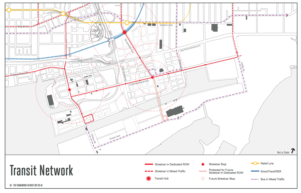
Start with the routes in this link. Also the Port Lands, at this link. And the Waterfront Transit from Lake Shore Blvd. West to Union Station, see this link. That's in addition the the 512 St. Clair extension to Jane Street or Scarlett Road.

26578-93189.png


993c-Waterfront_transit_TTC-_briefing_v11-01.png
 

Back
Top