News   Jan 07, 2025
 853     2 
News   Jan 07, 2025
 3.9K     14 
News   Jan 07, 2025
 519     1 

Transit Fantasy Maps

I see a lot of people pooh-pooh the western leg of the DRL, but at the same time demanding the eastern leg be overbuilt all the way to Steeles (exactly paralleling SmartTrack and the Yonge Line). Part of this comes, I think, from Steve Munro, who has lived and worked his entire life east of the Don Valley and seems to downplay or attack any transit project west of Spadina (e.g. WWLRT, Jane LRT, DRL west, ARL) as unnecessary but east of Yonge (DRL from CBD to his childhood home at Yonge/Eg, WELRT to abandoned industrial sites in the portlands, etc.) as critical.

Surely you'd agree that the RL east is more critical than the RL west, right?
 
Surely you'd agree that the RL east is more critical than the RL west, right?

Oh, definitely, not arguing that. It's just that I see people who talk about bringing the eastern leg up to Seneca at Finch before completing the south of Bloor U.

I think that people have a tendancy of viewing the line's sole purpose as relieving Yonge, so they design it as a parallel Yonge line that stops just west of union station, as though the yonge line was copied and shifted 5 km over. There are other purposes (providing service to shoulder areas, relieving streetcar congestion) that aren't met by ending it at University.

The DRL scheme that I dislike the most is the one that just stops at the foot of Bathurst at the rail corridor at a "Union West" terminus.
 
Very good points aquateam. I'd mention however that SmartTrack would connect with the DRL at Dufferin/Queen and it is minimum 15 minute frequencies, meaning likely much quicker in reality.

I still don't like the alignment along either Parkdale or Roncesvalles. If we are bringing it up to Bloor on the west side, the only proper alignment would be on Dufferin. That way we can revitalize Dufferin Mall and intensify the whole Dufferin corridor. But choosing Dufferin means passing up on Sunnyside hub which seems too good of an opportunity to pass up.

My favorite option in a world of unlimited $$$ is 'porque no los dos'. :)

So, you'd rather have relief line not interchange with the Lakeshore West GO line?
 
Last edited:
It would at a new interchange station at Sunnyside.

An alignment up Dufferin would not intersect with the rail corridor. I honesbtly don't think a "both" option would be feasible technically, financially, or politically. Unless you're looking at a King/Railway/Dufferin alignment, the turning radius from Queen to Dufferin would be too tight, and you wouldn't be able to fit in a station at the intersection.
 
Regarding the Beaches and southern Etobicoke, I had a crazy thought yesterday: what if we make the Queen streetcar a rocket route?? We can't run rocket bus services on streetcar routes because it's pretty much impossible to overtake a stopped streetcar. But a streetcar could overtake a stopped bus. So we would ran some parallel bus routes along Queen/Lakeshore, and where service is overlapped, the streetcar would make limited stops. For example:
- new local bus route from Dundas West or Lansdowne along Queen and up Kingston (Queen streetcar makes all stops east of Kingston).
- extend route 66 Park Lawn and 76 Royal York to Humber Lakeshore loop, and route 44 Kipling to Long Branch

I had some spare time yesterday, so I started making a map of this service pattern that you described, because I think it's a really great idea. The basic principle that I came up with after playing around with it is this:

-Implement the express service on both the Queen and King streetcars during rush hour.
-Implement 3 local bus routes: Long Branch to Humber Loop (serving Southern Etobicoke), Dundas West Stn to Neville Park via Roncesvalles and Queen, Dundas West Stn to Broadview Stn via Roncesvalles, King, and Broadview.

I decided to split up the Queen local bus into 2 routes for a couple reasons. Firstly, because the full 501 route is pretty long for a local bus, and 2 shorter routes would be easier to manage frequencies. Secondly, because it beefs up local service to Dundas West station, and randomly stopping at Roncesvalles is kind of weird.

The map isn't done yet, but I thought I'd get some comments on my changes. Again, props to reaperexpress for the idea. I think it's a great one.

There has to be a better option for a short-turn of the Lakeshore West bus route than at Humber Loop. Perhaps you could run it up the Kingsway to Jane to interchange with the subway there?
 
There has to be a better option for a short-turn of the Lakeshore West bus route than at Humber Loop. Perhaps you could run it up the Kingsway to Jane to interchange with the subway there?

That could work. I mainly just wanted to avoid running the buses on the Queensway section of the 501, since it's dedicated lanes there and already semi-express. A parallel bus route there would be redundant. I picked Humber Loop because it's a frequent short-turn location for the 501.
 
I had some spare time yesterday, so I started making a map of this service pattern that you described, because I think it's a really great idea. The basic principle that I came up with after playing around with it is this:

-Implement the express service on both the Queen and King streetcars during rush hour.
-Implement 3 local bus routes: Long Branch to Humber Loop (serving Southern Etobicoke), Dundas West Stn to Neville Park via Roncesvalles and Queen, Dundas West Stn to Broadview Stn via Roncesvalles, King, and Broadview.

I decided to split up the Queen local bus into 2 routes for a couple reasons. Firstly, because the full 501 route is pretty long for a local bus, and 2 shorter routes would be easier to manage frequencies. Secondly, because it beefs up local service to Dundas West station, and randomly stopping at Roncesvalles is kind of weird.

The map isn't done yet, but I thought I'd get some comments on my changes. Again, props to reaperexpress for the idea. I think it's a great one.

I'd totally forgotten about this. Your concept sounds pretty similar to what I had in mind, but I'll throw together a quick map over the next few hours so we can have a couple implementation styles to compare.
 
Here we go:

(Full size image)
15783088984_88fe494875_c.jpg
 
So here's what I came up with:

Queen%20Express%20Streetcar.jpg

Link: https://dl.dropboxusercontent.com/u/43869799/Queen Express Streetcar.jpg

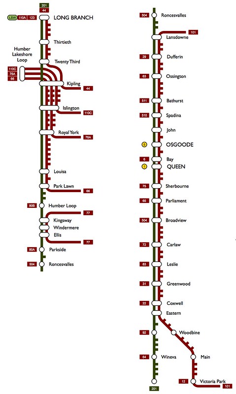
The red and orange routes are streetcars, the rest (aside from the subways, obviously) are supplementary bus routes. Rather than attaching unique route numbers, I figured that using the same number as the regular route, but attaching an "L" or an "E" onto the end would be easier for people to understand.

One thing that I really noticed when doing this map was how many streetcar stops there are in between what we would consider to be "major" streets. Cutting them out reduces the number of stops between Point A and Point B pretty substantially.
 
So here's what I came up with:

The red and orange routes are streetcars, the rest (aside from the subways, obviously) are supplementary bus routes. Rather than attaching unique route numbers, I figured that using the same number as the regular route, but attaching an "L" or an "E" onto the end would be easier for people to understand.

One thing that I really noticed when doing this map was how many streetcar stops there are in between what we would consider to be "major" streets. Cutting them out reduces the number of stops between Point A and Point B pretty substantially.

Nice map!

A couple comments:
- There can't be limited-stop services on Roncesvalles, because the street arrangement doesn't allow overtaking. I think the first stop north of Queen is the only one that has a bay.
- I don't think there's really a benefit in having express service east of Coxwell, because in that segment the route serves a local function. The demand is really dispersed, and the route isn't a through route to anywhere else at that point. I figured it'd make more sense to split up the routes and send one up Kingston, as you can see in my map.
 
Very nice map. I agree with reaper, I would send the bus route up Kingston to Eglinton. (Where it would meet Eglinton-Malvern LRT)

I wonder what the ridership numbers for those streetcar and bus lanes would be.
 
Good points guys, and nice map as well reaper! It's interesting how starting from the same basic concept can yield some pretty different results.

As for Roncesvalles, yes it's true that overtaking can't happen at stops, but in between stops the configuration is generally 4 lanes, isn't it? There really isn't another N-S corridor where that kind of service would work. Streetcar-only would work, but then it would need to stop at every stop, eliminating part of the express nature of it all.

The lack of express service east of Coxwell I can agree with, although I think east of Woodbine is probably better. I figure it could potentially overlap the Woodbine bus during peak periods.
 

Back
Top