News   Apr 24, 2024
 218     0 
News   Apr 23, 2024
 2.3K     5 
News   Apr 23, 2024
 618     0 

The Weather

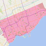
Apparently Brampton and Mississauga also had a tornado warning, but the risk dropped to just a severe thunderstorm.
There was a few minutes where I thought we were about to get one, as the wind got violent and the hail grew to bigger than marble sized.
 
Tornado watch you mean. Warning would mean that tornado has already touched down. I have never heard of a tornado in Mississauga or Brampton before. Has there been?
 
Tornado watch you mean. Warning would mean that tornado has already touched down. I have never heard of a tornado in Mississauga or Brampton before. Has there been?
I think a watch means that weather conditions may occur that could produce tornadoes, but a warning means conditions will occur (or are occurring) that could produce tornadoes.

No doubt Mississauga and Brampton have seen funnel clouds, but I'm not sure if any have ever touched down.
 
Tornado watch you mean. Warning would mean that tornado has already touched down. I have never heard of a tornado in Mississauga or Brampton before. Has there been?

I was only reporting what I've seen in the media. We've had tornado warnings before when there was no active tornado. A tornado warning can be issued when there is an active tornado, or sightings of funnel clouds, or if radar indicates a tornado is imminent.

http://www.mississauganews.com/news/article/34484--tornado-warning-downgraded
 
Special weather statement
Issued by Environment Canada Ontario region. 5:06 PM EDT Friday
7 August 2009.

Special weather statement issued for..
City of Toronto
Windsor - Essex - Chatham-Kent
Sarnia - Lambton
Elgin
London - Middlesex
Simcoe - Delhi - Norfolk
Dunnville - Caledonia - Haldimand
Oxford - Brant
Niagara
City of Hamilton
Halton - Peel
York - Durham
Huron - Perth
Waterloo - Wellington
Dufferin - Innisfil
Grey - Bruce
Barrie - Orillia - Midland.

Unsettled weather on Saturday followed by hot and humid air Sunday.

An approaching weather system is expected to bring showers and
isolated thunderstorms over southwestern Ontario Saturday morning and
spread northeast towards Mount Forest and the Grey-Bruce area during
the day. There is a chance that some of these thunderstorms may
become severe with heavy downpours and possibly gusty winds
especially on Saturday night as the system intensifies.
Some uncertainty remains as to the exact location of where these
showers and thunderstorms will occur. There is a risk that if the
thunderstorms remain in the same area significant rainfall may occur
and hence a severe thunderstorm warning may be issued.

In the wake of Saturday's unsettled weather, hot and humid air will
dominate over Southern Ontario on Sunday. Temperatures are
Expected to soar into the low to mid 30S over the southwest and into
the greater Toronto area. This is the stickiest weather we have yet
to experience this summer with humidex values in the low 40S possible
over southwestern Ontario. A humidex advisory will likely be issued
as Sunday draws near.
 
Batten down the hatches Urban Toronto!

City of Toronto
8:15 PM EDT Sunday 9 August 2009
Severe thunderstorm warning for
City of Toronto issued

A line of thunderstorms with intense lightning stretching from northern Huron county to near Lindsay is tracking southeast at 80 km/h.These thunderstorms may produce wind gusts to 100 km/h and large hail of 2 centimetres. These storms have a history of damaging winds.
This is a warning that severe thunderstorms are imminent or occurring in these regions. Remember some severe thunderstorms produce tornadoes..Listen for updated warnings. Emergency management Ontario recommends taking cover immediately when threatening weather approaches.
 
No wind where I am... but every building in the neighbourhood got hit atleast once by lightning.... and the CN Tower took a few very nice hits as well. (I'm at Maple Leaf Quay...)
 
Whatta' Storm!

Taken between 8:15 - 9:00pm facing the city and lake from downtown.
Easily one of the most active electrical storms I've seen in a long, long time. I saw several thousand strikes, often 6-10 strikes in 2 or 3 seconds and it continues to be just as active at 9:45pm although most activity seems to be happening down by the lake now (from my vantage point).

Click on the thumbnail to enlarge, then click again on the image for full size.

Menacing clouds around 8:15 -


Heavy rain moves in -


Lightening, 72 shots and I only managed to capture one lightening strike among dozens that hit the downtown buildings in the space of about half an hour -

 
Last edited:
A few years ago a very small and brief tornado tore the roof off a store on Dundas a few blocks west of Kipling.
 
Taken between 8:15 - 9:00pm facing the city and lake from downtown.
Easily one of the most active electrical storms I've seen in a long, long time. I saw several thousand strikes, often 6-10 strikes in 2 or 3 seconds and it continues to be just as active at 9:45pm although most activity seems to be happening down by the lake now (from my vantage point).

Click on the thumbnail to enlarge, then click again on the image for full size.

Menacing clouds around 8:15 -


Menacing? Maybe. The arrival of this storm was actually a thing of beauty. Many buildings were still picking up light from the sun as the dark tendrils of cloud slowly moved in, hanging down like talons. The contrast between the rich blue sky and the dark grey clouds looked like something right out of a fantasy story. You just couldn't take your eyes off of it.

The following lightning show was a beautiful display. Just fantastic to watch.

Thanks for the photos.
 
Daily Dose of Imagery has some great shots from last night's storm here...

http://wvs.topleftpixel.com/

lightning_storm_cn-tower_02.jpg
 
City of Toronto
1:23 PM EDT Monday 10 August 2009
Severe thunderstorm watch for
City of Toronto issued

Increasing potential for severe thunderstorms this afternoon into this evening.

This is an alert to the potential development of severe thunderstorms with torrential rain and damaging winds.
 

Back
Top