News   May 01, 2024
 16     0 
News   May 01, 2024
 236     0 
News   May 01, 2024
 855     0 

Roads: Ontario/GTA Highways Discussion

But stop goddamn removing the word busiest. Your just vandalizing the page.
I didn't remove the word busiest. I removed the word largest. You need to find a source that says it is the largest (or at least 2 sources, which each list the lengths for each city), not simply a list of highway numbers.

Also, I wouldn't advise calling other editors "retards" in edit comments. That will quickly lead to blocks. If you feel I am vandalizing the page, feel free to report me to WP:ANV.

Oh, hang on, just looked carefully. Now you deleted busiest. Even I didn't disagree with that! The only city close is Montreal, which might have more kilometres of highway, but none offhand have more than 6 lanes (hmm, maybe some of the 720 is 10 lanes ... but that's not much). Needs a reference, but I don't think anyone is disputing that.
 
Last edited:
I didn't remove the word busiest. I removed the word largest. You need to find a source that says it is the largest (or at least 2 sources, which each list the lengths for each city), not simply a list of highway numbers.

Also, I wouldn't advise calling other editors "retards" in edit comments. That will quickly lead to blocks. If you feel I am vandalizing the page, feel free to report me to WP:ANV.

Oh, hang on, just looked carefully. Now you deleted busiest. Even I didn't disagree with that! The only city close is Montreal, which might have more kilometres of highway, but none offhand have more than 6 lanes (hmm, maybe some of the 720 is 10 lanes ... but that's not much). Needs a reference, but I don't think anyone is disputing that.

Interesting, you're a wiki editor eh. I think a few other posters here are as well. Not sure how hard that is (or if it requires coding skills), but I'd like to try my hand at that one day.
 
Wiki markup language isn't difficult to learn.

I have edited Wikipedia for over a decade and am even featured in a Toronto Star article for my contributions to the Toronto Blue Jays article.

@nfitz , @DonValleyRainbow (Wikipedia username: Natural_RX), and @SimonP are also Wikipedians who frequent UT.
 
Speaking of Wikipedia. Users can be ridiculously strict. I wrote an Airport Road article that was deleted because it was mostly referenced from James Bow's travelogue rather than government or media sources. Three users voted for deletion and nobody voted to keep it.
 
Speaking of Wikipedia. Users can be ridiculously strict. I wrote an Airport Road article that was deleted because it was mostly referenced from James Bow's travelogue rather than government or media sources. Three users voted for deletion and nobody voted to keep it.
To be fair, it needs more sources, not just from James Bow. It also needs newspaper articles as well. Yes, Airport Road extends all the way to Stayner, Ontario.
 
Bit of an exaggeration there.

It was about 50 homes that were sandwiched between the railway and Lake Shore.

1956:
View attachment 116113

1961:
View attachment 116114
Very interesting! I've never seen an aerial view of the lower Parkdale area prior to the Gardiner going through, and I had not idea there were so many streets and homes in there. I count over 80, BTW, that came down south of the rail tracks.

There was also quite a bit of lake filling in what's now Marilyn Bell Park, and I assume that a lot of it probably came strait from the area excavated for Gardiner there. (There's also been a lot more since that 1961 photo.) With all the attention that lake filling gets in the TorontoHarbour area, I hadn't realized that this area has also had quite so much.

42
 
Very interesting! I've never seen an aerial view of the lower Parkdale area prior to the Gardiner going through, and I had not idea there were so many streets and homes in there. I count over 80, BTW, that came down south of the rail tracks.

There was also quite a bit of lake filling in what's now Marilyn Bell Park, and I assume that a lot of it probably came strait from the area excavated for Gardiner there. (There's also been a lot more since that 1961 photo.) With all the attention that lake filling gets in the Toronto Harbour area, I hadn't realized that this area has also had quite so much.

42
One of the 'alternate' newspapers/websites had an article on it some months back, and I too was transfixed at what was there, and now gone. I feel more than a little naive to think that the railcuttings let alone Queensway and Lake Shore were all naturally occurring features that had been pressed into use.

I'll see if I can find and link that article, it has wads of pics and detail, all exquisite...and frightening too. It's akin to a lobotomy being performed on a grand neighbourhood.

Edit to Add: Got it! That was a lucky Google, remembered the "lost streets of Parkdale" to find it:
The lost streets of South Parkdale
March 4, 2017 | By Chris Bateman
20170302-LostStreets-Aerial-600x494.jpg


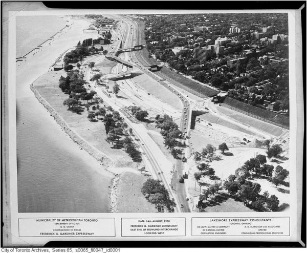
South Parkdale during construction of the Gardiner Expressway in August, 1958. Image: City of Toronto Archives, Fonds 220, Series 65, File 47.

No Toronto neighbourhood paid for the Gardiner Expressway quite like Parkdale.

Before construction of the lakefront highway in 1958, the land south of Springhurst Avenue and the rail tracks was just like the rest of Parkdale: residential, consisting of mostly detached homes on spacious lots.

At the time, Dunn and Jameson Avenues passed over the rail tracks south to the waterfront and a tangle of smaller streets such as Laburnam and Starr Avenues, Empress Crescent, and Hawthorne Terrace intersected them.

South Parkdale was distinct enough to have its own railway station near the present-day foot of Close Avenue.

The first major road to penetrate the neighbourhood was Lake Shore Boulevard, which snaked south of Exhibition Place along the waterfront toward the Humber River in the 1920s.

In South Parkdale, Lake Shore Boulevard was created by merging and widening a number of residential streets, including Laburnam Avenue and parts of Starr Avenue.

There are subtle clues to the existence of these old streets. Lake Shore Boulevard subtly winds in the area north of Marilyn Bell Park, mirroring the former the routes of these lost streets. [...continues with many newspaper clippings, photos and much detail...]
http://spacing.ca/toronto/2017/03/04/lost-streets-south-parkdale/
 
Last edited:
No point bemoaning the loss of what would be today $5M+ single family homes to connect downtown Toronto to the rest of the world (Gardiner/Lake Shore provides access between Airport & USA to downtown).
 
No point bemoaning the loss of what would be today $5M+ single family homes to connect downtown Toronto to the rest of the world (Gardiner/Lake Shore provides access between Airport & USA to downtown).

That's a massive over-exaggeration. While the Gardiner is a critical piece of infrastructure, Toronto was not some remote island with no roads in or out until the gardiner was built, "not connected to the rest of the world". There were, and still are, many other ways in/out of downtown.
 

Back
Top