News   Nov 22, 2024
 704     1 
News   Nov 22, 2024
 1.2K     5 
News   Nov 22, 2024
 3.3K     8 

Planned Sprawl in the GTA

The problem isn't so much sprawl as it is demand in one small geographic area. If this kind of development was spread out across all of Ontario, it wouldn't really be an issue. I like what Ontario is doing with the anti-sprawl policy, but from my understanding, it applies to all of Southern Ontario. I think it should be limited to the GTA/GTHA.
It doesn't The Growth Plan only effects the GGH. Ottawa, London, Brantford, Windsor, etc. are unaffected. The furthest it reaches is Peterborough, Barrie, Kitchener-Waterloo, and Niagara.
 
Issue is dumb development.

They build monster huge homes in brampton and they could easily built a townhouse development or 5-6 story apartment in the corners of intersections.

Really wasted a lot of land .
I would hazard a guess that there have been more townhouses built in Brampton in the last 5 years than homes that meet anyone's defintion of "monster" homes.......Brampton has had a tough time attracting any highrise condo development (market realities....many are approved....few built) so their only hope of achieving anything close to their density targets is townhomes....and they have been aggressively approving them and builders are building them.....and people are buying them.
 
Brampton's market issues with higher density is that their lowrise supply is cheap and abundant - which means that the pricepoint for multi family is too low to be profitable. Why buy a 2 bed condo for $400k if you can buy a 4 bed townhouse for $500k?

When Brampton runs out of developable greenfield land in about 15 years, that is when multi family will start selling.
 
Brampton's market issues with higher density is that their lowrise supply is cheap and abundant - which means that the pricepoint for multi family is too low to be profitable. Why buy a 2 bed condo for $400k if you can buy a 4 bed townhouse for $500k?

Historically, yes, that has been a big part in holding back condo development in Brampton.........

I don't think you can buy a 4-bedroom townhouse for that little in Brampton anymore.
Not sure anyone builds 4 bedroom townhomes in Brampton either.....but 3 bedroom townhomes in my 'hood range from $500k - $600k......I think you can buy lower in some other areas.........this has been a fairly recent blip upwards so, if it holds, there may be some good news on the horizon for those people who have approved sites that sale price was holding them back (of course it only works if their building costs have not risen at the same rate as the end price while they have been waiting).

EDIT: just scanned other areas, there is at least one 3 bedroom townhome (with a 2 bedroom suite in the basement ;) ) listed on MLS for $399,000....right around Hansen and Queen.

Bunch of older townhomes in the Bramalea and Queen area for sub $350k too.
 
Last edited:
Interesting that even in Mexico City, they have learned NOT to bow to the car.

Metro Cities: Mexio City's one-word fix for congestion
By changing one word in the city's parking policies, the largest city in North America has enacted one of the most progressive city-building tactics seen on the continent.

See link.


Earlier this month, Mexico City mayor Miguel Mancera led his city’s charge to change the rules for parking spaces and as a result flipped the script on how North America’s largest city will grow. Where developers were once required to include a minimum amount of parking, there is now a maximum in place. Go over your allowed number of spaces and you pay a fee to fund urban living.


MINIMUM: The old rules required developers to include one parking spot per 30 square metres of office space and similar rules for condos and shopping centres. This in a city where less than a third of residents own cars and there is a large subway system. A 2014 report showed parking was the fastest-growing land use in Mexico City.

MAXIMUM: Under the new rules, if a development in Mexico City’s downtown core goes more than 50 per cent above a maximum amount of parking spaces, the company must pay a fee. That money will be used to fund public transit and housing.
 
From The Star, at this link:

Trying to stop prime Ontario farmland from being ‘entombed forever’

Province’s new plan for Greater Golden Horseshoe would protect a continuous base of agricultural land.

rlfarm02jpg.jpg.size.custom.crop.872x650.jpg

Kim Empringham stands in a field of soy beans on her Stouffville, Ont., farm. The province is working to develop an agricultural system for the Greater Golden Horseshoe that will protect a continuous stretch of farmland through the region from development. (Richard Lautens / Toronto Star) | Order this photo

The whiz of cars on Kennedy Rd. cuts through the sound of crickets singing and wind rustling through soy fields at Empringham Farms.

The busy north-south corridor can be “dangerous” for farmers moving equipment between fields, said Kim Empringham, who farms 800 acres with her husband.

They’re based on 10 acres in Stouffville, but they farm cash crops — corn, wheat, and soy — in fields from Markham to Newmarket. It can take an hour by tractor to travel between them.

Some of their equipment is so wide, it crosses the yellow centre line on narrow commuter roads that weren’t built for farmers.

At times, they have to stop what they’re doing and wait for rush hour to end, because “it’s just not safe,” she said.

It’s a familiar challenge for farmers in the GTA, but things could change: Ontario is developing an agricultural system in the Greater Golden Horseshoe to enhance the area’s agri-food industry. The sector contributed $37.5 billion to Ontario’s GDP in 2016.

The agricultural system will protect a continuous base of prime farmlands from development, support the services and communities critical to the farm and food industry and ensure farmers’ needs are considered in future infrastructure planning.

“It’s about making sure that the sector, as a whole, can survive,” said Empringham, who also serves as the secretary-treasurer for the York Region Federation of Agriculture.

For Janet Horner, the executive director of the Golden Horseshoe Food and Farming Alliance, a simple rhetorical question almost says it all: “Don’t you want to eat?”

“Protecting our land, so we are able to be somewhat self-sufficient and food secure is important. If we could eat houses, that’s fine, but we can’t,” she said.

Protecting those prime lands for food productions becomes even more important as the population of the Greater Toronto Area is expected to grow by 42 per cent by 2041 and productive farmland is under threat from urban sprawl.

Most of Canada’s prime agricultural lands have already been lost, said Keith Currie, the president of the Ontario Federation of Agriculture.

Just look out from the top of the CN Tower. “It’s all the best farmland that’s been developed. Essentially it’s entombed forever under asphalt and cement,” he said.

While some agricultural lands are protected under current policies, even the Greenbelt Plan, which protected some farmland, including most of the land Empringham farms, left prime agricultural lands outside its bounds.

The urban development spreading outward from Toronto’s core has left farmland fragmented, at its worst creating farm islands in a suburban sea.

“When you’re surrounded by subdivisions, you can’t farm,” Empringham said.

The further your farm is from the other services and businesses that support you, the less competitive you are, she explained.

An agricultural system that ensures protection for a continuous tract of farmland creates an incentive for other agri-food businesses — vets, mills, equipment sellers and others — to expand or move into dense agricultural areas, boosting the economic outlook for farms.

For farmers, protected land can also give them confidence to plan long-term, without fear they’ll be squeezed out by development.

“We know we can stay here, so we can make improvements to the buildings, to the infrastructure that we’ve got here on our home base,” Empringham said.

Even if they sell, they know they’ll be selling to farmers, making investments in the farm worthwhile.

That’s not something she sees happening on the farms to the south, which fall outside the greenbelt in an area Empringham said is likely to become subdivisions at some point.

Developers in the region have a very different outlook. They are concerned the ministry isn’t considering pre-existing infrastructure and development approvals as it moves through the process of establishing an agricultural system.

“Remember 90 per cent of the housing that’s built is built by the private sector, so . . . if you want to provide that supply, the industry needs to have some certainty, not just in the future, but also some certainty with the approvals they currently have,” said Joe Vaccaro, CEO of the Ontario Home Builders’ Association.

A spokesperson for the Ministry of Agriculture, Food and Rural Affairs said the government is committed to managing growth, while protecting Ontario’s farmland and supporting economic viability.

The development of the agricultural system, which stems from the co-ordinated review of four land use plans and was recommended by the review panel chaired by David Crombie, is still in its early stages.

The provincial government has developed a draft map of the agricultural system, showing proposed protection boundaries as well as existing infrastructure and services.

The draft system map and implementation procedures are out for public consultation until Oct. 4. This concerns Empringham, who notes the summer and fall are a busy time for farmers.

For those that can spare two-and-half hours, there’s an online webinar, provided by the ministry, on Sept. 6, on the mapping and implementation procedures, for members of the agricultural community.

Once the public consultation is closed, the government will move forward with plans to update the map by the end of this year. Municipalities will have a couple years to refine it as part of their official plan reviews, which are required by July 2022.

Down the road, Horner, who is also a Mulmur Township councillor, expects there could be challenges between municipalities and the province over which lands should be protected for agriculture and which should be open to development.
 
Adding 20 minutes to your commute time could lead to dangerous consequences
  • The average commute time in the US is 50 minutes round trip, but some people spend far longer getting to and from work.
  • Researchers in England found adding an additional 20 minutes of commuting per day has the same negative effect on job satisfaction as receiving a 19% pay cut.
  • Overall, bus and train commuters report more dissatisfaction than those who walk or bike.
http://www.businessinsider.com/commuting-work-job-satisfaction-2017-10
 
You Care About the Subdivision Regulations, You Just Don't Know It (Yet)

See link.

Everybody’s heard of the zoning code. Sooner or later, a developer will submit an application to rezone land near your home or business, and everyone snaps to attention. Neighborhood advocates awaken from hibernation. Developers lawyer up. Because these proposals can be controversial, they frequently make the local news. As a result, the zoning code has become the Kim Kardashian of land regulations. Even if you can’t really explain what it does, you know it exists.

But zoning disputes typically only involve a few parcels of land at a time. So if you really care about the future of your city, you need to think bigger. You need to be thinking about the regulating documents that influence the design of entire neighborhoods. One of the most important? The local subdivision regulations.

Despite their power to shape cities, these regulations operate in almost complete obscurity. Even the most battle-hardened veteran of the zoning wars would be hard pressed to explain what the subdivision regulations do. Most folks don’t even know they exist.

Be a nerd. Save your city.

Basically, local subdivision regulations govern the division of land, which includes everything from a simple lot split to the creation of new neighborhoods from pastureland. Among other things, they establish rules for the creation of lots, blocks and streets, and provide for the establishment of easements, parks, and public rights-of-way.

Making modest, intelligent changes to this document can have enormous impacts because new neighborhoods tend to be mass-produced at a large scale. If your city hasn’t re-evaluated its subdivision regulations in a while, you’re probably still replicating bad ideas from the 1970’s — creating inflexible, and auto-centric places. If this is the case, it's time for a change...

1518594766202

At least one of these is fun. When subdivision regulations don't require connected streets, it's hard to get from place to place.

1518618727519

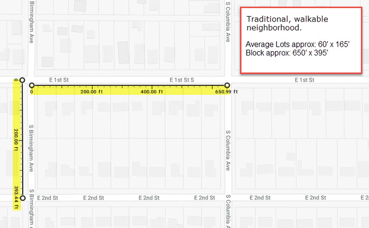
Example of a walkable neighborhood with short, connected blocks.

1518594120225

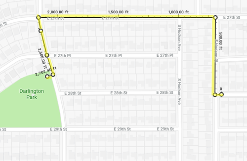
Long blocks and lack of connected streets drastically increase distances between destinations.

1518594195424

Just a simple walk to the park... Source: Google Maps

1518594324447

Comparison of fire station service areas within a 2.5-mile drive. Service area maps created by Daniel Jeffries.

1518594423863

How to calculate a connectivity index. (Source: Victoria Transportation Policy Institute)

1518597579111

Mysteries of cul-de-sac street design explained. (Source: 2015 International Fire Code)
 
4 Things For Transit Agencies to Remember in a World of Driverless Car Hype

See link.

IMG_1453.png


The threat that automated vehicles pose to public transit is a political threat. Pundits, politicians, and activists are now widely speculating that self-driving cars might “kill transit as we know it.” While some of these pronouncements are an honest attempt to account for the prospect of AVs in transportation planning, others are made in bad-faith – with real world consequences. Nashville’s transit referendum recently went down in flames, aided in at least some part by rhetoric from City Councilors proclaiming that Davidson County residents shouldn’t vote to invest in transit because “driverless buses will be ready in 12 months.”

In the midst of the hype, it’s essential for agencies to keep the following facts in mind (and up to advocates to remind them if they forget!):

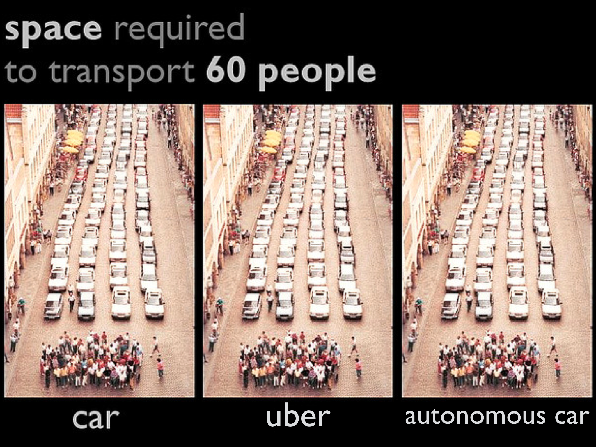
High-capacity transit makes the most efficient use of scarce urban space, making cities more affordable and sustainable. According to the National Association of City Transportation Officials, a general-purpose traffic lane can carry up to 1,600 people per hour in cars – far fewer than the 4,000-8,000 people per hour that an on-street bus lane or the 10,000-25,000 people per hour in dedicated right-of-way for light rail or bus rapid transit.

In other words, even if some trips in autonomous vehicles are shared (and sharing won’t happen unless cities incentivize it) transit will always offer more capacity. Many current debates that try to cast Uber-type services as “on demand transit” obscure the reality that they are actually 21st Century taxis. That matters, because dense cities can’t function well without affordable ways to move scores of people through the congested, bottlenecked networks in and around them.

The adoption timeframe for AV technology is long and uncertain—and if “autonomy” is possible, will take the longest in urban neighborhoods. Automakers, investors, and developers of autonomous technology are increasingly warning that the rollout of automated vehicles will be slow and piecemeal. Shahin Farshchi, an investor in AV start-ups and sensor companies, tells WIRED that “autonomous technology is currently where computing was in the 60s.” The CEO of Argo AI (which received $1 billion from Ford to work on self-driving software) has written that “those who think self-driving cars will be ubiquitous on city streets … in a few years are not well connected to the state of the art or committed to the safe deployment of the technology.”

One thing that technologists agree on is that the hallmarks of driving in city neighborhoods – things like faded lane markings, children playing in the street, and people walking their dogs, not to mention bad weather — are much harder for computers to deal with than open highways. Even if we reach a point where automated vehicles can operate on highways or in specially planned developments, it will be longer until they might be capable of operating in the chaotic streetscapes of busy business districts and neighborhoods —the places where transit should be and often is the most concentrated.

When testing new technology, agencies and city leaders should be clear about their goals and how they are defining success. Transit agencies are already facing pressure to enter into partnerships with transportation network companies and launch “microtransit” pilots; autonomous vehicles may be next (in fact, small driverless shuttles are already being tested in Houston, Buffalo, and Atlanta).

But testing new technology for global motor vehicle markets for its own sake is a job for universities, research agencies, and private R&D; transit agencies that experiment need clear theories about what new services can accomplish – like improved access, increased ridership, or safer streets – and a plan to measure results against those goals. Having strong metrics related to what transit accomplishes (like the number of jobs reachable within a 30-minute transit trip) helps defend transit from political attack and helps staff think about how new technology might or might not add value. And let’s be clear: politicians are mainly inviting such tests to their cities to hitch themselves to the veneer of cool tech.

Transit systems need to make themselves more competitive now. Forget AVs—cities are already facing an explosion of new transportation technologies. In particular, the exponential growth of transportation network companies has had an impact on cities, adding a new choice for riders who can afford it, and adding substantially to city traffic congestion, which slows down buses.

It’s no coincidence that cities and agencies on the front line of the onslaught of TNC traffic—like San Francisco, Seattle, and now New York City—have recognized the importance of making comprehensive efforts to make local bus service faster, more frequent and reliable, and more legible for riders. Bus network redesigns (including bus stop balancing), transit-only lanes, transit signal priority, and all-door boarding need to be high on the agenda for transit agencies. Taking a user experience cue from ridesharing companies and making payment as simple as the click of a button or the tap of a card is also paramount.

On the other end of the spectrum, Pittsburgh is considering building more roads for the sake of running robot shuttles – while forcing its transit riders to fight tooth and nail just to preserve existing bus service. The shuttle project is projected to cost between 4 and 10 million dollars, money which could instead be used to eliminate the burdensome cost of transfers for today’s riders. In Las Vegas, bus ridership is falling but the Mayor is proclaiming Las Vegas to be a “global leader in innovation and sustainability” after launching an on-demand shuttle system designed primarily for tourists.

Failing to improve bus and rail service today means consigning city residents to slow and unreliable transit, or to a loan payment on cars they can barely afford. The 21st century challenges of growth, inequality, and climate change demand action now, not waiting for new technology that may arrive at some indeterminate point in the future.
 

Back
Top