News   Jun 28, 2024
 3.8K     5 
News   Jun 28, 2024
 1.9K     2 
News   Jun 28, 2024
 654     1 

Miscellany Toronto Photographs: Then and Now

Another site showing "Then & Now"

"SpacingToronto" <http://spacing.ca/wire/> has just begun an exhibition (every Friday) of Toronto Then & Now creations.

Well that's quite original of Spacing.
 
From the book A SENSE OF URGENCY, Pg 222, Charles Booth, a former vp of Eaton's, is asked by Sir Joseph Flavalle, head of Simpson's,

"Charlie, why didn't you finish this building and move the business up to College Street?

"His answer was interesting."

"Sir Joseph, we didn't have the resources."


Regards,
J T
 
If the full proposal had been built:

eatonscollege.jpg

Did they change the plans before they started to build or they changed them after they finished the podium? Is it possible to finish the building one day?
 
Opppsss, I just realized that the building was supposed to be way bigger, down to Gerrard.
 
"Did they change the plans before they started to build or they changed them after they finished the podium?" QUOTE. Zeiss.


It was never stated in that book, maybe you should ask R Y Eaton. (LOL)

The book from which I have quoted is primarily in regard to Simpson's.

Regards,
J T
 
Is it possible to finish the building one day?

No, thank god. The original design "super-block" design was one of the most graceless, amateurish, provincial massings imagineable. Though the main facade is exquisite in its detailing, what would have been interesting would have been to complete the main facade down to Hayter, run a new north-south street through the block at the point the main building stopped on College and to have repeated the Yonge facade on the west elevation. A separate office tower could have risen on the SE corner of Bay and College. Given that the complex was more or less contemporary with Rockefeller Center, imagine if the site planning of the block had been done with that level of sophistication.

Original rendering:

Yonge_Street_north_of_Queen_Street_.jpg


Under construction, before the linking up of Carlton and College:

CarltonViewofCollegeStreetStoreUnde.jpg
 
Last edited:
Opppsss, I just realized that the building was supposed to be way bigger, down to Gerrard.

Umm..no..your render is correct; it was to have gone as far as Hayter. The 7-storey or so block that was built at Yonge and College represents one quarter of what would have been duplicated and built to fill out the 'square' ...as per your render. The city wasn't big enough back then probably would not have been able to sustain something that big if it were to occupy the entire block.
 
Continuing from "A SENSE OF URGENCY", by C L Burton:

"The first "mystery" block reputed to have been bought by Eaton's was the north-east corner of

Yonge and Carlton, the whole block from Carlton to Wood Street and from Yonge to Church."

"Before the war ended a second "mystery" block entered the picture, the entire south-west corner

of Yonge and College."

"... the purchaser of these two massive chunks of real estate was Eaton's."

"Out of a clear sky, at this juncture in all our affairs, our friends "across the road" one day offered

Simpson's the east mystey block-the Yonge-Carlton-Church block-if we, when they moved to College Street,

would bring our business up to the opposite corner."

"This, I believe, has never been made public before."

"The devil they knew was evidently to be prefered to the devil they didn't know."


Regards.
J T
 

the charioteer,

At top right of this photo is 1/2 of an open space. Gerrard runs across the north of it. It's what's left of the original Elizabeth Street Playground. The west end of Toronto Sick Childrens Hospital occupies this area now.
The school in the Then photos below is Hester How school.

http://www.toronto.ca/archives/rules/spdsfestival.htm

elizabethplaygroundandhesterhowscho.jpg


DSC_0019-1.jpg


fo1231_f1231_it0537.jpg


DSC_0017-3.jpg


hesterhowschoolelizabethstreet.jpg


DSC_0018-5.jpg


thecharioteer, if you have the time, can you consult your Goads maps to see if I have the exact modern day perspectives? I tried to get access to an online Goads, but the only one I could find are the resources hosted by Univ of TO and only available as far as I can tell to students and alumni. I went to York :) .
 
No, thank god. The original design "super-block" design was one of the most graceless, amateurish, provincial massings imagineable.

Either that, or (as I suspect) the rendering here is stocky, clumsy, and deceptive--I don't get the same provincial vibe from the classic non-aerial view of the proposal.
eatonscollege.jpg


Incidentally, you can see to its left along Yonge the row of 30s spec buildings N of College, made possible by the widening of this stretch of Yonge--they lasted into the 80s or so...
 
the charioteer,

At top right of this photo is 1/2 of an open space. Gerrard runs across the north of it. It's what's left of the original Elizabeth Street Playground. The west end of Toronto Sick Childrens Hospital occupies this area now.
The school in the Then photos below is Hester How school.

http://www.toronto.ca/archives/rules/spdsfestival.htm

elizabethplaygroundandhesterhowscho.jpg


DSC_0019-1.jpg


fo1231_f1231_it0537.jpg


DSC_0017-3.jpg


hesterhowschoolelizabethstreet.jpg


DSC_0018-5.jpg


thecharioteer, if you have the time, can you consult your Goads maps to see if I have the exact modern day perspectives? I tried to get access to an online Goads, but the only one I could find are the resources hosted by Univ of TO and only available as far as I can tell to students and alumni. I went to York :) .

Here's a view with a school labelled on axis with Walton Street (near the number D4 on the map). Is that the one? I've added a contemporary view from TO Maps (shows how Sick Kids became a super-block).

By the way, the easiest way to access the 1910 Goad maps is through the web-site Ontario History Quest (http://ohqdigit.tpl.toronto.on.ca/). Click on "maps" in the bottom field and it will take you to the maps.

elizabeth-1.jpg


elizabethwalton.jpg
 
Mustapha: I just realized that perhaps the reason I'm finding it hard to orient myself with regards to the playground, is because of the fact that in 1910, Gerrard Street had not yet been extended to University. The playground was probably built afterwards.

gerrardelizabeth-1-1.jpg
 
From the City's website http://www.toronto.ca/archives/rules/spdsfestival.htm:

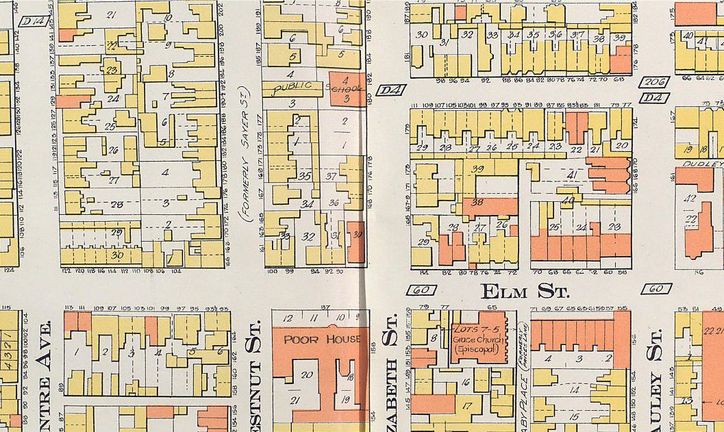
No area in early 20th-century Toronto was more congested, squalid, or infamous than "The Ward." Bounded by Yonge, Queen, College, and University, the Ward was also Toronto's pre-eminent foreign quarter. Lying within the shadow of City Hall, it was a highly visible alien presence in a predominantly Anglo-Celtic town, and often drew the attention of reformers, journalists, politicians, and bureaucrats.

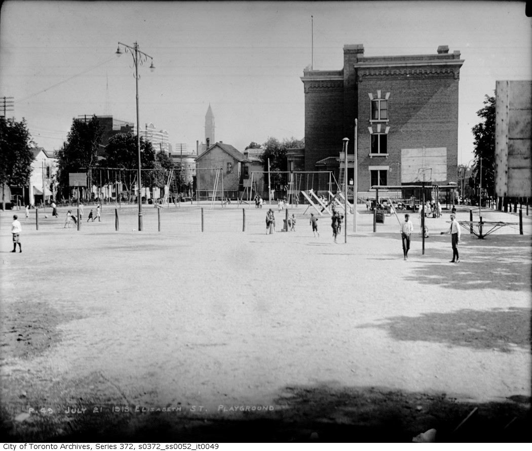
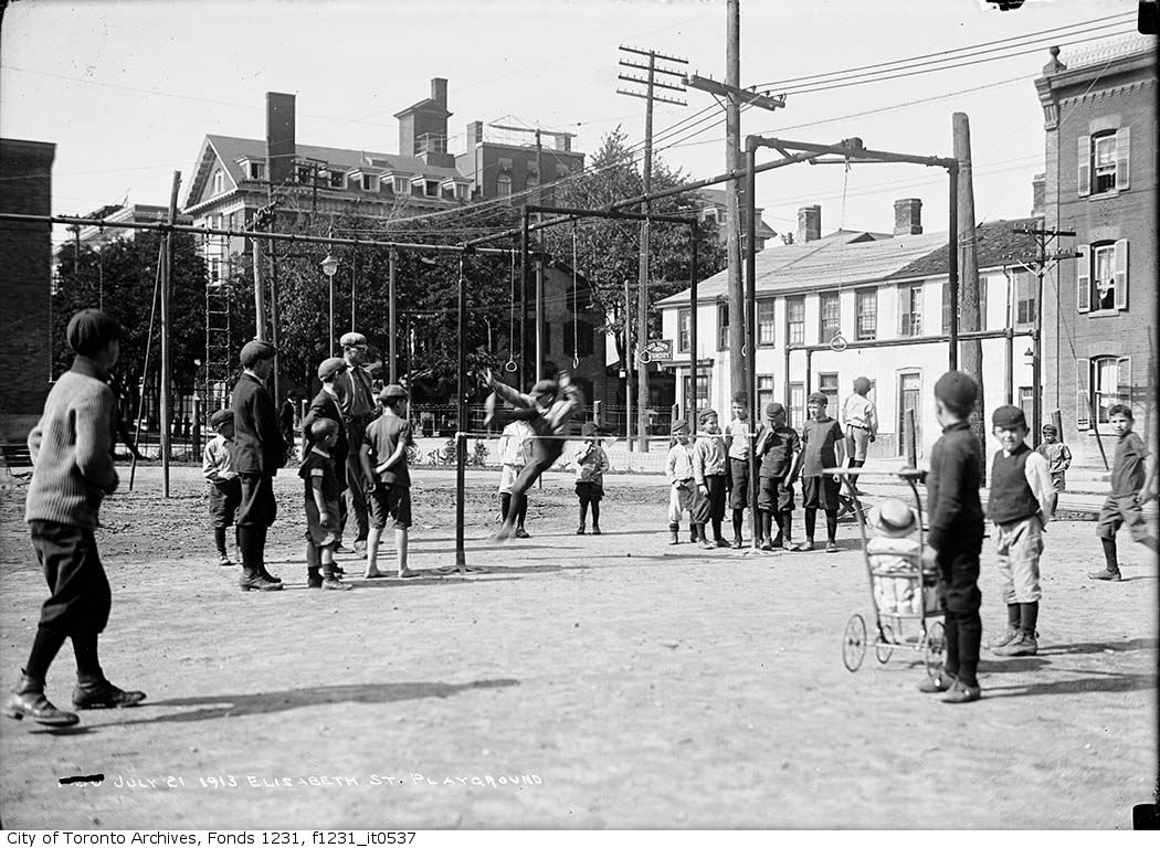
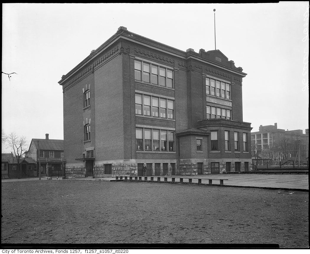
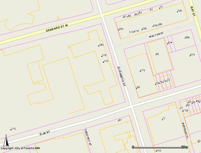
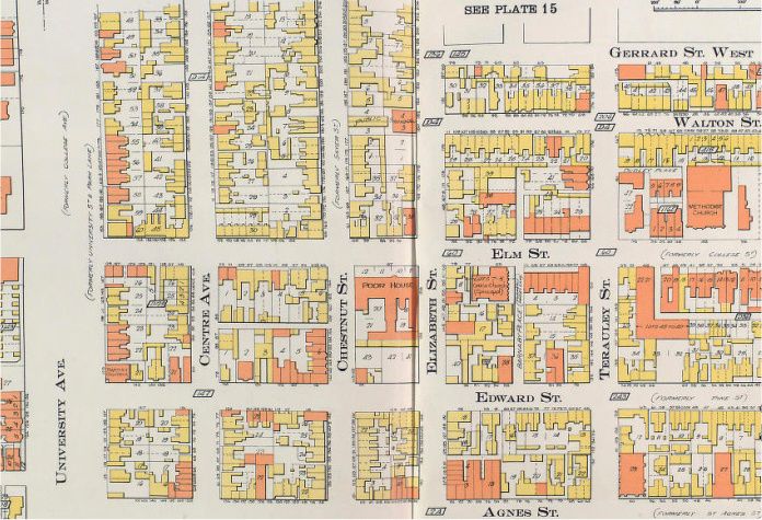
The Ward hosted many of Toronto's earliest child leisure facilities. The Board of Education's first supervised playground - the first in Canada operated by a public agency - opened at Elizabeth Street Public School in 1908. It was soon superseded by the Parks Department's first supervised playground, which opened at Elizabeth and Gerrard in 1911. Rinks and a children's slide were also maintained at the Elizabeth Playground (home of the "Lizzies") between 1911-12 and 1928-29.

Children's services were paramount at Central Neighbourhood House, a social settlement based in the Ward in 1911-28. The House organized clubs, classes, and clinics, and lobbied City Council for playground improvements. The House and other agencies also criticized Toronto's policy of suspending all recreation programs (and padlocking, patrolling, or removing all equipment) on Sundays.

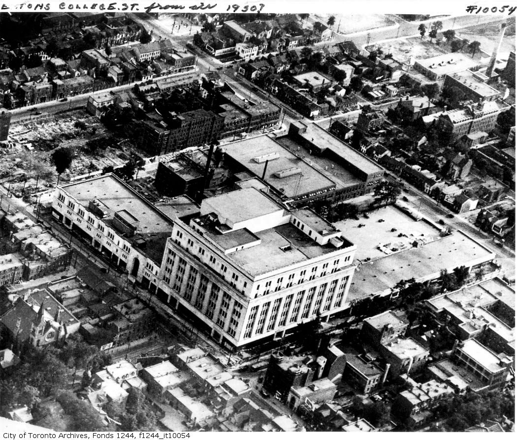
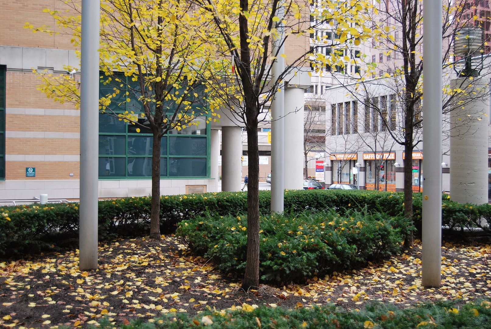
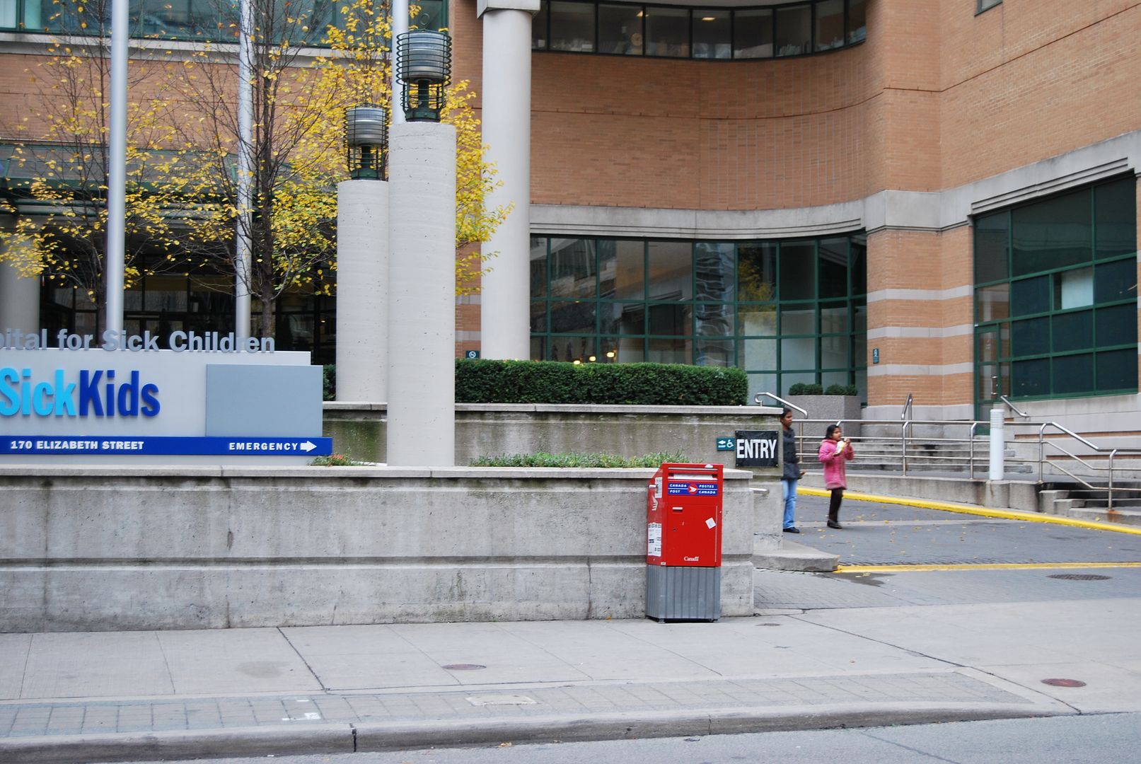
Much of the old Ward was cleared away in the late 1920s and early '30s. Toronto General Hospital purchased the Elizabeth Street Playground in 1928 and extended Gerrard through to University. The playground's south end was added to Hester How School. The Parks Department ran programs there for small children until the site was acquired by the Hospital for Sick Children.
 
The 'Lizzies' were quite the basketball players

Elizabeth Street Playground Juvenile Basketball — Playground, City and Canadian Champions - 1930
s0372_ss0052_it1407.jpg


Elizabeth Street Playground Juveniles — Playground, T & D, Ontario and Dominion Basketball Champions 1943-44
- some of these guys are probably still around
s0372_ss0052_it2116.jpg
 

Back
Top