News   Jul 09, 2024
 385     1 
News   Jul 09, 2024
 1.2K     2 
News   Jul 09, 2024
 501     0 

Historic photos from Toronto on this day

The second [photo] is the corner of Nassau and Spadina, looking south. I lived over the corner store for a number of years.

Ah, right, that offset bay window is still there! We walked past there on Sunday after the Kensington Car Free day - right about here Thanks, I've updated the geo-data and description.
 
June 1 We start back in 1917, 93 years ago, on a Friday in Riverdale park for a shot looking west, with the watchman and his house in the left corner:
f1231_it1895.jpg


From there we go to 1925, 85 years ago, to St. Michaels Cathedral,on the northeast corner of Shuter and Bond streets in the Garden District:
f1231_it0088.jpg


Then 71 years ago today, in 1939, we have two photos from the University of Toronto Soldiers tower and carillon, Hart House
thumbnailImage
thumbnailImage


A lot of photos for June 1st! 69 years ago, in 1941, we have an Armed forces personnel demonstration at wartime rally, Maple Leaf Gardens:
f1257_s1057_it7037.jpg


I wonder how many of them went into battle... I wonder how many of them made it home...

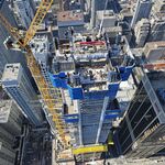
And finally we go way up to York University for the Scott Library under construction , 41 years ago, in 1969:
f1257_s1057_it6031.jpg


For links to all the full size photos, a map location of each photo, and other photos in the area, see the Toronto Historic Photos from June 1 webpage.
 
f1231_it1895.jpg


Now, there's a forgotten landmark--the Riverdale Park footbridge (almost appears as one of the first vehicular-to-pedestrian conversions, too). Wonder how long it lasted...
 
Now, there's a forgotten landmark--the Riverdale Park footbridge (almost appears as one of the first vehicular-to-pedestrian conversions, too). Wonder how long it lasted...
Hm, hard to tell with it in amongst the trees, but I don't see it obviously in this May 13th, 1922, photo, only 5 years later, but maybe it is there?
s0372_ss0052_it1009.jpg
 
June 2nd: Just one photo today, from 1937, 73 years ago today, also a Wednesday, to a leafy neighbourhood of nice looking houses across the street from the ravine that runs from Mount Pleasant Cemetery, under St. Clair, across to Mount Pleasant and further south. There are lots of photos of the area from the construction of the new St. Clair bridge, replacing the old Avoca Ave. bridge that was just behind and to the left of this photograph (Anna and DSC provided details and photos back on page 3 of this thread on the April 19th photos). See all the pictures from that area here.

s0372_ss0058_it1434.jpg


All these houses are long gone, with apartment buildings in their place.
 
Last edited:
Love that Scott Library photo. A million years ago I had a part time job in the library re-stacking books. I didn't last long.
 
Looks like a beautiful neighbourhood.
I assume that's what doomed those houses... I suspect the apartments/condos that are there now are rather nice too, with that view over the ravine, and really it is a great location for increased density, so close to the subway.

Love that Scott Library photo
Yeah, I don't seem to find as many photos in the City of Toronto Archives from after the 1950's, but the 60's and 70's are historic enough now....

June 3rd: Just one photo, from 102 years ago, to a flooded house on Toronto Island in 1908:
s0372_ss0041_it0506.jpg


I don't know the Island very well, so can't really say where 12 St. Andrews Avenue would have been... I assume it is close to St. Andrew by the Lake church, though, on the map around here?
 
June 4th: I think this is one of the oldest photos I've found with a specific date - Dunn Avenue looking south across Grand Trunk Railway crossing 111 years ago in 1899:

s0376_fl0002_it0086.jpg


For some reason there are a lot of photos of this railway crossing... some from 1904... the bridge in 1920... and so on. Check out the details and location for this photo here

One other photo from June 4th, this time of two women. From the City of Toronto Archive record: Item consists of one photograph. The woman on the right may be Lady Pellatt. The photo appeared in the Toronto World on Sunday, June 4, 1911, under the heading "Fascinating Women and Charming Gowns snapped at the Woodbine."

f1244_it0350.jpg


(Um, I've watched too much Monty Python... )
 
June 7th: Three is always talk here about how some areas have improved, other's have deteriorated, and I think it is safe to say that these two wonderful photos from 99 years ago, in 1911, fall under the category of an area that has deteriorated.

s0372_ss0058_it0051.jpg


s0372_ss0058_it0050.jpg


These two photos are on Wilton Cres. (now Dundas east) just west of Sherbourne Ave. A few trees remain, and maybe some original houses, but the street has a VERY different feeling to it now. In the distance in the 2nd photo is the All Saints Church.

Next we move to 1926, and two streetcar loops. Moore Park Loop, looking north, on Mount Pleasant, which is now the Loring/Wyle Parkette:
s0071_it4339.jpg


And then a loop we saw constructed, a few weeks ago: Rosedale Loop west side of Sherbourne Street, looking west
s0071_it4337.jpg


Finally, in 1939 we have two photos of 436 Wellesley Street looking rather run-down at the front and back:
s0372_ss0033_it0570.jpg


s0372_ss0033_it0571.jpg
 
June 8 A set of photos from 1920, 90 years ago, on a Tuesday in Trinity Bellwoods along Ossington:

for Looking south on Ossington down to Queen St
s0372_ss0058_it0877.jpg


Looking south down Ossington at Foxley St
thumbnailImage


Ossington Ave. south of Dundas St
thumbnailImage


Ossington Ave. at Harrison St
thumbnailImage


Ossington Ave. at Shannon St looking south
s0372_ss0058_it0882.jpg


For links to the photos, a map location of each photo, and other photos in the area, see the Toronto Historic Photos from June 8 webpage.
 
June 9th: Just one photo from today, back in 1911, of track construction on Wilton (Now Dudas Street east) at Victoria Ave. I assume we're looking west to Yonge Street?

s0372_ss0058_it0054.jpg


The building in the centre/left has a sign on top of some book company

It somewhat resembles the Texas Schoolbook Depository building - Oh my! What am I saying? - And overlooking a downtown square, too.
 
It somewhat resembles the Texas Schoolbook Depository building - Oh my! What am I saying? - And overlooking a downtown square, too.

Ha, you might be on to something here... A search on assassinations in 1911 turns up two possible connections:
  • Jack Ruby was born in 1911, only a few months before this photo was taken... is that his mother, who often wore white shirts and hats, walking away in our photo?
  • Pyotr Stolypin was assassinated in September 1911... some of the windows facing west might have a clear shot to the Kiev Opera House?

And here I thought this was just more TTC construction!
 

Back
Top