News   Dec 20, 2024
 3.2K     11 
News   Dec 20, 2024
 1.1K     3 
News   Dec 20, 2024
 2K     0 

Historic photos from Toronto on this day

May 13th: We start out at the intersection of Spadina and Harbord, with a bike, trolley, horse-drawn carriage, pedestrians, and not a car to be seen on a Saturday in 1911, 99 years ago:

s0372_ss0100_it0230.jpg


From there we'll head uptown, to Yonge Street at the Summerhill crossing 97 years ago, on Tuesday, May 13, 1913

f1231_it1311.jpg


Finally, we'll head back over to Riverdale Park around here, this time looking east across both sections of the park, up to Broadview, 88 years ago on Saturday, May 13, 1922

s0372_ss0052_it1009.jpg


You can find the links to the City of Toronto Archive records, as well as the locations in Toronto for these photos, on the May 13th Historic Toronto photos page, here.
 
Last edited:
May 14th: Two photos from the Toronto Island to start with, up around the north corner of the island at 74 Lakeshore Ave, 96 years ago back in 1914:

s0372_ss0052_it0329.jpg


s0372_ss0052_it0330.jpg


Then to 1917, to the back of 41 Huron Street, for the completion of the stone wall. I missed posting it here at the time, but you can see the wall and roof partially done, back on May 8th

s0372_ss0001_it0262.jpg


And here's inside:
s0372_ss0001_it0263.jpg


Then on to larger scale construction, on May 14, 1925, looking east on Dupont from Bathurst at Albany Ave, with many of the houses still there now:
s0071_it3761.jpg


And finally St. Clair Ave west, between Prospect Cemetery on our right, and Earlscourt Park on the left:
s0071_it8549.jpg


Links to the City of Toronto Archive records for all these entries, as well as the locations, are available here.
 
I presume that tall edifice in the back of of the St Clair shop is the former Gunns meat plant--boy, was it big...
 
May 15th: We start back 99 years ago, in 1911, at the corner of Spadina and Adelaide, with a very familiar style to the Coca-Cola sign:

s0372_ss0058_it0037.jpg


Then we move to 97 years ago, to 1913 and Rosedale Lane. There looks to be a bit of a ravine on the left side of the first photo, and billboards in the second one next to a taller building, but I'm note sure where these photos are from... somewhere along Yonge Street?

s0372_ss0032_it0190.jpg


s0372_ss0032_it0191.jpg


Here's the May 15th link which includes the City of Toronto Archive records, and the map locations.
 
Then we move to 97 years ago, to 1913 and Rosedale Lane. There looks to be a bit of a ravine on the left side of the first photo, and billboards in the second one next to a taller building, but I'm note sure where these photos are from... somewhere along Yonge Street?

Yes, basically where Fellowship Towers is now. Rosedale Lane, later Gibsons Lane went down the hill in a northeast direction to meet up with Rosedale Valley Drive/Road. First picture has houses on Cluny or Rosedale Rd in the background, while the billboard in the second picture is facing Yonge and some of those buildings might be the ones that are still there at 885-889 Yonge.
 
Last edited:
Thanks Anna, that makes sense!

May 16th: Here's a shot of Conger Lehigh Coal Co - looking northeast from 889 Gerrard Street back in 1930, 80 years ago. Like a lot of older photos, it is interesting to see so many kids about!

s0372_ss0029_it0020.jpg


Speaking of kids, they weren't just running free on the streets, here's three photos from 1939, 71 years ago, from the Art Gallery of Toronto (at the time) of children's art:

s0372_ss0002_it0217.jpg


s0372_ss0002_it0218.jpg


s0372_ss0002_it0216.jpg


And now, time for something completely different! Most of the photos I've added in this thread are from the City of Toronto Archives online collection, or the Toronto Public library, but elsewhere in this forum someone mentioned the Flickr user 'collations' - Patrick Cummins, and his wonderful collection of photos from around Toronto over the last 30 years or so. I haven't added many of his photos, and he tends to have a LOT of photos, but here's just one example - Bloor Street east of Spadina, 6 years ago in 2004:

4220301467_03974a5271_b.jpg


( As always, links to the originals, as well as the map locations are available here. )
 
May 17th: There are a number of sets of photos in the Toronto Archives with the photographer making their way along a street - today we're heading along St. Clair avenue back in 1935, 75 years ago today:

In the east, we'll start at Deer Park Crescent, looking east towards Yonge Street:
s0071_it10868.jpg


Then one block west, looking west this time, at Oriole Road, across Avenue Road to the Timothy Eaton Memorial Church:

s0071_it10867.jpg


We'll continue on to look west from Spadina Road (check out the map for pictures of the St. Clair reservoir being built, behind us, and the ravine ahead of us being filled in, not to mention the garbage dump):
s0071_it10862.jpg


A bit further along takes us to 'Wells Hill' which no longer exhists, looking east:

s0071_it10861.jpg


Finally we get to Bathurst St. and look back at the ravine and church tower:
s0071_it10860.jpg


I'm not sure if the gate on the left, at the north-east corner is Robert John Fleming's home

You can see the locations and links to the City of Toronto Archives on the May 17th historic Calendar entry.
 
Last edited:
May 18th: I'm not sure how far back I consider 'historic', but here are three more excellent shots from Patrick Cummins, this time from 1981, which is ( I'm afraid to say ) already 29 years ago!

We'll star along eastern Avenue (jump to his Flickr stream and move to the right to see more photos from the set):

4544645046_1b15c056d5_b.jpg


Then down to the Don Lands and the Canary Restaurant on Cherry Street (zoom in here on the map for more photos of the famous restaurant):

4519023679_235840f1c1_b.jpg


Then finally just a bit further south, of Front St. to "One of the last originally residential structures left in what was at one time a residential neighbourhood:"
4519666126_141f14186e_b.jpg
 
Can't let the day go by without posting this one, described in the Archives as follows:

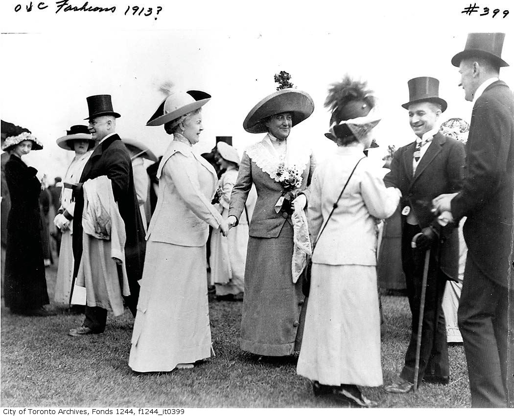
"Item consists of one photograph showing members of the Society of Woodbine Races, May 18, exact year unknown. Left to right: Justice Riddell, Mrs. Riddell, Mrs. Frank MacKelcan, Mrs. Agnes Dunlop, Mr. Charles Cranyn, Mr. Arthur Colville."

f1244_it0399.jpg
 
Last edited:
Thanks for the additions. Interesting to see that the the building on the north-east corner of Yonge and Adelaide remains, with the fancy top removed.

May 19th: We have the best, and worst of times for today. First 1914, 96 years ago down at the CNE. I feel like I should know which building this is, but I don't... anyone?
s0372_ss0052_it0332.jpg


And then from a fancy public building with rows of flowers out front, to, well, an old toilet at 113 Strachan Ave. in 1939, 71 years ago
s0372_ss0033_it0566.jpg


s0372_ss0033_it0565.jpg


I guess in those days you didn't pass up having your photo taken. I'm not sure what the neighbourhood was like backthen, but we're not far from the Queen Street Mental Health institute, and the old Central Prison, on King St. West near Strachan Avenue.
 
1914, 96 years ago down at the CNE. I feel like I should know which building this is, but I don't... anyone?
s0372_ss0052_it0332.jpg


That was known as the Horticulture Building but, in recent years, has served other purposes.
 

Back
Top