


Richard White
Senior Member
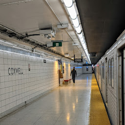
But what factor involving side street looping inhibits service?
They tie up traffic laying over on the sidestreets.
|
|
|
But what factor involving side street looping inhibits service?
But if scheduling is done correctly, there is no reason they should be laying over on said sidestreets. If there's space to store at least 1 streetcar at Coxwell, layovers on side streets will barely happen and if there is room for 2 streetcars, theoretically, bunching should never happen at the terminals, again, because frequencies would be so low for a streetcar line, and because traffic wouldn't severely affect the schedules of the cars.They tie up traffic laying over on the sidestreets.
Try again but with streetcar minimum curve radii and somewhere to put an accessible platform. That lane you are putting the Flexity down is maybe 5 meters wide even if you could get the Flexity to turn into it..
I would just loop it like this:
Space is a concern but the station can be easily modified to fit the 30 meter beast.
They tie up traffic laying over on the sidestreets.
T%he exit route you have chosen is the empty space because it is directly over the subway tracks. That's why it is unused. Are you sure they can actually build anything top of that? It been a while, but I also recall there being a grade change here too which would be a hindrance..
I would just loop it like this:
View attachment 203986
Space is a concern but the station can be easily modified to fit the 30 meter beast.
I don't have access to any of the engineering drawings or material properties, so no structural analysis on the entire station can be done. At this point, I'm just noting that there is space at the station for a streetcar line, but the station's bus terminal would require some modifications to enable for proper turning radii and fitting of Flexities. Space is constrained, yes, so the routing I proposed may not work, but those issues can be mitigated through another routing (which may include some expropriation). In terms of structural strengthening, if the line does indeed go over the subway, it might be necessary depending on the route one takes, but there's no way to consider that now when we don't have access to the data necessary to complete the structural analysis.T%he exit route you have chosen is the empty space because it is directly over the subway tracks. That's why it is unused. Are you sure they can actually build anything top of that? It been a while, but I also recall there being a grade change here too which would be a hindrance.
I measured the turn radius, it fits, but barely (I'm not sure of ArcGIS' accuracy here, but I presume it's within +-1m. Modifying the layout for it to fit there wouldn't be particularly challenging assuming it does reach the upper limit).Try again but with streetcar minimum curve radii and somewhere to put an accessible platform. That lane you are putting the Flexity down is maybe 5 meters wide even if you could get the Flexity to turn into it.
For the number of spaces involved, Green P lot would probably just get the predictable complaints from nearby traders rather than the War on the Car soldiers. I would have converted part of Danforth Garage (where the cops are going) to a Green P and put something in that space providing Danforth frontage to the subway. The bus terminal is presumably protected which limits some options there.
I think the Coxwell loop issue has really gotten over complicated by the streetcar expansion report wanting something underground. The dimensions of the existing station aren't ideal, but look doable in a pinch. That said, remember that there would only be one bus platform needed after restoring a Coxwell streetcar; if we sacrifice the ability for buses to pass each other in the loop and use the Green P lot it gets reasonably comfortable. There's a full 60 meters available between the Danforth frontage and Strathmore, which I suspect would allow a right off Strathmore and a north/south platform at about the mezzanine level before turning right onto Danforth. Even if there's enough vertical distance involved (which I don't have measurements of) to make that an unreasonably steep transition, an on street stop in the Danforth curb lane could fit a pair of cars albeit by putting the streetcars outside the fair paid zone.
The Danforth frontage is also fairly simple so long as the connection is made to the south end of the mezzanine. It also looks to me like there's enough space to move Danforth Division into, although I have yet to see site plans for the police division...
View attachment 204563
 www.facebook.com


The city is doing work on the water lines on itWhat on earth is going on on Dundas St? They seem to have just given up on it at this point. Buses have been a big mess as the 505 replacement.
The city is doing work on the water lines on it