News   Apr 30, 2024
 140     0 
News   Apr 29, 2024
 1.6K     0 
News   Apr 29, 2024
 1K     1 

TTC: Other Items (catch all)


Question of the day given the new Line 2 Train maps, what will Line 1 get?

I think everyone has been expecting this for a long time as we add more and more lines and it becomes infeasible to have all the map displayed above the doors,.
I don't get them and I think they are very unhelpful if you don't know the system at all. Ther are may times when I have helped a tourist to know which way to go on trains by using the map.
 
Hey everyone,

I was just at St George southbound and saw a flashing green signal (see below). I've heard of flashing red for grade timing but never flashing green.

Anyone know what this indicates?

 
Hey everyone,

I was just at St George southbound and saw a flashing green signal (see below). I've heard of flashing red for grade timing but never flashing green.

Anyone know what this indicates?

I would say its a sort of indicator for drivers that the track ahead is clear. Since that section of the line now runs ATC from St.George to the next station there are no signals (except at crossings). Those flashing Greens act as a sort of "Ok to Proceed" signal telling the driver he/she can close the doors and engage the ATO system. I would guess that in the event of a delay (intentional or not) the signal will display red to telling the driver to hold until given a green signal.
 
I would say its a sort of indicator for drivers that the track ahead is clear. Since that section of the line now runs ATC from St.George to the next station there are no signals (except at crossings). Those flashing Greens act as a sort of "Ok to Proceed" signal telling the driver he/she can close the doors and engage the ATO system.

I agree. The alternative is the solid red signal which means ATC system has determined the way ahead isn't clear yet so wait at the platform with doors open as the train won't be proceeding yet anyway.
 
I would say its a sort of indicator for drivers that the track ahead is clear. Since that section of the line now runs ATC from St.George to the next station there are no signals (except at crossings). Those flashing Greens act as a sort of "Ok to Proceed" signal telling the driver he/she can close the doors and engage the ATO system. I would guess that in the event of a delay (intentional or not) the signal will display red to telling the driver to hold until given a green signal.

This is correct. Even though the ATC system will automatically calculate the safe distances and speeds with regards to the track configuration and the position of trains ahead, there are still wayside signals at all interlockings as an added measure of safety. All they are used for now is to notify the operator of route and clearance through the interlocking.

Also note that the signals used at interlockings are far simplified compared to the old system. There now is a single-headed three-aspect signal at that location, versus the two-headed, three-plus-aspect signal that used to exist.

Dan
 
I don't get them and I think they are very unhelpful if you don't know the system at all. Ther are may times when I have helped a tourist to know which way to go on trains by using the map.

There will always be the new system map below these to reference.

DzULt3bWsAYGy1M.jpg
 
I don't get them and I think they are very unhelpful if you don't know the system at all. Ther are may times when I have helped a tourist to know which way to go on trains by using the map.

London has these for every line and it works fine. Their system is so large it is impossible to display it all on one map.

It will be fine.
 
In theory - I haven't spotted those new maps in great numbers yet ... wouldn't surprise me at all, if they start taking out the 4 existing maps in each car above the door, before they've put in 4 system maps!

Agreed, I was just in a crowded Line 2 train for the first time since they installed the new maps and there was only one system map on the wall, way down at the other end of the car. If I needed to see it there's no way I could have done so. Every pair of doorways needs a system map, just like every pair of doorway used to have a full subway map.

On the map itself, I think they should really show a little stub of Line 1 to show how it intersects with Line 2. This is important because we don't want to portray St. George and Spadina as equally-convenient transfer points.
 
If I needed to see it there's no way I could have done so.
It just dawned on me...the horror....you, I and most everyone in these forums knows how to read a map...but are we the odd ones out? Seriously, once you start asking around, the majority of folks haven't a clue how to read one. Some can't even follow the instructions of a GPS direction finder.

Sometimes we forget just how 'Old School' we are, even the younger ones that 'get it'. But wait, there's an app for that!

Edit to Add: I've just made a pretty outlandish statement, so thought I'd best Google...and sure enough:
Most under-25s can't read a map because they rely on sat-navs
Over two-thirds of under-25s are reduced to dribbling wrecks when confronted with paper maps, a survey conducted by MyVoucherCodes has revealed.
OCTOBER 10, 2013 1:40 AM PDT
[...]
https://www.cnet.com/roadshow/news/most-under-25s-cant-read-a-map-because-they-rely-on-sat-navs/

That was over five years ago. Guaranteed it's gotten worse...
 
Agreed, I was just in a crowded Line 2 train for the first time since they installed the new maps and there was only one system map on the wall, way down at the other end of the car. If I needed to see it there's no way I could have done so. Every pair of doorways needs a system map, just like every pair of doorway used to have a full subway map.

On the map itself, I think they should really show a little stub of Line 1 to show how it intersects with Line 2. This is important because we don't want to portray St. George and Spadina as equally-convenient transfer points.

Exactly, roll them out all at once next to and above every door. Not piecemeal. As for the line map. Brilliant and a long time coming, but agreed a little tick that shows the intersecting line could improve it.
 
Pretty sure the contractors are laughing their way to the bank.

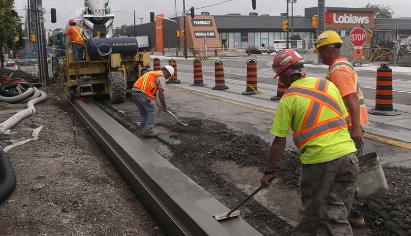
TTC tearing up Leslieville intersection for third time in 6 years
In 2013, TTC first tore out the tracks at Queen and Leslie Streets to upgrade them for new streetcars, which would be housed at the TTC’s nearby Leslie Barns. The work was supposed to be done in fall 2014. That was pushed to spring 2015, but that deadline also came and went due to errors by the construction company.

Information gathered at the construction site indicates that the current fix might not last. The TTC says it’s replacing the broken concrete with asphalt – something the source warns may only last a few years.
In May 2015, the TTC discovered that contractor, Pomerlau Construction, had improperly laid the track’s concrete foundation and installed the tracks nine inches too high, delaying the project by several months.

The cost also skyrocketed: From an initial estimate of $14 million, to $105 million when the intersection re-opened in August 2015.

 
Pretty sure the contractors are laughing their way to the bank.
They didn't get paid for the second time (which was in days of them doing it the first time - so still mobed), as it was their error.

I can't see how the contractor would be laughing - especially if it turns out they are at fault. Crying is more likely if it turns out to be a warranty repair!
 
  • Like
Reactions: DSC

Back
Top