News   Jul 15, 2024
 436     3 
News   Jul 15, 2024
 580     0 
News   Jul 15, 2024
 569     0 

TTC Cartography, Signage, and Wayfinding

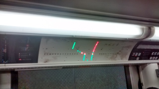
This doesn't really make sense. Look at the line map. From York Mills to Bellamy, all the dots are green. From Markham Road to UofT, all the dots are white. It says that the 95E runs express from York Mills station to Markham Road then all stops to UofT, which leads me to believe that green dots = no stop, and white dots = stops.

That is indeed consistent with the wordy text on the left side. This map was definitely not tested!

I guess you missed where right above the small print they have a picture of a green dot with EXPRESS STOP written next to it. It also says that between Yonge and Markham it stops where indicated (ie: the express stops). To confirm, on the route description page:

These buses operate from York Mills Station via east on York Mills Road, southeast on Parkwoods Village Drive, east on Ellesmere Road, and southeast on Military Trail to University of Toronto at Scarborough Loop. Eastbound 95E buses operate EXPRESS from York Mills Station to Markham Road, stopping only at Bayview Avenue, Leslie Street, Don Mills Road, Valley Woods Road, Victoria Park Avenue, Pharmacy Avenue, Warden Avenue, Birchmount Avenue, Kennedy Road, Midland Avenue, Brimley Road, McCowan Road and Bellamy Road; 95E buses then operate LOCAL from Markham Road to University of Toronto at Scarborough Loop.
 
I guess you missed where right above the small print they have a picture of a green dot with EXPRESS STOP written next to it. It also says that between Yonge and Markham it stops where indicated (ie: the express stops). To confirm, on the route description page:
Oh my, now I think your interpretation is correct. I'm not sure this could be made any more confusing.
 
I guess you missed where right above the small print they have a picture of a green dot with EXPRESS STOP written next to it. It also says that between Yonge and Markham it stops where indicated (ie: the express stops). To confirm, on the route description page:

These buses operate from York Mills Station via east on York Mills Road, southeast on Parkwoods Village Drive, east on Ellesmere Road, and southeast on Military Trail to University of Toronto at Scarborough Loop. Eastbound 95E buses operate EXPRESS from York Mills Station to Markham Road, stopping only at Bayview Avenue, Leslie Street, Don Mills Road, Valley Woods Road, Victoria Park Avenue, Pharmacy Avenue, Warden Avenue, Birchmount Avenue, Kennedy Road, Midland Avenue, Brimley Road, McCowan Road and Bellamy Road; 95E buses then operate LOCAL from Markham Road to University of Toronto at Scarborough Loop.
I guess I did miss that, and it perfectly illustrates how confusing this line map is.
 
So when a group of people who use the TTC and are interested in these maps can't figure it out, do they think someone new to the city is going to be able to use them successfully?
 
I'll give someone $10 to try and decipher this map out. Seriously, what in the planet are they doing?

TTC steeles map.jpg
 

Attachments

  • TTC steeles map.jpg
    TTC steeles map.jpg
    95.2 KB · Views: 914
The dotted green line make 60F look like a local service with the white dots the stops along the way. The 353 looks like it only has a stop at Yonge Street and Village Gate. The 60D and 60B looks like an express line only becoming local after Martin Grove Road.

Not of course, until one reads the legend.
 
Well, step #1 is to figure out what the difference is among:
  • Frequent Service
  • Regular Service
  • Limited Service
  • Express Limited Service
And who knew there was a transit agency called Züm?

The seemingly nested loops are also a nice touch for extra confusion!
 
Pretty confusing. I like the black dot in space that is labelled "Finch Terminal".

The map makes it look like the line skips it, and you are forced to watch your bus pass it by.
 
The new maps are a complete mess. It's like they hired someone who had never seen a map before.

A few quick questions for the map below:
- Where does 29D terminate? It's shown as terminating at Wilson, Bloor, and Dufferin Loop.
- Where do I get off the bus to connect to the Bloor-Danforth subway? Looks to me that the station is equidistant from Bloor and Wallace.
- It says there's "Connecting GTA Transit Service" for GO Transit. Where? Somewhere around Davenport, it seems.

(At least they considered some of the feedback I sent them before. The original version didn't even have 29A, which is the branch with the most service on Dufferin!)

029mapPanam.gif
 
Today well I was on the Younge Line (line 1) I saw one of the maps missing from above a door so I got a picture. From the looks of it they have lights in place for the SRT and the extension of the Spadina line
.
19698242048_a055456525_z_d.jpg
 
That whole approach with physical lights seems absurdly obsolete to me. I suppose the system changes so infrequently that this is actually more cost effective than LCD screens, but it looks so antiquated.
 
That whole approach with physical lights seems absurdly obsolete to me. I suppose the system changes so infrequently that this is actually more cost effective than LCD screens, but it looks so antiquated.
True, although there are also LCD screens that don't seem to do too much other than display the TTC logo.

Now to go back and pick on the map from Finch some more…
I'm particularly curious about the text below the Finch station which lists, presumably connections as
97B, C, F (n.b.) 125 199
This is particularly puzzling. First off, n.b. might take some puzzling. Is it nota bene? I presume it's northbound. Does it apply to B, C, & F, or just F? And why would only a northbound bus stop here?
 
Compare the (new) map for the 60 Steeles West (above) with the (old) map for the 53 Steeles East.
It might not be the gold standard for transit signage, but the old map is far more understandable than the previous one. I think part of it is that if you're getting to more than a few branches of the same bus number any map is bound to be confusing.
 
That whole approach with physical lights seems absurdly obsolete to me. I suppose the system changes so infrequently that this is actually more cost effective than LCD screens, but it looks so antiquated.
I don't know, the orange bulbs for the interchanges are already severely worn out on most trains I see as they are always on for reasons unknown — the interchanges are pretty easy to see on the map, I really don't think they need to be a different colour.

They really should've gone with a system similar to NYC that lists the next few stops and the terminal station and then put a full train system map next to the door in the advertising spot.
 

Back
Top