News   Nov 04, 2024
 529     0 
News   Nov 04, 2024
 762     5 
News   Nov 04, 2024
 956     1 

Transit Fantasy Maps

I transfer with kids all the time. Not sure the big deal. Two 10-minute trips with a kid is often easier than one 20-minute trip as it breaks up the journey, and gets them on their feet.

I certainly don't see what kids have to do with the discussion about transfers any more than anyone else. And I'm really not sure why this is being discussed here in a fantasy map thread.

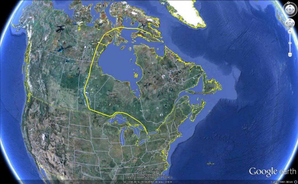
How about some nice maps showing the Yonge line going to Iqaluit?

I guess I just don't have your mad skills then.
 
I guess I just don't have your mad skills then.
I have no idea what that even means.

Now, I don't use a stroller ... never understand why anyone would voluntarily take one on transit. It's far easier to carry the smaller ones and make the ones that can walk, walk. Now if one has twins I can see it ... but often I am seeing a perfectly capable of walking 2-year old in a stroller - and often the kid walking and the stroller carrying what should simply be in a knapsack.
 
fine:

iqualiut_zps065aed24.jpg
 
You might be right, but I think that is a better candidate for the bloor line to be extended to. maybe through route it with the Montreal Green line.
 
Something of a fantasy map.
hhwpkkH.jpg

There are five major components to this.

...
2.) DRL: I've opted for a typical rail corridor DRL, though extended further into Agincourt & the Junction. In order to save costs, this DRL would poach rail corridor space from GO and in Union Station. If more money became available I'd rather have a Queen alignment, but I think this would be more economic. The only substantial difference would be my route skipping Flemingdon and cutting across to Eglinton/DonMills. This should lower construction costs and better facilitate regional trips, while Flemingdon would apparently have been quite low ridership anyways.

3.) Regional Branches: The only really novel part of my fantasy would be having GO/REX feeder routes branching off of my DRL. This isn't even that novel, actually. I know drum118 has suggested running the Richmond Hill line into the DRL and it's pretty common in Japan for commuter rail services to run through subways. This should kill two birds with one stone. It would be easy to transfer tracks currently used for GO to be used by the DRL and it would bring regional rail service to most of the 416/905. The exact service levels would depend. Assuming the central DRL trunk was built to accomodate 30-36 tph, during peak the western branches could see 10-12 tph each and the eastern branches 15-18. Those frequencies could allow even further branching (e.g. 4/10 Brampton trains serving Pearson, or a spur to the Buttonville development). To keep costs low and travel times high, station spacing would be on the order of every 3-4km.

Just to show that my idea wasn't completely stupid, here's Alon Levy on the disction between 'subway' and 'commuter rail':

...In subsequent decades, the German and Japanese approach proved itself much more capable of providing good transit to growing suburbs. In Tokyo, subways are legally railroads, and most lines are compatible with at least one commuter line in order to permit through-service. German cities have mainline rapid transit (S-Bahn) and also separate subways or subway-light rail combinations (both called U-Bahn). Many other cities and countries had to adopt the same system to increase transit ridership, at much higher cost since the necessary viaducts and tunnels connecting stub-end terminals were done much later. This is what led to the Paris RER, and what’s led to Thameslink and now Crossrail in London. Any other approach would require spending even more money on extending urban lines to the suburbs, exactly what’s done now in the two big suburban-focused US rapid transit systems, the Washington Metro and BART....


No reason why this couldn't be done in Toronto with the DRL.
 
What the TTC really should do is make iOS/Android app. Almost everyone has a smartphone. It is the single best thing they can do improve customer service.

Who is "almost everyone"? Last year it was about 45-50%. Does the transit user profile align with the stats for the general population?
 
Who is "almost everyone"? Last year it was about 45-50%. Does the transit user profile align with the stats for the general population?

Really? 45 - 50%? Your numbers are outdated. According to Rogers most recent quarterly report, 70% of their Wireless subscribers were on smartphones. That leaves just 30% on feature-phones, mobile hotspots and other miscellaneous devices.

In any case a mobile app would be very helpful for customer service. Especially if you could see delays, plan routes and use the device for fare payment. There is little that the TTC could do that would have a greater impact imho.
 
Last edited:
Really? 45 - 50%? Your numbers are outdated. According to Rogers most recent quarterly report, 70% of their Wireless subscribers were on smartphones. That leaves just 30% on feature-phones, mobile hotspots and other miscellaneous devices.

In any case a mobile app would be very helpful for customer service. Especially if you could see delays, plan routes and use the device for fare payment. There is little that the TTC could do that would have a greater impact imho.

I couldn't agree more. Nextbus has been a godsend for my daily streetcar trip, but it would be great if it (or a TTC-designed app) could also communicate messages about the line (delays, detours, etc) and plan an entire trip (a la google maps). Using my phone to pay a fare would also be great.
 
I'm not feeling these new maps. At a glance, they're hard to read and orient yourself as to where you are. Maybe people who use the TTC more would get it. But I'd expect to be able to orient myself based on the subway system, and the subways are pretty much invisible on these maps.
 
I couldn't agree more. Nextbus has been a godsend for my daily streetcar trip, but it would be great if it (or a TTC-designed app) could also communicate messages about the line (delays, detours, etc) and plan an entire trip (a la google maps). Using my phone to pay a fare would also be great.

It amazes me that the TTC hasn't done this yet. Creating a high quality mobile app will cost only a few thousand dollars at most and the its impact will have at least the same impact that next stop has.
 

Back
Top