News   Jul 08, 2024
 257     0 
News   Jul 08, 2024
 609     0 
News   Jul 05, 2024
 3.2K     0 

Transit Fantasy Maps

Where's the fun in a realistic fantasy map? Realistically, the only subway construction that will occur in the next 30 years is small extensions to the YUS line.
 
Where's the fun in a realistic fantasy map? Realistically, the only subway construction that will occur in the next 30 years is small extensions to the YUS line.

That's the problem isn't it? All these fantasy maps seek to redress that problem.
 
Here's a fantasy map I first posted over at Skyscrapercity. :)

SUBWAYAMBITIONS.jpg


Basically it calls for:

- Bloor-Danforth Subway extension to Sherway Gardens
- NEW Eglinton Subway Line from Sherway Gardens to Highland Creek via Pearson Int'l Airport, via Overlea-Don Mills wye
- NEW Peel Regional Hwy 10 LRT Line from Heart Lake/ Bramalea City Centre to Port Credit GO
- NEW Queen Subway Line from Sherway Gardens to Malvern Town Centre (replaces the SRT)
- NEW Sheppard East-Finch West LRT Line from Malvern Town Centre to Humber College
- NEW Yonge Express LRT Line from 19th-Gamble to Queens Quay
- YUS extensions to Steeles/Steeles West

~ with several BRT routes filling in the gaps of course. :cool:
 
I updated my map with some changes to some lines and some numbers. Overall, it is still pretty much the same as before. You can it see it here.
 
I updated my map with some changes to some lines and some numbers. Overall, it is still pretty much the same as before. You can it see it here.

Hey doady,

I still think you have the best fantasy transit map of anyone. All the other maps always seem to have elements that make me question that person's logic and knowledge of the GTA (such as plans that feature 3 lines serving Malvern and 3 lines serving Sherway, but Thorncliffe Park completely forgotten).

Sure, it's completely unrealistic in terms of the cost of implementing such a plan. And it's certainly not perfect (why are Malton residents the only people who get a direct train to Pearson?). But if some global catastrophe occurred tomorrow, forcing the government to invest $200 billion into transit all at once, I would point at your map and say "build THAT".
 
Agree with CDL. There's a few things I could pick apart with Doady's map, but in terms of the fundamental network and choice of technologies, it's great. And the cartography is well done.
 
My thoughts on doady's map: overall very good. Here are my thoughts on specific subway projects:

Hurontario Subway: Brampton Centre to Port Credit - agree, but could be LRT for now
Dundas Subway: Hurontario to Kipling - agree 100%
Downtown Relief Subway: mostly agree, to VCC seems excessive
Don Mills Subway: to Seneca College - sure
Sheppard Subway: from Allen-Sheppard to STC - agree 100%
Danforth Subway: extended to STC - agree 100%
Eglinton Subway: from airport to Scarborough Village - agree
Spadina/Bay Subway: would be nice to have more downtown subway lines, but they seem too close to Yonge and University Subway lines

About downtown actually....why are all the subway lines going N/S, and E/W is all streetcar? If you're going to add that many subway lines, there should be one in between Bloor and the DRL (or whatever line is going to Jane).

I think I would choose Dundas. The more I think about it, Dundas should have a subway line downtown.

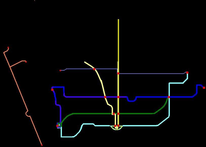
EDIT: Decided to add a Dundas Subway to my Fantasy Map: http://maps.google.com/maps/ms?ie=U...3.680784,-79.583588&spn=0.30788,0.837021&z=11

So instead of Bloor-Danforth going to MCC, I now have my new Dundas line going to MCC. The Dundas line basically, um, follows Dundas. From Yonge-Dundas to Hurontario-Dundas. And to the east somewhere. So the Bloor line will end at Kipling, and Dundas takes over. Only real issue with that is between Dundas West and Kipling, Dundas looks to be pretty close between Bloor and Eglinton, so for the time being, Dundas line could interline with Bloor between those two points until such time as building the Dundas subway in there would be needed. I like the idea of a subway stop at Yonge-Dundas, and I like the idea of a subway stop at Hurontario-Dundas. Makes sense to have a subway all along Dundas no? No? Well in my world yes!

2976716685_ee4707a6d2_o.gif


Doesn't look as pretty as just having a Dundas-Bloor-Danforth subway, but alas, it's all fantasy anyway. It also might be a mistake because it means no more one-seat ride from MCC to STC. Unless I steal the Danforth bit to make a Dundas-Danforth subway and leave the Bloor subway separate lol. But that doesn't really make sense either. Ah well.
 
I havent learned how to make a fantasy subway map, but ideally I would like to see one containing the following:

One that loops King and Queen, although I am not quite sure where it would loop on either end. I love the idea of being able to go up to the Bloor Danforth line on either end so I would someone implement that also.
 
Hey doady,

I still think you have the best fantasy transit map of anyone. All the other maps always seem to have elements that make me question that person's logic and knowledge of the GTA (such as plans that feature 3 lines serving Malvern and 3 lines serving Sherway, but Thorncliffe Park completely forgotten).

Sure, it's completely unrealistic in terms of the cost of implementing such a plan. And it's certainly not perfect (why are Malton residents the only people who get a direct train to Pearson?). But if some global catastrophe occurred tomorrow, forcing the government to invest $200 billion into transit all at once, I would point at your map and say "build THAT".

Thanks CDL. I actually originally intended the map to be realistic, but I guess it got out of hand somehow...

I have never really been happy with what I have proposed for the airport, but I like the real life proposals even less. Mississauga Transitway route(s), Eglinton Transit City, and Blue 22 all at the same time? Seems like overkill, and even so they still do nothing for Brampton or York Region. Perhaps the Eglinton subway really is the answer.
 
I updated my map with some changes to some lines and some numbers. Overall, it is still pretty much the same as before. You can it see it here.

That's fantastic, particularly if an integrated fare system is implemented with GO. It would seem like using the London Transport system.
 
Doady, that's a great map, I think you served the suburbs in a much more logical way than I did.

Three suggestions:

1) On the Jane subway, consider introducing a branch line south of Bloor - half the trains continue to Front, the other half run along either Queen, Dundas, or College.
2) I'm totally sold on express subways after going to New York. I'd like to see the Bay subway line offer express service, only stopping at Union, King, Dundas, Bloor, and Summerhill. It should also continue north, only stopping at St. Clair and Eglinton. Otherwise, scrap the Bay subway - it's redundant to have 19 subway stations between Yonge and University, all offering equivalent service.
3) Whether it be train or subway, it may be advantageous to have a direct transfer free transit line from downtown to Pearson.
 
Revised Map - Realist Perspective

Forced Fantasy or New Reality?


Click to Enlarge - I recoloured the GO lines because the current colours are ugly.
 
Last edited:

Back
Top