News   Jul 08, 2024
 278     1 
News   Jul 08, 2024
 375     0 
News   Jul 08, 2024
 815     0 

Transit Fantasy Maps

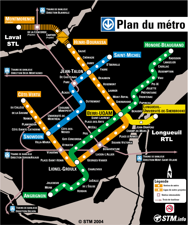
the present subway growth is in the wrong places...that old plan looks way better.

Present subway growth is in the right places...the problem is that the present plan is much smaller than it should be.

The city has grown substantially since that old plan was conceived.
 
This may be a little off topic, but as you all may know, the Region of Waterloo is currently conducting an environmental assessment for a light rapid transit line to connect the central transit corridor of the region. Being a longtime resident of the region, I've created a few maps for conceptual rapid transit networks.

The first map contains the LRT line currently under study including express bus routes which intersect this spine. It also contains inter-regional connections.
http://img244.imageshack.us/img244/8752/transitmapon4.png

The next is a subway-style map with a bunch of fantasy LRT lines.
http://img157.imageshack.us/img157/9800/transitmajigger64ip8.png

Here's a google map for reference.
http://maps.google.ca/maps/ms?ie=UT...77600247168599.000445ff9ce0e8935c806&t=k&z=11

Enjoy!
 
I saw the new subway map today, and thought I was going crazy. I acutally like the font, but there's something about it that makes it seem too text-heavy.
 
I guess the logic behind putting the actual municipal addresses of the stations on the new map would be that in this age of Google Earth and GPS devices, it "could" be argued more useful than where on Yonge, Danforth, Bloor, etc. the station roughly falls.

As an aside, I've always thought the lake should be shown on the south end of our subway maps to: 1.) remind people of its existence and 2.) to easily denote which way south is.

Here is one example, although I've seen better:

toronto-map.gif


Montreal shows hydrology too...

montreal_subway_map.gif


...as does London...

london-tube-map.jpg
 
Here's my idea of combining the Spadina extension with the Sheppard subway which may help construction costs (4 car train stations) and also prevent the YUS line from getting too long.
 

Attachments

  • SheppardSubway.jpg
    SheppardSubway.jpg
    86.4 KB · Views: 319
^ it's a good idea. I think it's been mentioned before in some form around here, but either way its good stuff.

It would definitely increase the use of the Sheppard line and provide an east-west link in the north end that is currently missing. It'd probably work well to alleviate some of the traffic on the Yonge line as well. I don't know if all of the stops on your Sheppard Line are necessary, but then again I'm not entirely familiar with the population density up there.
 
I love the old plan for the Toronto subway. The Queen, Eglinton, and other lines shown would be so wonderful to have now.

I also like the map you propose with hydrology. Unfortunately, the placement of the map on the current subways is so limited vertically.
 
Here's my idea of combining the Spadina extension with the Sheppard subway which may help construction costs (4 car train stations) and also prevent the YUS line from getting too long.

I like your map. Unfortunately, it makes too much sense. This is the TTC we're talking about.
 
Water does not belong on schematic maps of transit lines.

I think it has a place if it helps people understand where they are in cities where water plays an important dividing role.

The London Underground map needs to show the river so you can know which side of the Thames you are on. Same with Montreal.

Toronto, on the other hand, has no use for it as you're always going to be on the north side of the lake (exception = Islands).
 
I think it has a place if it helps people understand where they are in cities where water plays an important dividing role.

The London Underground map needs to show the river so you can know which side of the Thames you are on. Same with Montreal.

It might be okay if it is kept simple like on the London map, but the Montreal map is ridiculous. The rivers are more detailed than the transit lines themselves.
 
I thought the Subway ran later than 0130, and I thought the Sunday 1st train was much earlier than 0900
even here in Calgary the C-Train Mon-Fri is about 0410-0200
Sat 0510-0200
Sun 0530-0100
Stampede 24hr service (wish the buses were 24 hr too)
I had always thought the Subway ran much later, did it ever run later than the 0600-0130 M-S and the 0900-0130 on Sun? that seems wrong for a city of 3 million not to have a 24 hr system.
 
It might be okay if it is kept simple like on the London map, but the Montreal map is ridiculous. The rivers are more detailed than the transit lines themselves.

I will give you that one.
 

Back
Top