News   Mar 28, 2024
 466     0 
News   Mar 28, 2024
 313     0 
News   Mar 28, 2024
 329     0 

Transit Fantasy Maps

Does anyone know if their is a place I could find alternate TTC/ Go Maps? I think the one we have could be better and I think some services such as Up Express and Some Streetcars should be integrated. If not what software would you reccomend for creating such a map?

try playing around with this site from Neptis. You can customize maps to include what exists, what's u/c, planned, etc - all for the entire GTHA. You can also overlay some interesting stuff like land use. I only played around with it quickly, but IMO it does a better job than relying on individual system maps. Or dated Big Move visions bandied about by Mlinx.
 
try playing around with this site from Neptis. You can customize maps to include what exists, what's u/c, planned, etc - all for the entire GTHA. You can also overlay some interesting stuff like land use. I only played around with it quickly, but IMO it does a better job than relying on individual system maps. Or dated Big Move visions bandied about by Mlinx.

The maps are quite nice and detailed, however I also find them to be sluggish. Not sure if it's just my browser or other people notice the same thing.


Recently I produced my own transit maps, which I'm sure a few other people have done as well. I'd be interested to hear what you think.

1. TTC & GTA Rapid Transit, https://www.google.com/maps/d/edit?mid=zaK28KZzproA.kO19YMSpPS5I&usp=sharing

2. TTC Bus Network, https://www.google.com/maps/d/edit?mid=z_jWlQ3EOA2c.kMQg2VW_Z4co&usp=sharing

Looks good...my only comment is that for the Bolton line, my recollection is that the preferred routing was along the Barrie Line, then west parallel to CN main line just south of the 407, rejoining the corridor at Islington/407 and on to Bolton. I think their reasoning was that the Kitchener corridor would already be close to capacity (now even more so with RER). Even more of a problem now is that there isn't room/grade to get out of the Weston tunnel and onto that spur (without significantly widening the north end of the current tunnel). Barrie has more capacity for expansion of a new feeder line.

That and Beamsville is slated for a potential station for phase 2 of any Niagara extension.
 
Last edited:
try playing around with this site from Neptis. You can customize maps to include what exists, what's u/c, planned, etc - all for the entire GTHA. You can also overlay some interesting stuff like land use. I only played around with it quickly, but IMO it does a better job than relying on individual system maps. Or dated Big Move visions bandied about by Mlinx.
Handy tool - I tweeted it out via UT and credited you - I was surprised to see how comprehensive and up to date it was considering how fast-changing the plans are!
 
Looks good...my only comment is that for the Bolton line, my recollection is that the preferred routing was along the Barrie Line, then west parallel to CN main line just south of the 407, rejoining the corridor at Islington/407 and on to Bolton. I think their reasoning was that the Kitchener corridor would already be close to capacity (now even more so with RER). Even more of a problem now is that there isn't room/grade to get out of the Weston tunnel and onto that spur (without significantly widening the north end of the current tunnel). Barrie has more capacity for expansion of a new feeder line.

That and Beamsville is slated for a potential station for phase 2 of any Niagara extension.

I dislike that routing. I can't deny that the Kitchener corridor may be overloaded but the Northwest corner of Toronto is severely lacking in rapid transit. Something that a Bolton line could provide.
 
I dislike that routing. I can't deny that the Kitchener corridor may be overloaded but the Northwest corner of Toronto is severely lacking in rapid transit. Something that a Bolton line could provide.
I agree on that one. A 'Humberlea' station at Wilson and an Emery station at Finch (and the LRT) would probably be welcome. In either alignment, I think they were also suggesting a station at Islington and 407, linking to the transit busway.
 
The maps are quite nice and detailed, however I also find them to be sluggish. Not sure if it's just my browser or other people notice the same thing.


Recently I produced my own transit maps, which I'm sure a few other people have done as well. I'd be interested to hear what you think.

1. TTC & GTA Rapid Transit, https://www.google.com/maps/d/edit?mid=zaK28KZzproA.kO19YMSpPS5I&usp=sharing

2. TTC Bus Network, https://www.google.com/maps/d/edit?mid=z_jWlQ3EOA2c.kMQg2VW_Z4co&usp=sharing

Ah, well done. I still kinda like the Neptis one just because of the different land use overlays and whatnot. I didn't really have a sluggish issue. But had they gone with anything Google Earth-related, I'd avoid it like the plague. Something about GE always messes up on my comp. Google Maps I'm still okay with.

Handy tool - I tweeted it out via UT and credited you - I was surprised to see how comprehensive and up to date it was considering how fast-changing the plans are!

Thanks. I'm still a bit foreign to the Twitterverse (other than following the RoFo debacle a couple years back, and the Dellen Millard trial currently). But I def appreciate the shout-out.
 
SmartTrack 2.0

Convert the GO Stouffville line to Electric Multiple Units (EMU) with 3-4 minute headways. The route goes along the Lakeshore (4th track installed), then at Gerrard and Pape we go down the Relief Line (RL) tunnel, switching the RL to EMU technology as well. The crosstown under Queen Street becomes EMU avoiding all the Union Station issues. We meet up with the Union Pearson Express (UPX), which we then salvage by converting it to EMU and add a few more stations and serve north-west Toronto. A third track of the crosstown from Osgood Station goes up Pape, crosses a couple of bridges across the Don Valley and then up Don Mills Road.

The Sheppard LRT meets the Stouffville line.. The Steeles, Finch, Agincourt, Lawrence stations will significantly shorten bus routes in Scarborough. Most Scarborough bus routes will run east/west to feed the Stouffville line. As the east/west bus routes run faster than north/south routes transit times will be shortened.

The Stouffville line replaces the Scarborough Subway Extension (SSE) and alleviates the Yonge/Bloor crisis.
SMTK2.0.jpg


The idea is to get Metrolinx to work on a digestible project where they can gain experience with PTC train signaling and EMUs. It would be easy on Stouffville and UPX. Toronto needs both crosstown and relief line so it would be a good connector.
 

Attachments

  • SMTK2.0.jpg
    SMTK2.0.jpg
    778 KB · Views: 1,872
We were talking about using the Highway 401 corridor to expand the Sheppard Subway a few weeks ago. Any thoughts on this proposal from SUDA?

If you think Allen Rd + Spadina line was great city planning, if this is the kind of transit experience you think is acceptable, then you will support that proposal.

Screen shot 2016-04-28 at 4.16.56 PM.png
 

Attachments

  • Screen shot 2016-04-28 at 4.16.56 PM.png
    Screen shot 2016-04-28 at 4.16.56 PM.png
    1.1 MB · Views: 1,899
If you think Allen Rd + Spadina line was great city planning, if this is the kind of transit experience you think is acceptable, then you will support that proposal.

View attachment 74253

The proposal seeks to solve the issue of the lack of a high speed mode of travel across the north of the city. The only two feasible solutions to that are an underground subway or surface rail. Obviously the former is cost prohibitive given the probable low ridership of the corridor. Light rail isn't a good option since that's slower in speed and more local in nature.

So if we want to solve the problem of the lack of high speed travel mode across the top of the city, this seems like the only thing that would work.
 
IIRC, the plurality of trips on the network start and end in the suburbs, and the modal show of suburban to suburban travel is very low within Toronto (around 20%). The lack of a high speed link connecting our suburbs without detouring downtown is a problem worth trying to solve
 
We were talking about using the Highway 401 corridor to expand the Sheppard Subway a few weeks ago. Any thoughts on this proposal from SUDA?

elus0jO.png
I posted a modification of one of Wisla's maps 3 months back that took a similar view: combine the existing (Sheppard) with planned (DRL long, DRL west, Jane LRT tunne) to make a circle line.
toronto-2051-png.65767


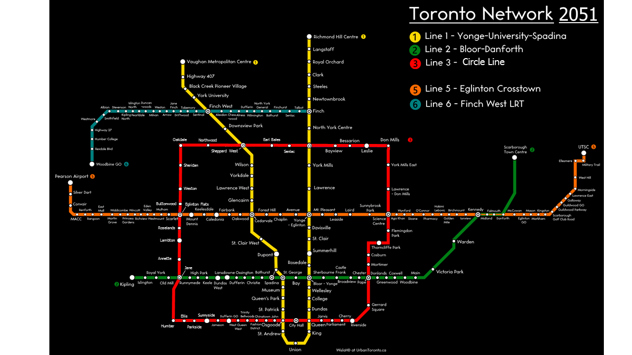
Go out another 20 years, and relief line goes up South Kingsway and Jane to Sheppard, Sheppard goes west to Jane, and ta-da! Toronto's own circle line.

Wisla, hope you don't mind I added on.
 

Back
Top