News   Mar 27, 2024
 1.2K     1 
News   Mar 27, 2024
 1.1K     2 
News   Mar 27, 2024
 639     0 

Transit Fantasy Maps

I don't doubt it will be costly. I do think it would still be cheaper than it's equivalent service (Yonge North Extension + DRL Long). Just what kind of ridership does a Richmond Hill line which has had a $10B investment into it achieve? $10B allows for a ton of flexibility; perhaps only $4B is needed to achieve maximum ridership potential.

I don't know if it's better or worse; I do think it's worth Metrolinx staff sitting down for a month and giving it a look.
Well, I think the 7.8 billion to get the Relief Line to Sheppard and Don Mills needs to happen to relieve Yonge subway line anyway.

So if this line cost a theoretical $10b then we are talking $2.2b more to get it to York Region from Sheppard. That is a good investment I think, when considering however much it would take to correct the RH-GO alignment and upgrade it to GO-RER.

Yeah, thing is, I really doubt $10b is necessary to give the Richmond Hill line 5 minute or better frequencies, on a shorter more direct route, with good connections at Eglinton/Sheppard/Yonge and bus terminals at York Mills, Steeles, St. Clair, Finch, etc.

It's a short line. There is no need to quad track to separate express/local service.
 
Below is my attempt to create a "realistic" fantasy transit map after making many, many less-than-realistic maps over the years. I've spent some time reading this forum and various transit agency documents that have lead me to create the map below.

TTC 2030 v1.0.jpg


Concepts and caveats;
  1. Downtown Relief Line & Core Connector [grey corridor]
    1. To relieve congestion on Yonge line and Bloor-Yonge station.
    2. To connect future core GO RER stations with existing core transit services.
    3. To relieve future track/passenger congestion at Union Station that may result from GO RER services improvements.
    4. Terminates at Don Mills station and Jane station - goal to improve connectivity with future Jane LRT and Viva bus services.
  2. GO Regional Express Rail [bold green corridors]
    1. Electrified in accordance with current Metrolinx plans - all Toronto corridors except Milton, Barrie, Richmond Hill bound.
    2. Electrified GO RER routes goal to have all day, two way, frequent service - at least one train every 10 minutes during rush hour.
    3. Connectivity with other transit modes - added stations to allow transferring with new and existing Subway, LRT and BRT services.
    4. Strategic capital investments to enable frequency and connectivity goals - incremental improvement over time such as station expansion, added rail lines, grade separation, etc.
    5. Creation of a series of new downtown core GO RER stations with the goal of improving use of GO service outside area surrounding Union station - primary transfer stations would include Lakeshore West, Queen & Dufferin, Corktown, and Queen East. All these stations are connected with the DRL [Grey line] which allows passengers in downtown core to access GO RER services without needing to access Union Station or congested Line 1.
  3. GO express diesel service [narrow green corridors]
    1. Similar service as exists today - limited to rail corridors that are not to be electrified; notably Milton, Richmond Hill, and Barrie corridors, as well furthest portions of Lakeshore West, Kitchener, and Stouffville corridors.
  4. Sheppard-Finch LRT [northern red corridor]
    1. Conversion of Sheppard Subway from heavy rail to light rail vehicles to allow surface travel in similar fashion to Eglinton Crosstown.
    2. Combines future Finch LRT and Sheppard East LRT into a single rail corridor.
    3. Connection between Finch and Sheppard portions is routed on map as a surface connection that travels on Bathurst. This allows some improved transit in higher density areas. Routes further east are served by the Line 1; routes further west are served by Line 1 and are lower density areas, especially around Downsview airport. I find 44North's concept of routing for a combined Finch-Sheppard LRT very enticing but I am concerned about the cost of added underground construction versus the potential benefits.
  5. Extension of Line 2 [blue corridor]
    1. Eastern extension into Scarborough Town Center as recently proposed; includes Lawrence East station to improved connectivity with future potential Lawrence East LRT or BRT. Lawrence East station could be planned as a future fill-in station.
    2. Western extension into downtown Mississauga; I envision this extension as elevated from Kipling to just east of Hurontario, and underground from Huronontario to Eglinton. I have some concern about this extension creating capacity issues on Line 2; my thought is that improved GO RER and the DRL will aid in reduced service demand on Line 2 which will enable the extension.
  6. LRT/Streetcar service [various red corridors]
    1. Boldest red lines are completely grade separated LRT services offering Subway-like service speed; notably, the central portion of the Eglinton LRT, Sheppard-Finch LRT, and Hurontario LRT.
    2. Medium-bold red lines are right-of-way corridors that will allow faster, more consistent service with lowers construction and operating costs compared to grade separated routes; notably, Sheppard East, Finch West, Eglinton East, Eglinton West, Waterfront, Spadina, St. Clair West, Jane North, Hurontario North.
    3. Narrow red lines are mixed traffic Light Rail where street widths do not allow for right-of-way corridors and estimated demand does not warrant grade separation.
  7. BRT routes in Mississauga and York Region [purple corridors]
    1. Marked approximately as described in documents that layout currently proposed and/or under constructed routes.
    2. Bolder lines are right-of-way routes and narrower lines are mixed traffic routes.
  8. Unmarked future service improvements under consideration.
    1. Extension of DRL to Richmond Hill; eliminates need for Richmond Hill GO route, may help to relieve additional congestion on Yonge line. Alternatively...
    2. Don Mills north BRT; improves connectivity with York Region bus transit.
    3. Lawrence West BRT or LRT; highly used, wide corridor.
    4. Steeles West BRT or LRT; highly used, wide corridor.
    5. Kipling BRT; to serve as an Etobicoke central north-south transit corridor.
 

Attachments

  • TTC 2030 v1.0.jpg
    TTC 2030 v1.0.jpg
    2.7 MB · Views: 2,138
Last edited:
Here's my alternative alignment for a Scarborough Subway. Past Sheppard, take it along the rail corridor to provide a connection to Malvern:

I545FRU.jpg


And here's my relief line extension. I don't think it should go to Richmond Hill; if it goes past Finch it should cross the DVP to Steeles & VP, or continue to Markham, to Highway 7 and VP or Warden:
JvLDjmn.jpg
 
Below is my attempt to create a "realistic" fantasy transit map after making many, many less-than-realistic maps over the years. I've spent some time reading this forum and various transit agency documents that have lead me to create the map below.

View attachment 69313

Concep
  1. Extension of Line 2 [blue corridor]
    1. Eastern extension into Scarborough Town Center as recently proposed; includes Lawrence East station to improved connectivity with future potential Lawrence East LRT or BRT. Lawrence East station could be planned as a future fill-in station.
    2. Western extension into downtown Mississauga; I envision this extension as elevated from Kipling to just east of Hurontario, and underground from Huronontario to Eglinton. I have some concern about this extension creating capacity issues on Line 2; my thought is that improved GO RER and the DRL will aid in reduced service demand on Line 2 which will enable the extension.
A Western extension of line two would surely serve Sherway Gardens.
 
Concepts and caveats;
  1. Downtown Relief Line & Core Connector [grey corridor]
    1. To relieve congestion on Yonge line and Bloor-Yonge station.
    2. To connect future core GO RER stations with existing core transit services.
    3. To relieve future track/passenger congestion at Union Station that may result from GO RER services improvements.
    4. Terminates at Don Mills station and Jane station - goal to improve connectivity with future Jane LRT and Viva bus services.
I think the Jane terminus is a good one. If the lower half of the Jane LRT is to be tunneled anyway, it might even make sense to push the subway up to Eglinton Flats and the Crosstown, with surface LRT north of there.

You could also have an interchange at Jane/St.Clair/Dundas. Call it Lambton, and you could have the Milton GO line (and midtown line if it ever happens) and a new terminus for St. Clair. If you wanted to be ambitious with streetcars, you could even push the Dundas line through the junction to terminate there as well.
 
This is a map I came up with:
Screenshot 2016-03-21 21.18.03 (2).png

*should say: Britannia LRT, Sheppard LRT
 

Attachments

  • Screenshot 2016-03-21 21.18.03 (2).png
    Screenshot 2016-03-21 21.18.03 (2).png
    968.5 KB · Views: 3,929
Last edited by a moderator:
Unionville Subway
This is a proposal to create a TTC Unionville subway line to replace the GO Stouffville line.
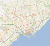
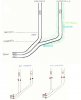
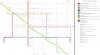
It would run at grade, from Unionville Station in Markham to Scarborough Station and then in a tunnel from Scarborough Station under the GO tracks to Pape and Gerrard to meet the Relief (subway) Line. The Relief line starts from the Pape Subway station to Pape and Gerrard and then southwest to Queen Street and west under Queen to University. There will be three tracks from Pape and Gerrard to Queen and University. The Unionville subway will have the dedicated southern track, the Relief line, the dedicated northern track and the middle track is shared by both. The dedicated tracks run inbound in the morning and outbound in the evening while the return trains run on the shared middle track.
03.jpg


The Unionville subway replaces both the GO Stouffville line and the Scarborough Subway Extension (SSE),
The Unionville to Scarborough stretch is economical because it is at grade. If there were room on the surface of Lakeshore line from Scarborough to Pape and Gerrard for a subway line, time and costs could be saved.
Eliminating the SSE is also a saving.

Markham loses a commuter train but the Unionville subway station can serve as a hub for a bus network.
The Sheppard LRT meets this line. The Steeles, Finch, Agincourt, Lawrence stations will significantly shorten bus routes in Scarborough. Most Scarborough bus routes will run east/west to feed the subway line. As the east/west bus routes run faster than north/south routes transit times will be shortened.

Deleting the SSE lightens the load at Yonge/Bloor.
Deleting the Stouffville line lightens the load at Union Station.


Everyone I've showed it to has a reason not to like this idea.
I'm ready for more.
 

Attachments

  • 03.jpg
    03.jpg
    57.1 KB · Views: 1,880
Interesting graphics. They literally look like one of those "back of the envelope" drawings that many Toronto transit plans originate from.
 
Here's a super amazing, completely unrealistic, probably unfeasible, probably ridiculously expensive Brampton Rapid Transit vision map.
Brampton Masterplan.jpg
 

Attachments

  • Brampton Masterplan.jpg
    Brampton Masterplan.jpg
    1.2 MB · Views: 1,739
Another streetcar network map, inspired in part by @DonValleyRainbow's recent post in the DRL discussion, particularly on serving the Portlands and rerouting some routes after the completion of the DRL. http://urbantoronto.ca/forum/threads/ttc-relief-line-proposal-drl.6155/page-432#post-1104118.

i2sFyBi.png


The plan here would be to upgrade the streetcar routes to LRT routes, either entirely or those that would make most sense. I included a few extra routes, as well as my own sense of how lines could be routed (so, for example, I split the Waterfront West LRT at Roncesvalles and LRT-ified the old 507 west of Queen/Roncesvalles), but the gist of this is to show the potential for heavily expanded downtown service relatively cheaply. Going from serving about 10,000 per hour per direction to 25,000 per hour per direction along all of these routes could drastically reduce overcrowding and improve running conditions for a wide swathe of the old city.

Ah never mind, figured it out. Here's the link to the Google Map in any case.

https://www.google.com/maps/d/edit?hl=en&hl=en&authuser=0&authuser=0&mid=zM7XQoNr2gLw.kqPqUuW2w3f4
 

Back
Top