News   Jan 03, 2025
 667     1 
News   Jan 03, 2025
 811     0 
News   Jan 03, 2025
 1.3K     0 

Transit Fantasy Maps

The are numerous ways to improve network connectivity, without spending billions on an extension that would be the least used in Toronto's history.

Connect the Finch West LRT to Sheppard-Yonge station, for example.

And no, ridership isn't the only criteria, which is why I'd be willing to stand behind a SheppRd Subway east extension, as long as it's on the surface. But the western expansion would be so little used that I can't reconcile spending that much money on it, especially when there are cheaper and equally effective options.

Isn't the main reason the Sheppard the least used is because it's only five kilometres long? It's like if the Yonge Line only ran from Bloor to Union. Extended to its originally intended length it'd definitely be competitive with other lines in terms of ridership. But I like your thoughts on merging the Sheppard subway with the intended extension of the Scarborough RT corridor into Malvern though.
 
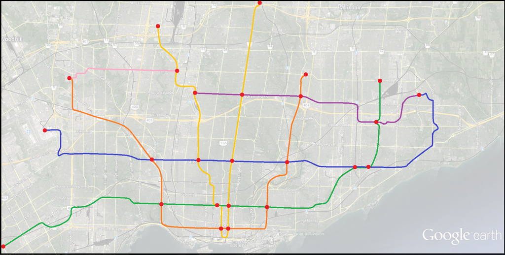
Okay, here's my latest foray into the world of cartography:


The main difference from other widely discussed plans on here is that I offer a new fix solution as to where to terminate the western leg of the DRL. Instead of doubling back to the airport, I have it head up Highway 27 on a elevated guideway pass Woodbine Racetrack and the Woodbine Centre to Humber College where it'd intercept the Finch West LRT, which itself is extended to Dufferin then follows the transit-only lanes to an underground connection at Sheppard West Stn across the platform from the Sheppard subway.

The Sheppard subway is extended both ways from Dufferin to Malvern Town Centre via the same alignment as the defunct Scarborough RT via Centennial College Progress Campus.

At Malvern Town Centre the Sheppard Line meets the Crosstown extended to MTC via Morningside, McLevin and Sewells. The Crosstown heads south from there via U of T Scarborough all the way across to Commerce Blvd then via its own Hwy 427 right of way to Carlingview/Dixon before terminating at Pearson Terminal One.

I also extend the Bloor-Danforth to McCowan-Finch in the east and to Hurontario-Dundas in the west where it intercepts a Hurontario LRT which traverses its whole length from Lake Ontario to the Caledon border (Mayfield). The DRL in the east extends to Seneca College Newham Campus at Finch and completely eliminates the need for surface transit its whole length from Finch/Don Mills to Roncesvalles/Queen with one kilometre or lesser apart spacing between stops.
 
For this reason, I like the suggestion of extending the Sheppard line to Downsview, and then interlining it with the Spadina extension to Vaughan.

Pay for a 4 km subway extension to Sheppard West.

Get a 18 km subway line to Vaughan and a 39km subway to Finch (via Union).

That's a lot better than Buy one get one free. Buy 4, get 48 free. Put another way, pay $1.5B for 48 km - that's $28M per km. Cheaper than any LRT.
 
Last edited:
@Hopkins123 TBH I would just extend FWLRT all the way to at least Finch and Don Mills on your map. And probably to McCowan-Finch.

@BurlOak Another thing that is often ignored, is that these subway routes, especially Line 1, are getting really really long. Long routes like that became operational and maintenance nightmares.
 
A long subway line may be a problem. If you think of the YUS as a continuous loop where as soon northbound train arrives at Finch, they have to move south to make room for the next train. One delay anywhere affects everything.

With an interlined Sheppard, the branches can be isolated. Trains can be held on Sheppard (or the ramp between Sheppard and Spadina) to ensure timing of the YUS south portion is optimized. Having Wilson yard right there also helps as train can (taken out of service or added as needed.
 
Pay for a 4 km subway extension to Sheppard West.
It's closer to 3 km - recall that they built tail tracks as far as the station box for Senlac would be. And if you wanted to cheap-out, you only need one new station (Bathurst) and add platforms at Downsview station.

That's going to be a fraction of the cost of the 8 km from Don Mills Station to Scarborough Centre - and another 5 stations or so (7 if you stick to the original plan). And it provides the connection into the yard at Wilson, that's going to be very useful for service on the Yonge line - especially if they extend north to Richmond Hill.
 
Isn't the main reason the Sheppard the least used is because it's only five kilometres long? It's like if the Yonge Line only ran from Bloor to Union. Extended to its originally intended length it'd definitely be competitive with other lines in terms of ridership. But I like your thoughts on merging the Sheppard subway with the intended extension of the Scarborough RT corridor into Malvern though.
The real mistake of Sheppard was to leave it entirely within the North York stretch of Sheppard East. It freed up buses that would've had to travel all the way to Yonge, that's about it. The stretch of Sheppard between Don Mills and Agincourt was probably denser than Yonge - Don Mills, and has far more longitudinal bus routes. That's where the line should've ended at.
 
It's closer to 3 km - recall that they built tail tracks as far as the station box for Senlac would be. And if you wanted to cheap-out, you only need one new station (Bathurst) and add platforms at Downsview station.


There may be tail tracks past Yonge, but the line needs to extend beyond Dufferin too.

Four ramps are needed

1) westbound to northbound track ramp would join into the Spadina line near future Downsview Park.
2) southbound to eastbound would leave Spadina line just east of future Downsview Park
3) northbound to eastbound would leave Spadina line just north of Wilson.
4) westbound to southbound would join Spadina north of Wilson.

I would guess that there would be about 3km of ramp type single track. Of course, the entire thing would be build cut-and-cover.
 
Here's my short-term fantasy map for the track configuration in the Kitchener GO corridor. I think that to support increased local service, we need a flyover onto the Pearson Spur, which would help re-organize the tracks by speed and direction.

Currently trains operate in any direction on any track, though generally UP operates on the southern pair of tracks while GO and VIA operate on the northern. This is seriously problematic if we are serious about increasing the frequency and number of stops for local service, because having trains of different speeds sharing the same track significantly reduces capacity and service reliability. To some extent the current setup is of a "fast line" for UP and a "slow line" for everyone else. But UP "express" trains are actually a fair bit slower than GO Express and VIA trains, and that to use the fast line, GO and VIA must cross UP traffic at Pearson Junction. Furthermore, having two pairs of railways means that trains cannot switch between the fast and slow lines without interfering with traffic going the opposite direction.

A further issue with having UP trains on the south side is that the Union UP station is on the northernmost track. UP trains therefore need to cross all other Weston corridor services to serve it.

So I propose a unified 4-track railway sorted by speed and direction, with fast trains on the outside and slow trains on the inside. Having local trains in the centre allows them to turn back without interfering with express trains travelling further. This arrangement means that westbound UP trains don't need to cross any other Weston Corridor services. Eastbound UP trains still do, but this can be partly assisted by the existing USRC flyunder.
Screen Shot 2016-02-13 at 18.37.56.png


Based on the way the Pearson Spur currently weaves under the 427 and over Goreway Dr., it would be impractical to build a direct flyover.
Screen Shot 2016-02-13 at 18.41.59.png


Instead, the Pearson tracks would rise up onto an elevated structure east of the 427 to cross over the Weston Sub tracks. (Shown at Carlingview)
Screen Shot 2016-02-13 at 18.41.46.png


Fortunately, this section of line has ample room, with the added bonus that there are no residential neighbours to complain about an elevated structure. (Shown at Highway 27)
Screen Shot 2016-02-13 at 18.41.26.png


This configuration would involve the loss of the existing dedicated freight tracks, but I figure that we'd gain more than enough capacity to offset this.
 

Attachments

  • Screen Shot 2016-02-13 at 18.41.59.png
    Screen Shot 2016-02-13 at 18.41.59.png
    338.4 KB · Views: 1,362
  • Screen Shot 2016-02-13 at 18.41.46.png
    Screen Shot 2016-02-13 at 18.41.46.png
    480.8 KB · Views: 1,328
  • Screen Shot 2016-02-13 at 18.41.26.png
    Screen Shot 2016-02-13 at 18.41.26.png
    482.4 KB · Views: 1,368
  • Screen Shot 2016-02-13 at 18.37.56.png
    Screen Shot 2016-02-13 at 18.37.56.png
    134.3 KB · Views: 1,504
Last edited:
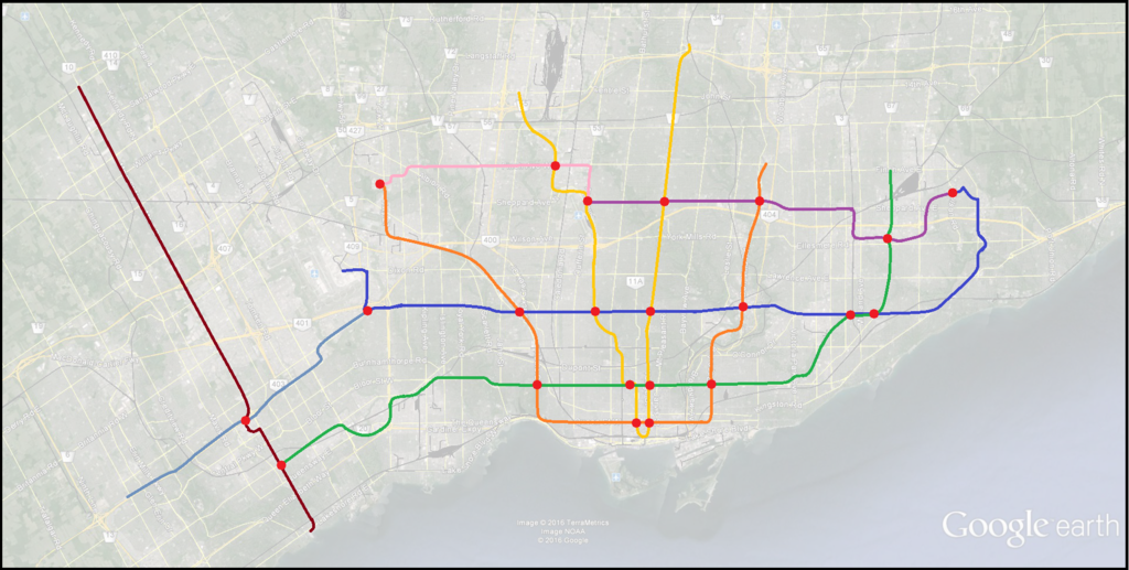
My bad, I posted the wrong map. This one better fits the description I outlined in my previous post:


The Toronto transit map will one day have to resemble something like this [Berlin], where everything is placed on one map. (Go rer/upx/smartrack/lrt/subway).

I've heard arguments before that the TTC and other gta systems should just be absorbed into Metrolinx to make for consistent branding.

IMG_20151010_083552.jpg
 

Attachments

  • IMG_20151010_083552.jpg
    IMG_20151010_083552.jpg
    2.4 MB · Views: 1,497
There may be tail tracks past Yonge, but the line needs to extend beyond Dufferin too.

Four ramps are needed

1) westbound to northbound track ramp would join into the Spadina line near future Downsview Park.
2) southbound to eastbound would leave Spadina line just east of future Downsview Park
3) northbound to eastbound would leave Spadina line just north of Wilson.
4) westbound to southbound would join Spadina north of Wilson.

I would guess that there would be about 3km of ramp type single track. Of course, the entire thing would be build cut-and-cover.
I'm not sure why you'd have any ramps to the Spadina line. I'd think you' just run it under (or perhaps over if there's clearance) the existing platform, and then curve it down into the yard. I'd assume there's some old plans somewhere.
 
To interline north and south, I think several tracks are required. This results in only one conflict point, and train frequency is half as much at that point. (I recall checking, and Sheppard line had to go under the Spadina line - not enough clearance above).

SW.jpg
 

Attachments

  • SW.jpg
    SW.jpg
    510 KB · Views: 1,479
Here's my short-term fantasy map for the track configuration in the Kitchener GO corridor. I think that to support increased local service, we need a flyover onto the Pearson Spur, which would help re-organize the tracks by speed and direction.

Very well thought-out this. I quite like the vision for 2030, the practicality of keeping express and local service segregated, and dubbing local SmartTrack-type service as "Suburban". If high-floor EMUs compatible with existing UP Express platforms are selected for Suburban service, placing the local platforms in the middle of the corridor ensures that only one high-floor platform (with elevator and stairwells) will need to be built at each suburban station.

According to GO's page for the Kitchener RER, it was my understanding that trains originating in Kitchener would run express (no stops) from Bramalea to Union. While I can see network connectivity value to adding a stop to express service at Bloor/Dundas West for network connectivity, I wonder about it's compatibility with regional services on the same corridor.

I'm a bit confused about the nature of what you have labelled as GO Shuttle. Is that just a connection running between the Pearson Junction and Pearson Airport on the spur? If so, why not just have all UP Express trains stop at the Junction and then run express to Union from there?

It also appears that from your 2022 map that half of the 4 Suburban trains per hour are routed to Pearson and the other half are routed to Bramalea. Personally, I think there is more value in maintaining 15 minute frequencies on the RER route to Bramalea in order to connect better with GO's 407 routes and train-bus services.

Based on the maps, I'm guessing that your Pearson Junction station is somewhere in the vicinity of Highway 27. Also, as a general concept I can imagine that stations would be added or relocated based on the outcome of the Metrolinx New Station Analysis.

As an aside, I know it's not possible with the current track layout, but do you think would it be feasible for Milton trains to also stop at Dundas West?
 
Last edited:

Back
Top