News   Jul 09, 2024
 385     1 
News   Jul 09, 2024
 1.2K     2 
News   Jul 09, 2024
 501     0 

Transit Fantasy Maps

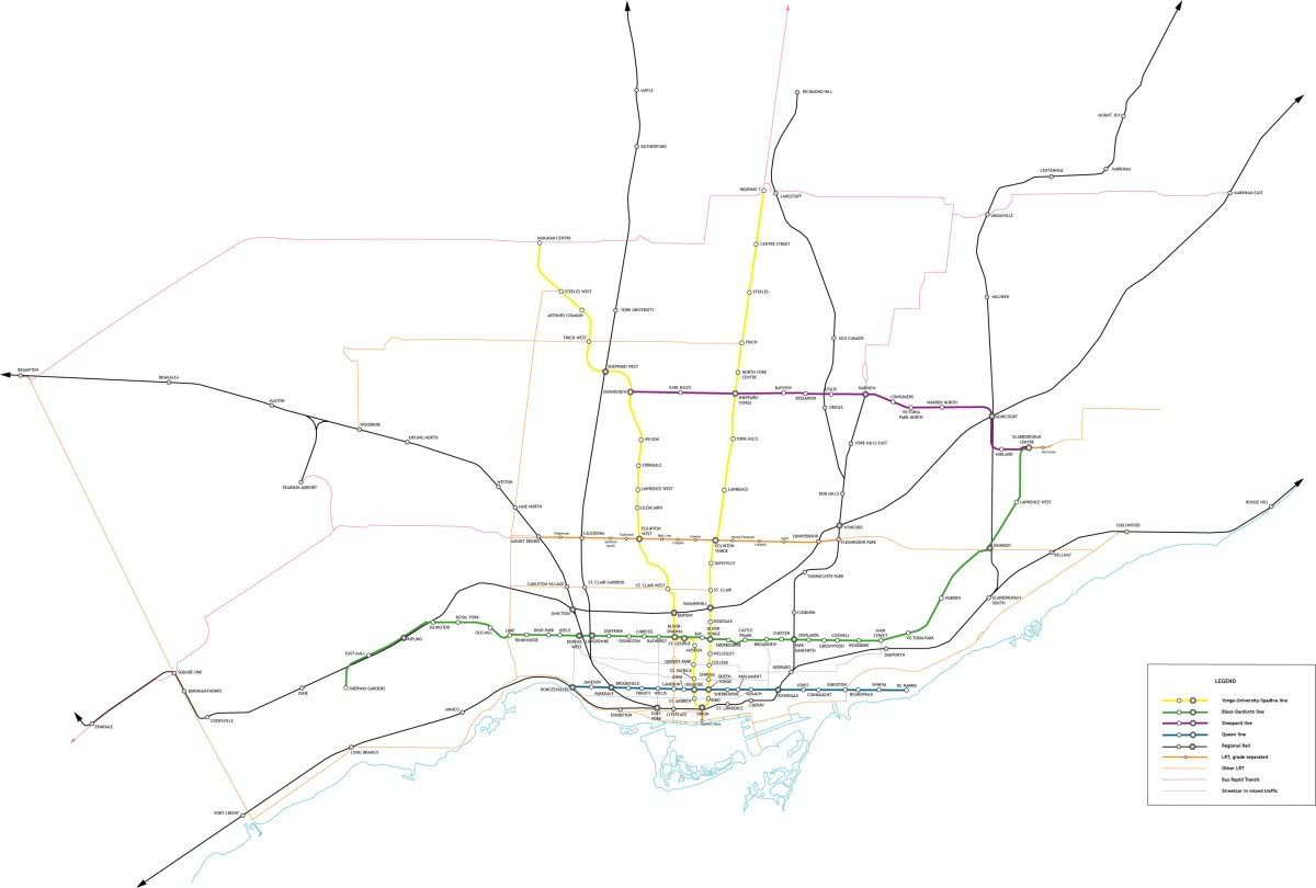
Gorgeous map, without question. However, it's distressingly typical of the parochial thinking in Toronto. Borders set in the 1800s and lines drawn in the 1950s are sacrosanct. There's no acknowledgment of the real dimensions of "Toronto"; no wider vision. Two or three stops in Richmond Hill and a handful of soft, mushy arrows of blue postulation are the only timid bows to the realities of a city already verging on six million. This is imaginary! This is can be anything you want! You don't have to hem it in with the TTC's current mandate; in fact, it's thinking like that that will doom it to be a self-fulfilling prophecy. Why are you content to confine the boundless future to the limited boxes of generations past?

Here Here.

To limit the vision to the borders of the city of Toronto is to seal the fate of the region in congestion and sprawl. No matter how much we can improve the situation within Toronto, a shining beacon surrounded by disaster is still mostly disaster.
 
I agree, these are great fantasy maps. And I may piggy back on them and post my own, so accept imitation as the greatest form of flattery. But the spacing/scale issue is my only complaint.
 
My goal wasn't to create a map to scale or geographic accuracy... it was to create a map that was able to show all the detail of the lines that will be built by 2020 in the central GTA under MoveOntario and Transit City, and a map that is to scale would be impossible to produce without being ridiculously large. I borrowed ideas heavily from the London Underground map, which discards geographic scale for the same reason. The central area is disproportionately larger because of the intricacy of the lines and the sheer number of them, while suburban areas are disproportionately small. If I had followed geographic scale, the GO line out to Barrie would be a single station far above any other part of the map and Cambridge and Hamilton would be far to the left. I could easily create a geographically scaled map, but that would be too easy. The purpose of this map is simply to diagramatically show all the stations and lines in a fairly logical and and simple way.
 
it was to create a map that was able to show all the detail of the lines that will be built by 2020 in the central GTA under MoveOntario and Transit City

Wow, how can anyone look and that map and still doubt Transit City is the superior option to a few paisley extensions to the Sheppard Line? Virtually no corner of the city would be left untouched by rapid transit if and when its completed. If we were to wait for subways to accomplish this, the city would be so backwards by then there'd be no need for rapid transit at all.

I especially like the Eglinton-Crosstown line and am glad that you recognized Scarborough-Malvern as an important extension of it. If it became a full-flegded subway; along with the other proposals in MoveOntario, we'd never have to worry about transit in Toronto ever again!
 
Wow, how can anyone look and that map and still doubt Transit City is the superior option to a few paisley extensions to the Sheppard Line? Virtually no corner of the city would be left untouched by rapid transit if and when its completed.

There are no rapid transit lines in Transit City because an on-street LRT is not rapid transit. The Sheppard Subway is real rapid transit because it is completely separate from vehicular traffic.

And of course that map makes Transit City look like a good plan because it uses the same symbolization for LRT and subway lines.
 
Wow, how can anyone look and that map and still doubt Transit City is the superior option to a few paisley extensions to the Sheppard Line?

Pretty easily.

For me, all it took was letting my eye wander along the Sheppard corridor ... east to where the subway abruptly stops and the LRT starts. And still eastward where SCC is but a stop to which no subways go, and all the major transfer points elsewhere. Then all the way back to Yonge, where the Sheppard line stops, and a Finch line starts all over again.

Although it did lead me to muse about a cross-Sheppard subway line that double-tracked the Yonge line between Sheppard and Finch...

(The map itself is beautiful. Including the detail with which it renders Transfer City.)
 
Not to start a subway vs. Transit City debate, but this is probably what would be built for the same cost if we went exclusively subway, assuming that the Danforth extension would be $2-billion, the Sheppard extension being $2-billion, and Eglinton West being $2-billion. Highballing the costs a bit, so feel free to imaginatively extend each line by a station or two.


RMsubway.pdf (425KB) (even the file is larger for some reason!! ;))


for comparison
TorontoRMalt2.png
 
Regarding the subway argument:

Can we seriously have one thread about Transit City that doesn't devolve into "DURR SUBWAYS ARE BETTER" vs "DURR LRT IS BETTER". This argument has been played out a thousand times before. The pro-subway people will never convince the pro-LRT people to come to their side, and vice versa. Stuff like this has ruined almost every other thread with any mention of TC because someone feels the need to mention how much better a network of LRT is compared to Sheppard, or how stupid TC is because it leaves Sheppard unfinished.

I hate to sound like a backseat moderator, but take it somewhere else. This thread is about maps, not whether or not extending the Sheppard Line is a good idea.

To the OP, that is a seriously awesome map, and I would not be surprised if it's better than whatever official one they come up with.
 
I'll be the first to post my own map. Here's one I did about a year ago and made some changes to recently.

TTCmap7resize.jpg


Full size here (pdf, 9.45 MB). The biggest change is converting the whole GO system to regional rail, with varying frequencies depending on the line. Where all the lines converge near downtown the corridor would have subway frequencies and act as a downtown relief line.

Edited to include pdf map.
 

Back
Top