News   Apr 19, 2024
 265     0 
News   Apr 19, 2024
 534     2 
News   Apr 19, 2024
 899     3 

Transit Fantasy Maps

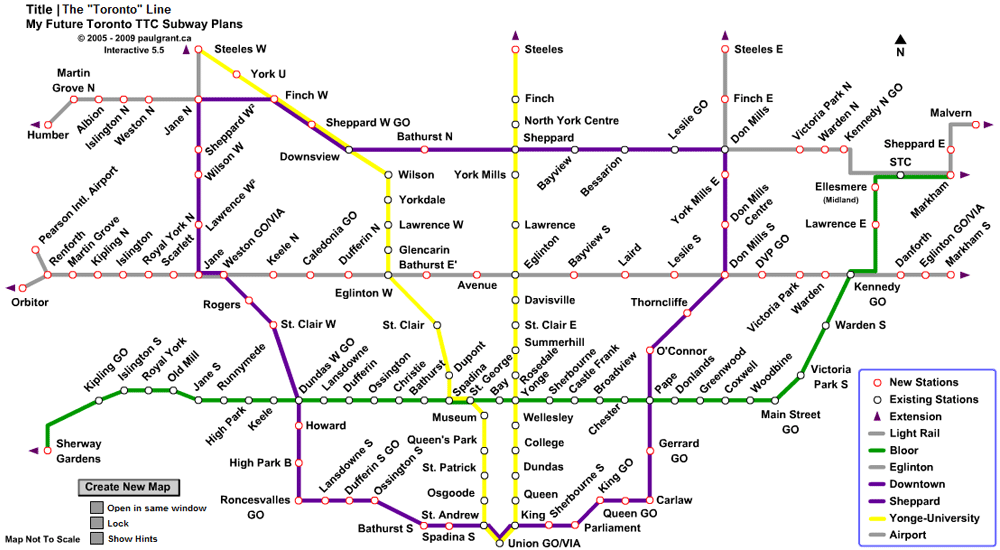
Ok, I agree with some of these deliberations. Let me retort, prominence was perhaps the wrong word. It should be made obvious, of course, the distinctions in service, but I don't think, for instance, the GO lines should be made any harder to see, or appear insignificant because of a grayed-out representation. There was a similar issue concerning the map earlier where the proposed Transit City LRT lines looked the same as the sub-way lines did. In correction, a sort-of hollowed-out effect was applied, and this did effectively communicate the hierarchy. A suggestion, therefore, might be to maintain the existing styling of a dashed-hollowed-out line, but again using regular colours instead of gray.
 
Does anybody here know of a program called spoorstrip.exe? It's used to draw route maps like the ones shown on wikipedia. Anyone know where I can get a copy of it? I tried emailing the developer but no response.
 
Nice maps.

299, I recognize and appreciate the London-esque treatment. I am wondering, though, why you chose not to jog the University line to the west (north of Downsview)? Doing so would not only be accurate, but would also afford the opportunity to more accurately render the Jane line, would it not?
 
My_TTC_Subway_Plans_Toronto_Line.gif


Here's one configuration of this map I made in Flash
 
I also find it strange how all these fantasy maps have lines that go no further than Steeles or Etobicoke Creek - there are a few logical cross-boundary routes, particularly the Yonge North extension.

The distance from Malvern to the Pickering Lands is quite a leap - if it is ever built (God forbid), there's a perfectly good rail corridor that leads almost right into where the terminal will go. With some track upgrades, a regional, limited stop public transport train to Union or Summerhill would be a piece of cake. And a stop in Malvern at Morningside and/or Neilson would give instant rapid transit connections without a subway or SRT.

You should be pleased with the one I'm working on. It covers EVERYTHING. I go as far north as Orillia, as far south as Fort Erie, as far east as Montreal and as far west as Windsor.

However I've run into some technical problems with flash (flash doesn't offer a pallet large enough to show everything I want to show, and scaling down will open a whole other can of problems), so I have no idea when it will be done.

Consider this a teaser.:cool:
 
Oooh! I want an Amtrak California-type operation for Southern Ontario - a provincial/VIA partnership to cover mid-distance travel to places like Niagara (even Buffalo with airport-style border services in a downtown Buffalo station), Brantford/London, Guelph/Kitchener, Peterborough, Cobourg/Belleville/Kingston.
 
Oooh! I want an Amtrak California-type operation for Southern Ontario - a provincial/VIA partnership to cover mid-distance travel to places like Niagara (even Buffalo with airport-style border services in a downtown Buffalo station), Brantford/London, Guelph/Kitchener, Peterborough, Cobourg/Belleville/Kingston.

You and I think alike.

I showed a preview to Tuscani01, and he liked what he saw. It was a 2880 x 2880 pixel image and it only showed the 416. That should give you an idea of how large this map will be.

I must add that this map is not affiliated with Metrolinx in anyway way. It predates my connection with the agency.
 
I also find it strange how all these fantasy maps have lines that go no further than Steeles or Etobicoke Creek - there are a few logical cross-boundary routes, particularly the Yonge North extension.

Forever stretching, meandering subway lines benefit who exactly? By the time a train arrives in the actual metro area there's no seats because everyone from Highway 7's already occupied them. Hence a subway's forced to overwork it's function, when LRT/BRT is more practical for outlining suburban areas.There are plenty of major gaps within the 416 infrastructure that have yet to be addressed, lets concentrate on that before we outright endorse commuter train-type service being done by subways.
 

Back
Top