News   Apr 17, 2024
 805     0 
News   Apr 17, 2024
 314     0 
News   Apr 17, 2024
 1.9K     1 

Transit Fantasy Maps

$50 billion for a DRL and some LRT? I can only assume the station will be solid gold and the track silver. Every other city on the planet would get 150km of subway for that price.

ST may have been written on the back of a napkin but at least it made sense. ST is a good idea because it makes use of Toronto`s current huge rail network.
5 LRTs for $3B each and 3 parts of the Relief Line at $10B each. Seems correct to me.
 
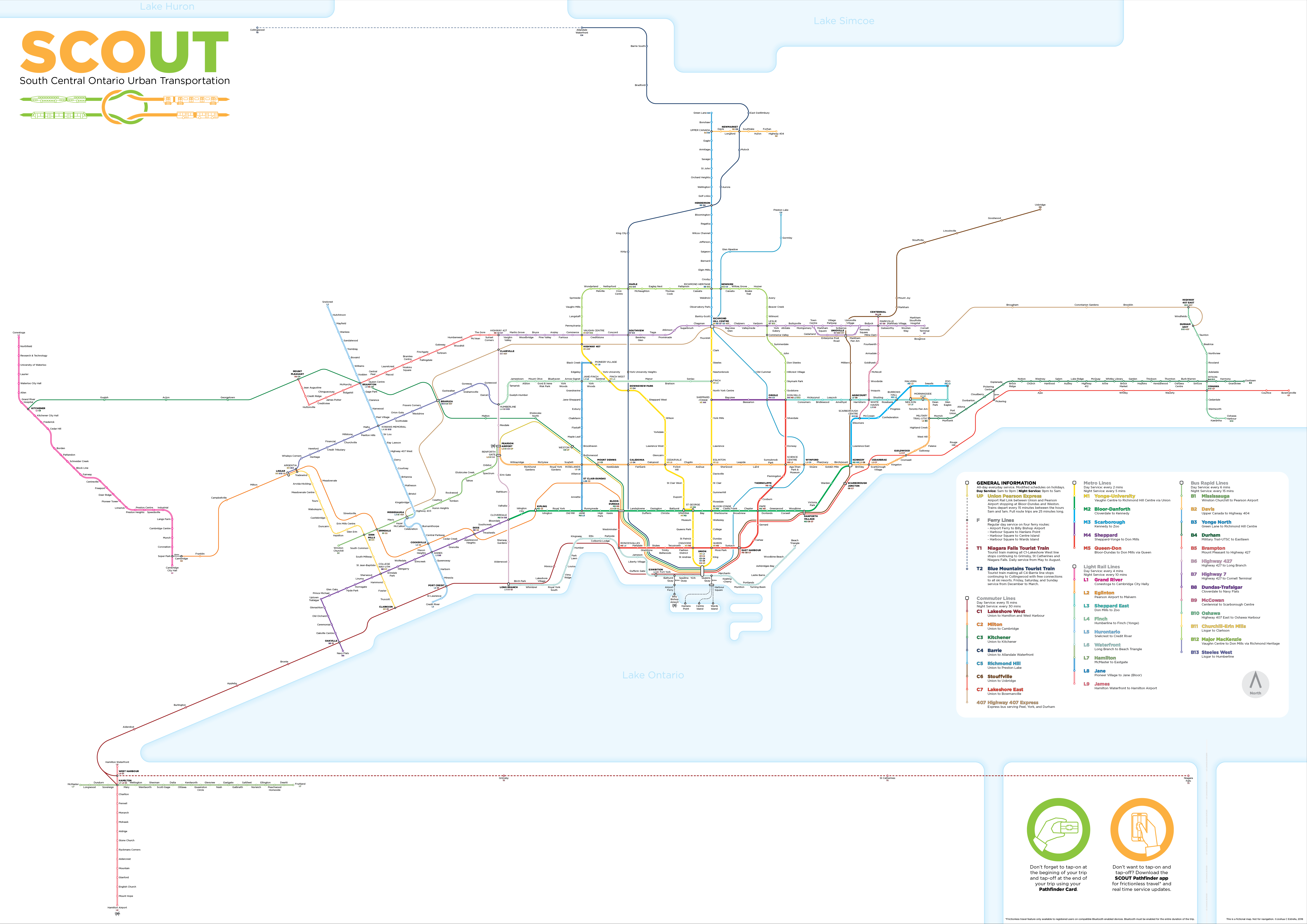
SCOUT-Map-Original.png

Posted this in a Facebook group and they suggested to post it here too.
 
SCOUT-Map-Original.png

Posted this in a Facebook group and they suggested to post it here too.

A decent map, but a complete absence of GO-RER, or other systems like the Bolton Line, Seaton Line, Crosstown GO, etc etc.

Clearly made by an LRT/BRT/Subway lover with a misunderstanding of rapid express rail.

Considering this is supposed to be a map for South Central Ontario, thats really unfortunate.

I'd suggest this individual go live in a city like London or Paris for a year and see how urban electrified rail is vital to a regions transit system.

That's a little ridiculous, I'm seeing all the current RER lines perfectly, and given that there are pretty much no subway extensions in that map except for RL and YN. The proposed LRT and BRT lines are little more than what Metrolinx is already eying or working on. Bolton, Seaton, and Midtown all came out to be either not cost effective or impossible given the current freight arrangements. It doesn't seem like a fantasy map, more of a future map (with most planned lines: it should be noted that Bloor West was not in any Metrolinx plans, while the SSE and Sheppard West were both mentioned in the 2041 Metrolinx Draft Plan).
 
That's a little ridiculous, I'm seeing all the current RER lines perfectly, and given that there are pretty much no subway extensions in that map except for RL and YN. The proposed LRT and BRT lines are little more than what Metrolinx is already eying or working on. Bolton, Seaton, and Midtown all came out to be either not cost effective or impossible given the current freight arrangements. It doesn't seem like a fantasy map, more of a future map (with most planned lines: it should be noted that Bloor West was not in any Metrolinx plans, while the SSE and Sheppard West were both mentioned in the 2041 Metrolinx Draft Plan).

Ok where is Liberty Village, Gerrard, St.Clair, Finch, Spadina RER stations on the map then mr smarty pants?

Theyve been replaced with a western DRL, something that is currently not on the books.

The DRL is a subway.
 
Ok where is Liberty Village, Gerrard, St.Clair, Finch, Spadina RER stations on the map then mr smarty pants?

Theyve been replaced with a western DRL, something that is currently not on the books.

The DRL is a subway.
Just because a few stations are missing doesn’t make it a bad fantasy map. Yes they are already in planning/funded and are important, but that doesn’t mean omitting them prevents the map from being valid.
 
Just because a few stations are missing doesn’t make it a bad fantasy map. Yes they are already in planning/funded and are important, but that doesn’t mean omitting them prevents the map from being valid.

I never said it was a bad map. You are projecting. I literally said it was a decent map!

I simply pointed out some flaws. Its not perfect. Chill. Not everything is an A+ or a failing grade.

For a fantasy map of a south central ontario transit system, its over relying on BRT and LRT and under relying on rapid express rail transit, which is the backbone of any regional system.

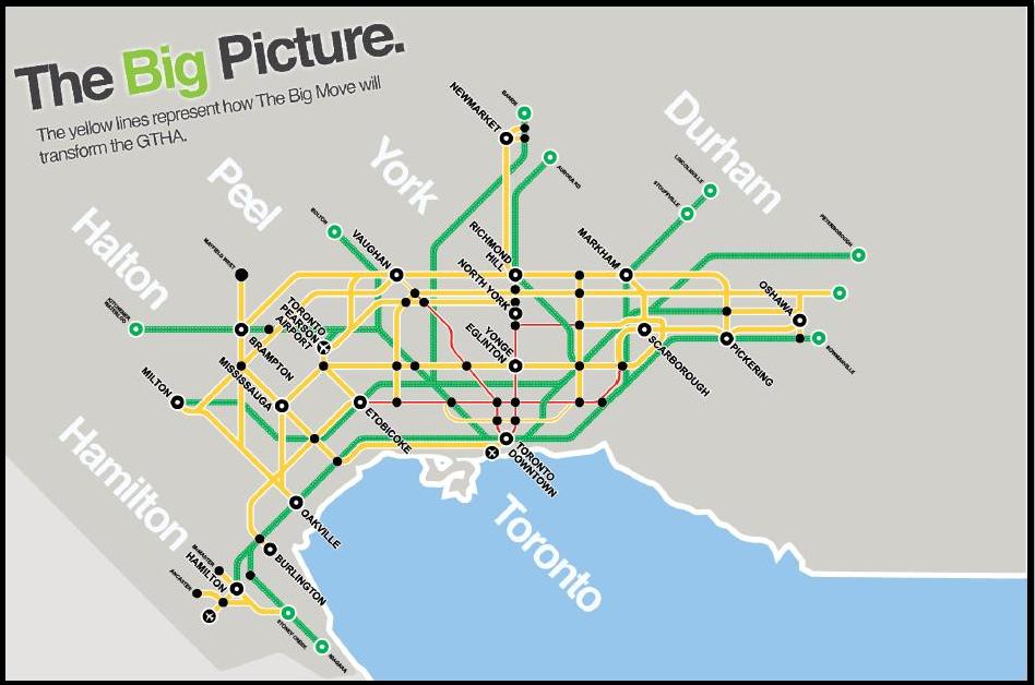
Personally, id add all the proposed RER stations, they arent even a fantasy they are planned, and the additional GO train lines that were proposed in the past, like in the Big Move plan

bigpicture.jpg
 
Last edited:
Honestly, this was more of a design exercise for me than a planning exercise.

In regards to the RER: if GO can turn what it currently has into 'turn up and go service' then I would be satisfied calling it RER.

Liberty Village and Spadina stations make sense as RER stations. I feel like a Gerrard station (at Gerrard and Carlaw, correct me if I'm wrong) wouldn't be helpful seeing as its inclusion basically duplicates the relief line skipping only one station between it and East Harbour. St Clair could be an RER station with connections to whatever they build on Jane and hopeful extension of the streetcar. I ride the Stouffville line and adding Finch, Lawrence East, or some other stop on its route doesn't 'feel' like an RER to me rather an attempt to turn it into a 'subway/metro'. Adding them reduces the distances between stops and takes out the 'commuter' in the 'hybrid commuter-rapid transit' part of RER. For the Stouffville line, I would only be comfortable adding East Harbor station. That way its 'rapid transit' at Union and East Harbour, then commuter to Unionville, and rapid transit again between Unionville and Mount Joy. The way I envisioned RER is 0.8 - 2 km Rapid Transit spacing and 4-6 km commuter spacing.

If I were to classify this map it would be a future/plan map rather than fantasy. The most fantastical parts of the map, to be honest, are the station names I gave (not really) and the McCowan line. The 'over-relying' on BRT/LRT is both a reflection of the current plan and a desire to still be realistic (subways are way too expensive for anything outside of Toronto proper). I'd rather not be the crazy guy suggesting a subway on Major MacKenzie (we have an election candidate in York Region actually proposing it). While I haven't 'lived' in London or Paris for an extended period I have visited and taken their transportation systems. An ideal/fantasy situation for me would be LRT's on every arterial (the 2km blocks in Toronto and York regions, some mile based grid in the rest of the GTHA) with 1km stop spacing complimented by a GO/RER that only stops in the 'cores' of each municipality (ie. Union to Scarborough Centre to Downtown Markham to Stoufville).
 
Re: Yonge Express subway

Despite everything being done, I'm starting to think that an additional line up near Yonge is the only solution. Perhaps a quasi-express with less stations.

I've suggested before running a completely new line up Bay Street from Queens Quay with stations at Union, King, Queen, Dundas, College, Bloor, St. Clair, Eglinton. From Davenport to near Davisville they can actually run under Yonge, because Line 1 is further east. From Davisville you can run under Duplex. If you want to have some fun, you can swap the lines at Davisville with a Lionel-Groulx-like station, so the new line, takes over the "express" line under Yonge up to Richmond Hill, and the original line runs under Duplex further north.

Surely such a line would be infinitely cheaper (and have a lot less closures) than trying to double-track the current line! Ultimately something is going to be necessary if subway ridership continues to grow.

Believe it or not, just 4 days before this post I began sketching a map of Yonge Express subway with two same key elements: using Bay, and an swapping the lines at Davisville. Here is what I got:

https://imgur.com/a/i6dRSox

The southern terminus of the new express line is next to the new City Hall, under Bay just north of Queen. Two other stations in CBD are Dundas and College, in order to spread out the riders. Hopefully, those 3 stations don't need to be very deep.

It is tempting to extend the line further south, with a terminus at King, Wellington, or even south of Union. However, then we need to deal with the PATH tunnels and with the Queen Street's Relief Line.

The Bloor station of the new line will have to be deep, in order to get under Lower Bay. Thus, no stations between College and Bloor.

From Bloor, it runs express to Davisville. No station at St Clair, and that should help select the optimal underground route to reach Davisville.

Davisville becomes a major interchange between the "old" Line 1 and the new express subway. Being on surface, that station should be relatively easily expandable. Some space can be taken from the yard.

North of Davisville, the new line takes over the existing Yonge tunnel and runs to Steeles and RHC. The "old" Line 1 needs a separate tunnel that connects to Eglinton LRT, in order to evenly spread the workload between the two Yonge lines. It should be possible to build a new 1-km long tunnel under Duplex.
 
Last edited:
Re: Yonge Express subway
It is tempting to extend the line further south, with a terminus at King, Wellington, or even south of Union. However, then we need to deal with the PATH tunnels and with the Queen Street's Relief Line.
What is the depth of a typical PATH tunnel - I would think 5m tops?
How many subways has Toronto or planned in the past 25 years that have had tunnels shallower than this - I would think 0.?

Somehow I don't think PATH is that important, and closing it for a couple of years is not that much pain for long term gain.

I thought maybe the Waterfront LRT's could continue up Bay Street and serve a similar purpose to this line. The use on this line would be similar both northbound and southbound.
 
Last edited:

Back
Top