News   Nov 22, 2024
 650     1 
News   Nov 22, 2024
 1.1K     5 
News   Nov 22, 2024
 3.1K     8 

Transit Fantasy Maps

After reading through most if not all of the threads for various HRT and LRT extensions, I've picked up the habit of designing fantasy lines and extensions in my free time.

Here I drew out a westward extension of the Relief Line down Queen into southern Etobicoke, while a Dufferin-Caledonia LRT connects the line to Bloor east of Spadina. This route would then ride along the Gardiner Expressway (or outright replace it) from Strachan to Jarvis, with potential extension to Cherry Street or across the Don River. It would also connect to both Line 5 and the Barrie GO at Caledonia.

dufferin-queen.png
 
After reading through most if not all of the threads for various HRT and LRT extensions, I've picked up the habit of designing fantasy lines and extensions in my free time.

Here I drew out a westward extension of the Relief Line down Queen into southern Etobicoke, while a Dufferin-Caledonia LRT connects the line to Bloor east of Spadina. This route would then ride along the Gardiner Expressway (or outright replace it) from Strachan to Jarvis, with potential extension to Cherry Street or across the Don River. It would also connect to both Line 5 and the Barrie GO at Caledonia.

View attachment 168520
It is a good alignment, however I envision that line more as a subway than LRT since it will likely need to be tunnelled along Dufferin and other places.

If the line terminated at Caledonia Station on Line 5, then that would be perfectly fine. However, I do question where north of Eglinton it could go. I suppose it could veer west to Keele up to Downsview and turn west and interline with the Sheppard Subway. It would have to build up a lot of ridership through development activity along Keele. (Keele and Wilson area looks especially ripe for development)

While following the Gardiner makes a lot of sense, I wonder if maybe between Exhibition and Fort York stations, it could dip south to Lake Shore, to support future opportunities at Ontario Place.

Overall, I like this line a whole lot, because: A) I think Relief Line should go to South Etobicoke, that is where future growth potential resides; B) Dufferin needs an upgrade from surface transit at least all the way to Dupont; C) It addresses the transit needs of the waterfront east and west, which appears to be basically forgotten by the powers in place.
 
While following the Gardiner makes a lot of sense, I wonder if maybe between Exhibition and Fort York stations, it could dip south to Lake Shore, to support future opportunities at Ontario Place.

If the Exhibition station is kept (to connect to GO) and Fort York, I'm skeptical about whether a station at Strachan/Lake Shore would provide enough benefits to justify the cost. I would instead reroute the Spadina streetcar line to stop there, with a transfer at Fort York. Especially if this line is a full-on subway line.

I chose to terminate it at Caledonia because of the low density north of St. Clair, let alone in North York. I also didn't want to have it compete with a line on Jane. But if it is extended northwards, I can see it being routed through Downsview Airport to encourage transit-oriented development there, and then continuing into Line 4.
 
mississauga central.png


Putting in something else I did recently - a west-east Mississauga LRT! It would mainly serve the purpose of opening more of downtown Mississauga to urban development, while also potentially relieving pressure on the Milton GO line.

Branch One - Eglinton
I think this is the most important branch; if Dundas is getting higher-order transit then Eglinton can cover more area than Burnhamthorpe can. Its western terminus is at Erin Mills Town Centre, at an intersection covered in pavement and low-lying buildings. Between Erin Mills and Hurontario is not very dense, however it does serve some areas of "gentle density", like townhomes. After crossing the 403 it passes through a mainly industrial area, including multiple headquarters of large corporations (BlackBerry, Sobey's, Bell, etc.) before following the Mississauga Transitway to Renforth Terminal. I would also have it continue north on Renforth and Silver Dart to Pearson, with Line 5 either terminating at or interlining with this line.

Branch Two - Burnhamthorpe
This branch would follow Dixie Road south from Eglinton to Burnhamthorpe Road, past Square One to Erindale GO. From there I would prefer it connect back up to reach Erin Mills Town Centre again, but I couldn't figure out a good route for the line to take.

I am personally of the belief that the cities immediately to Toronto's west and north should be planned like cities in their own right and not simply Toronto's sprawl, which means more than just buses and Toronto-bound rapid transit.
 
Here's the eastern/Scarborough portion of my fantasy map.

Features:

DRL up Don Mills to Steeles & Woodbine (could extend to Markham, Highway 7 and Woodbine or Warden). After Seneca can be elevated.

Sheppard subway extends through Agincourt, then takes roughly the SRT route all the way to Port Union, connecting UTSC. Could also go into Pickering. I imagine this line being elevated wherever possible.

Scarborough Subway to Finch.

EELRT to Malvern, as an extension of the Crosstown. I think this should have been fully grade separated subway.

lqUWIeK.jpg
 
On a side note, I like that your maps are always clear and highly legible.
 
Here's the eastern/Scarborough portion of my fantasy map.

Features:

DRL up Don Mills to Steeles & Woodbine (could extend to Markham, Highway 7 and Woodbine or Warden). After Seneca can be elevated.

Sheppard subway extends through Agincourt, then takes roughly the SRT route all the way to Port Union, connecting UTSC. Could also go into Pickering. I imagine this line being elevated wherever possible.

Scarborough Subway to Finch.

EELRT to Malvern, as an extension of the Crosstown. I think this should have been fully grade separated subway.

lqUWIeK.jpg

Why not keep the Sheppard line on Sheppard the whole way?
 
I am a little scared at what might happen to the Bloor Line if employment in Mississauga doesn't increase significantly. :eek:

I imagine people in Hurontario can and will commute the 1.5 hours to reach downtown Toronto via LRT+Subway.
 
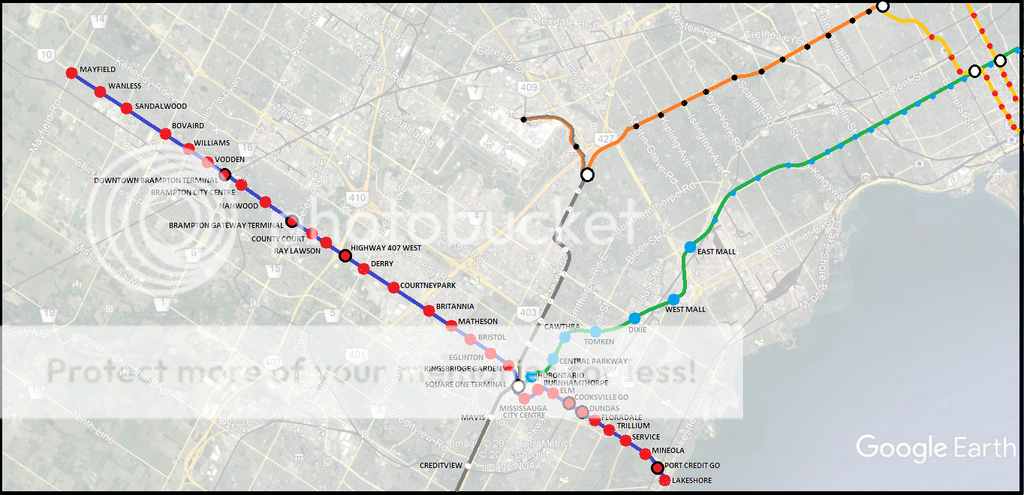
What do you have in mind for on-street, next-to-street, elevated, tunneled, and dedicated ROW construction for each segment of each project?

Bloor Danforth West Extension

Elevated:
Kipling to Dixie

Underground:
Dixie to Square One. There'd be a brief surface section between Dixie/Dundas and Tomken/Bloor parallel to Applewood Creek.

The multi-level interchange at Square One
Basement level will be the BD subway followed by the Hurontario LRT and above that lies the underground Mississauga Transitway, with vents for the bus exhaust. This will be the grandest transit hub in all of the GTA with MiWay, GO, TTC all converging here.

Hurontario LRT

Underground:
Lakeshore to Square One. In my opinion this area is too densely populated and highly trafficked for surface operations.

Surface:
Kingsgbridge Garden to Nanwood. The short section north of Charolais to Nanwood could be side of roadway through the parkalnds.

Underground:
Nanwood to Vodden. Another CBD with narrow streets and dense population where surface operations would be a nightmare.

Surface:
Vodden to Snelgrove/City Limits

Mississauga Transitway:

Fully separated from the 403 with added stations at Mavis and Creditview. Creditview Station will be situated on the south side of the 403 and will have a barrier free 500m walkway to Erindale GO station.
Most of this seems to make sense, but I disagree with your comment on Hurontario South of Square One being underground (can be underground at Lakeshore though), so it should be Hurontario on surface, bus terminal underground at Level -1, Mississauga Transitway at Level -2 and Line 2 at Level -3.
 
Bloor Danforth West Extension

Elevated:
Kipling to Dixie

Underground:
Dixie to Square One. There'd be a brief surface section between Dixie/Dundas and Tomken/Bloor parallel to Applewood Creek.


The multi-level interchange at Square One
Basement level will be the BD subway followed by the Hurontario LRT and above that lies the underground Mississauga Transitway, with vents for the bus exhaust. This will be the grandest transit hub in all of the GTA with MiWay, GO, TTC all converging here.

Hurontario LRT

Underground:
Lakeshore to Square One. In my opinion this area is too densely populated and highly trafficked for surface operations.


Surface:
Kingsgbridge Garden to Nanwood. The short section north of Charolais to Nanwood could be side of roadway through the parkalnds.

Underground:
Nanwood to Vodden. Another CBD with narrow streets and dense population where surface operations would be a nightmare.

Surface:
Vodden to Snelgrove/City Limits

If tunneling (like true tunneling not just cut/cover) I think Mississauga could be one of the most optimal locations in the GTA for it. Bedrock is really close to the surface. You can see it peeking out of the hillside from the 403 passing over the Credit, or when hiking along Etobicoke Creek. It's only a few metres below ground level.
 

Back
Top