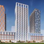
The rendering of the airport looks clearer than I've seen before. Though still not clear where the expressway could be vanishing too - and how can a GO line be running along it - on the wrong side of the highway to access the transit. Also, it doesn't match the plan-view shown - seems like an early concept, and they keep including it because it looks cool, not because it is current.
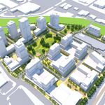
Here's the plan view. I haven't seen this before. So many questions. Given the figure is called "Regional Transit Centre and New Terminal Project Site, presumably the new terminal is the replacement for the currently Terminal 3 satellite (gates B1 to B5).
Those walkways/etc. from the new hub to the gates, now appear to be tunnel. I'm not sure what the plans are, parked along Airport Road and along (uh, under) Silver Dart. Is that just parking? Or is there a long-term plan to put gates along there as well.
So many questions. Particularly, why start the new T1, with a long term plan to extend it, and extend towards/include T1, and then make much of that redundant? It looks like a decent-enough plan, but starting again, is going to cost - and while it's all nice, they've got this massive revenue stream from the airport charges - would we be better off using the existing facilities and having lower charges. Part of me feels this looks like the existing staff trying to justify their existence - which may not be necessary as expansion and renovations end.
You could still have the transit-hub concept - and simply use it to shuttle people into the existing terminals, etc. Though give that the hub would include the location of the existing Viscount station, that's likely still part of the initial phase. Ah, yes, page 23 "transfer to existing LINK train". "LINK train, Viscount Parking Garage, and ALT Hotel are still operational.
I suppose the key question, is what is the entire initial configuration, and what is the time frame/configuration/capacity for the in-between and ultimate phases.
View attachment 124026


