News   Nov 22, 2024
 768     1 
News   Nov 22, 2024
 1.4K     5 
News   Nov 22, 2024
 3.4K     8 

Toronto Crosstown LRT | ?m | ?s | Metrolinx | Arcadis

So, today was a huge announcement for the REM, bringing it into the realm of reality (construction starts in two months!), and I just want to compare and contrast the two projects. Both have similar costs (Eglinton is $5.3 billion in $2010, $9.1 billion including maintenance, whereas the REM is $6.3 in $2017)
  • But the REM is 67 kilometers, compared to 19 kilometers for the Eglinton LRT.
  • The REM is being built to modern standards (driverless, platform screen doors, entirely grade separated). The Eglinton LRT is missing those features, which any newly built system elsewhere (in Europe or Asia) would have.
  • Whereas the REM is 100% grade separated and will achieve fast top speeds and represents massive time savings. The Eglinton LRT will run on street, stopping midblock and at red lights.
  • The REM will be entirely automated. The Eglinton LRT will cost $80 million/year to operate (in addition to the 30-year $3.8 billion maintenance contract.)
  • The REM represents a big connectivity improvement, linking the Airport, North Shore, South Shore, in routes that had not existed before. The Eglinton LRT is an improvement on an existing bus route, and did not through-route with the SRT at its end or connect to the airport.
  • I cannot find any figures for the daily ridership of the Eglinton LRT, but I am certain it is less than the 167 000 daily riders projected for the REM.
  • The Eglinton LRT has been planned in various forms since the 1960s, with construction having previously been started in the 1990s. It will be in service in 2022. The REM was first conceived about 2 years ago (although it builds off of previous proposals, e.g. for metro Line 3), and will be in service about the same time as the Eglinton LRT (2021-2022).
The REM is what GO-ALRT would have been like. Completely new travel patterns would be possible by public transit, at a fraction of the cost of normal subway development, mostly by leveraging existing ROWs.
View attachment 134415

This isn't meant to be a pissing contest, I'm just pointing out that a lot of things about the Eglinton line need a value-for-money comparison. And also take a look at how other projects have been able to rapidly go from conception to construction.

There are a couple reasons this is happening much faster for REM than Crosstown.

1. Money. With the investments REM has seen, they certainly got lucky in that regard.

2. Using old rail corridors and tunnels, as well as a bridge that already needed to be built. We had to tunnel for Crosstown, the REM has the advantage of using the Mont Royal tunnel, the Deux-Montagnes line, as well as old railway spurs to the airport and for the saint anne portion (only half of the distance runs on the Autoroute, the other half uses a rail corridor.

Also this is more line GO-ALRT, but also a modern comparison would be GO-RER.
 
So, today was a huge announcement for the REM, bringing it into the realm of reality (construction starts in two months!), and I just want to compare and contrast the two projects. Both have similar costs (Eglinton is $5.3 billion in $2010, $9.1 billion including maintenance, whereas the REM is $6.3 in $2017)
  • But the REM is 67 kilometers, compared to 19 kilometers for the Eglinton LRT.
  • The REM is being built to modern standards (driverless, platform screen doors, entirely grade separated). The Eglinton LRT is missing those features, which any newly built system elsewhere (in Europe or Asia) would have.
  • Whereas the REM is 100% grade separated and will achieve fast top speeds and represents massive time savings. The Eglinton LRT will run on street, stopping midblock and at red lights.
  • The REM will be entirely automated. The Eglinton LRT will cost $80 million/year to operate (in addition to the 30-year $3.8 billion maintenance contract.)
  • The REM represents a big connectivity improvement, linking the Airport, North Shore, South Shore, in routes that had not existed before. The Eglinton LRT is an improvement on an existing bus route, and did not through-route with the SRT at its end or connect to the airport.
  • I cannot find any figures for the daily ridership of the Eglinton LRT, but I am certain it is less than the 167 000 daily riders projected for the REM.
  • The Eglinton LRT has been planned in various forms since the 1960s, with construction having previously been started in the 1990s. It will be in service in 2022. The REM was first conceived about 2 years ago (although it builds off of previous proposals, e.g. for metro Line 3), and will be in service about the same time as the Eglinton LRT (2021-2022).
The REM is what GO-ALRT would have been like. Completely new travel patterns would be possible by public transit, at a fraction of the cost of normal subway development, mostly by leveraging existing ROWs.
View attachment 134415

This isn't meant to be a pissing contest, I'm just pointing out that a lot of things about the Eglinton line need a value-for-money comparison. And also take a look at how other projects have been able to rapidly go from conception to construction.

The Eglinton Crosstown is basically a brand spanking new subway line for the city of Toronto; it runs as a subway for a good 3/5s of its length (About the same as the Spadina line prior to the opening of the extension, which should have been aboveground for half its route). Of course it's going to be expensive and will take a lot longer; you're tunneling through midtown Toronto. It should also be noted that maintenance for the line for 30 years accounts for all construction projects/rebuilding efforts associated with the line, vehicle maintenance, tunnel and station cleaning (I believe). Considering that it's costing a fraction of what maintenance will be costing in Waterloo when compared to capital costs, it's not too bad. I am no fan of contracting out (I actually hate that about Metrolinx), but things could have been a lot worse. It's 12.5 km of subway line for about the same amount of money as the Yonge Line north extension, which is about half the length.
 
any sort of connection is physically implausible do to the condos and the subway track both being in the way of any usable tunnels.

Physically implausible??

You simply build a tunnel out of the Main Street mezzanine, under Main Street, and to the existing platform.

How is the subway track in the way of anything? I'm not sure which condos you are referring to. The Main Square apartment towers would be east of such a tunnel.

The bigger issue though is the plans to move the existing station further east, making a tunnel even longer. As usual Metrolinx has their head up their assets.
 
Do you recall how RER and REM compare in terms of stop spacing and frequency?

Stop spacing is similar.

REM is a little more frequent in some areas. More like LRT/subway frequency.

EDIT: btw, its super hard to find a map showing JUST GO-RER, not including the upgrades to the rest of the GO network, as I think Metrolinx doesn't want to point out that some lines are getting better service than others and create a downtown vs suburbs situation etc.

Y5VGx3d.png


This is basically GO-RER, because anything outside of this service area might be electrified, but won't likely be frequent subway-like service with EMU's

ZIzD8PK.png


I had to make this map showing stations and spacing. Lakeshore West line is cut off as there are no new stations along it.

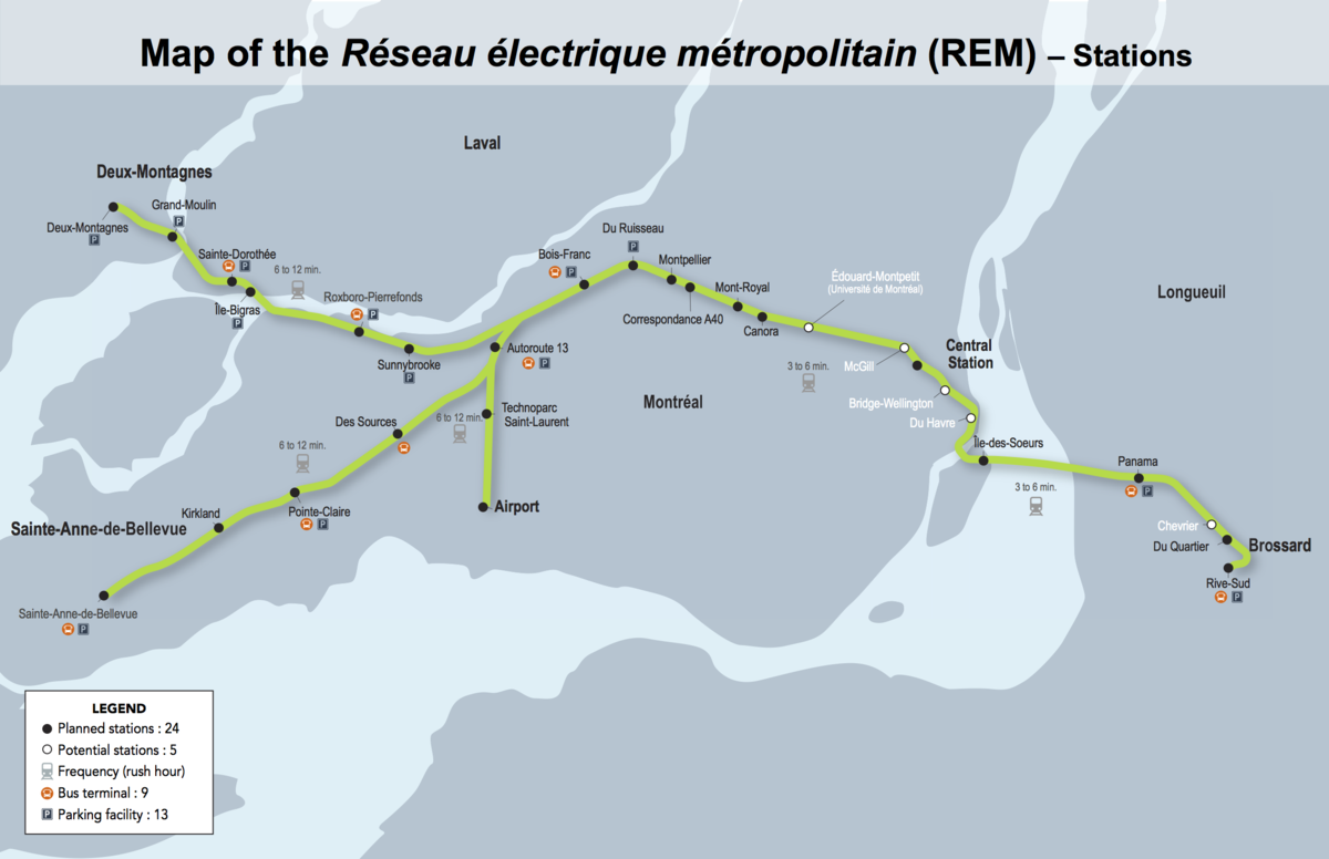
REM map

REM-map-small.png
 
Black Creek Drive Lane Closures

From link.

WHAT WORK IS TAKING PLACE?

Crews will be working within the roadway between at the intersection of Black Creek Drive and Eglinton Avenue West. There will be one (1) long-term median curb lane closure south of Eglinton Avenue and two (2) long-term lane closures north of Eglinton Avenue. This work is expected to last approximately eight (8) months.

cts_map_publicnotice_westportal_pier2final_vertical.jpg


TIMING
  • Work will occur for approximately eight (8) months, beginning as early as February 20, 2018.
  • As early as February 20, 2018 the curbs modifications for widening road turns will occur.
  • As early as February 26, 2018 the full closure of the road lines with the installation of the Jersey Barriers will occur.
  • The majority of this work will occur between the hours of 7:00 a.m. and 11:00 p.m. daily
  • Work may be rescheduled due to weather conditions or unforeseen circumstances.
WHAT TO EXPECT
  • Widening of the curbs along the northeast and southwest corner are required to facilitate truck/bus westbound right turns and provide adequate room for receiving traffic.
  • Some overnight short-term lane closures will be required for girder erection and installation. Complete closure of Black Creek Drive – two (2) nights 10:00 p.m. to 6:00 a.m. in mid-June 2018
 
Physically implausible??

You simply build a tunnel out of the Main Street mezzanine, under Main Street, and to the existing platform.
Remember the existing platform is likely to shift east in the medium term...
 
Its unfortunate that they got a shot of a freight train instead of a GO Train and UPX.

The GO train/UPX would bring better optics to the situation: make people realize what a vital connection this will be as an intermodal station.

Only transit nerds are watching this video. I’m sure we’re all aware :cool:
 

Back
Top