You are using an out of date browser. It may not display this or other websites correctly.
You should upgrade or use an alternative browser.
You should upgrade or use an alternative browser.
Tuscani01
Senior Member
A little larger for those in the back:

lrt's friend
Active Member
Considering the gates haven't work for days or weeks. Seen them a number of times with the gates being open with one or both at the same time. Give it time and we will hear of a car in the tunnel again.
Anyone using a GPS tracker needs to understand they are correct for part of your trip, depending on where you are. Have used the GPS a few time just to see how it work that it had me going in another location or wrong direction compare to what was taking place at the time. In some cases, lost me all together. Good for people who don't know how to read a map or know where they are going in the first place. Very rare I get lost going to an location I never been to before using the map. Never use the GPS while away in May that I never been to before in my 2000 mile trip. Went one way and came back another way with no problems. Have no plans to use the GPS for a 2 week trip next week.
Try using the GPS walking in Montreal last year and gave up on it quickly as it had me going the wrong direction. Considering I never been to the area before and have looked at the map before getting to my start point, knew I was going the right way without the use of the GPS and ended up in the right area.
You are so right! Just did a short motor trip between Ottawa and Georgian Bay. It was the tale of two cars both using GPS, both following two completely different routes and in our car, two GPS's basically arguing with each other since they wanted to follow different routes. At a T intersection, the GPS told us to go straight through. The other vehicle was routed through Toronto at rush hour and was delayed 3.5 hours. They were very upset. We used a map on the way home and it was a much more relaxing event-free trip without being redirected through Toronto or into the back woods. Give me a map anytime. I want to know where I am going. I don't trust GPS (I was once sent to the service entrance at Disney in Orlando with no way of finding the public entrance without a map), and then there is the possibility that they are too out of date to give proper directions anyways.
MisterF
Senior Member
Let me guess, were your friends using an old school dedicated GPS unit with no data connectivity? The problem with those is that they can't take traffic congestion into account. Under ideal traffic conditions a trip from Ottawa to Collingwood is almost as fast going through the GTA as the more direct northern route. But throw one traffic jam in the mix and it changes the game completely. All the main smartphone based map apps use data to route drivers away from traffic jams. They also offer drivers multiple routes to choose from. Like for Ottawa to Collingwood, I'm getting three routes: one through the GTA, one through Peterborough, and one through Bancroft.You are so right! Just did a short motor trip between Ottawa and Georgian Bay. It was the tale of two cars both using GPS, both following two completely different routes and in our car, two GPS's basically arguing with each other since they wanted to follow different routes. At a T intersection, the GPS told us to go straight through. The other vehicle was routed through Toronto at rush hour and was delayed 3.5 hours. They were very upset. We used a map on the way home and it was a much more relaxing event-free trip without being redirected through Toronto or into the back woods. Give me a map anytime. I want to know where I am going. I don't trust GPS (I was once sent to the service entrance at Disney in Orlando with no way of finding the public entrance without a map), and then there is the possibility that they are too out of date to give proper directions anyways.
Avoiding traffic is what I often use GPS for within the GTA, even when I know where I'm going. The fastest route could be half a dozen different routes depending on traffic. While it's not perfect, the app can tell me the fastest way, tell me about accidents or unusual traffic, and offer alternatives. A paper map can't do that.
H4F33Z
Active Member
TransitBart
Senior Member
Have you heard of “Death by GPS”?Considering the gates haven't work for days or weeks. Seen them a number of times with the gates being open with one or both at the same time. Give it time and we will hear of a car in the tunnel again.
Anyone using a GPS tracker needs to understand they are correct for part of your trip, depending on where you are. Have used the GPS a few time just to see how it work that it had me going in another location or wrong direction compare to what was taking place at the time. In some cases, lost me all together. Good for people who don't know how to read a map or know where they are going in the first place. Very rare I get lost going to an location I never been to before using the map. Never use the GPS while away in May that I never been to before in my 2000 mile trip. Went one way and came back another way with no problems. Have no plans to use the GPS for a 2 week trip next week.
Try using the GPS walking in Montreal last year and gave up on it quickly as it had me going the wrong direction. Considering I never been to the area before and have looked at the map before getting to my start point, knew I was going the right way without the use of the GPS and ended up in the right area.
drum118
Superstar
Aug 01
Had a looked at the track work in the Guild Way today and another style how track is place. Along the lines like TTC, but that's it.
The base is about 2-3' thick with dozens of various sizes of conduct ducking in it that isn't seen in TTC base. Rail is roll 300' long as I saw no splice joints like TTC does for their rail. Its either 115 or 133 and no way to measure to make sure what it was at the time. Saw no markings on it.
Some quick unfinished photos with more to Follow at some late date
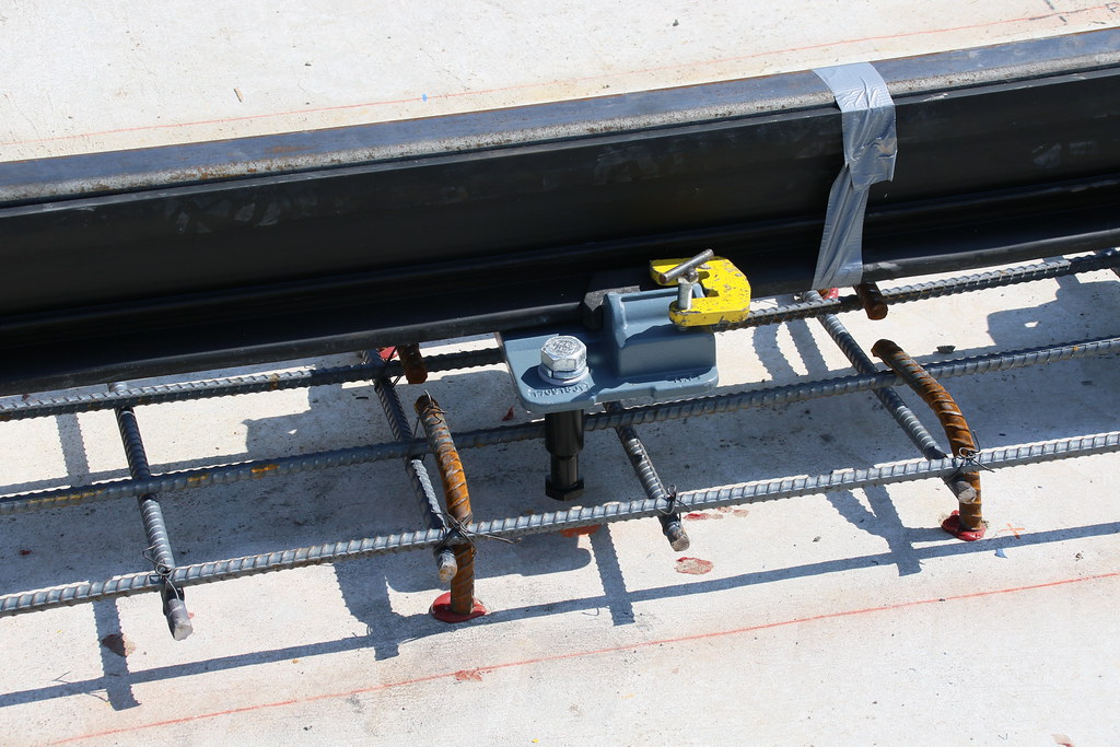
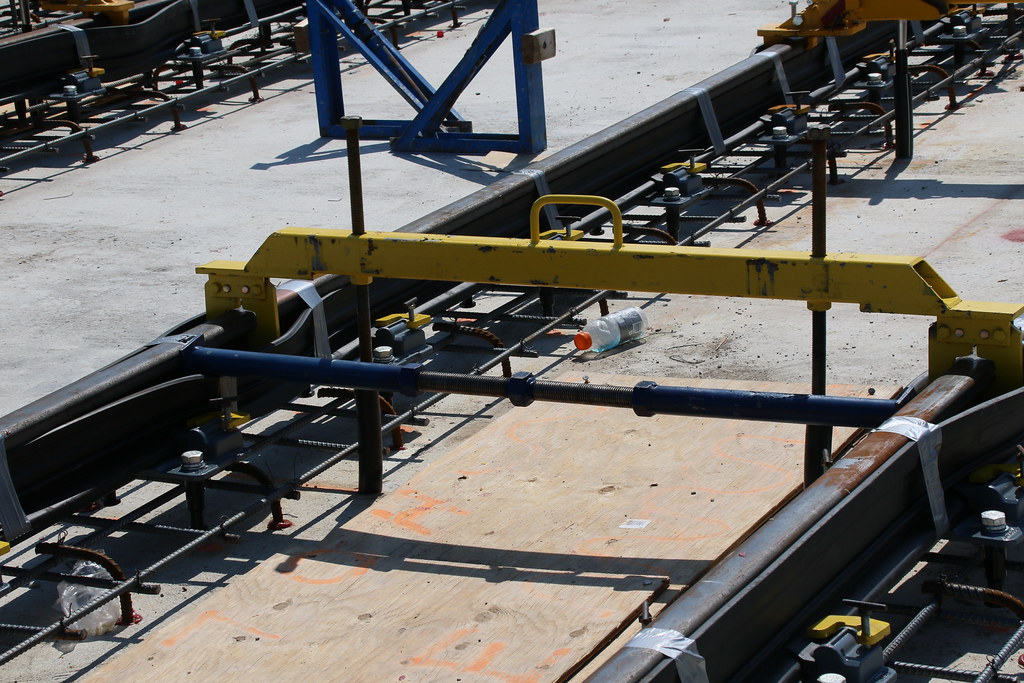
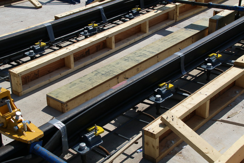
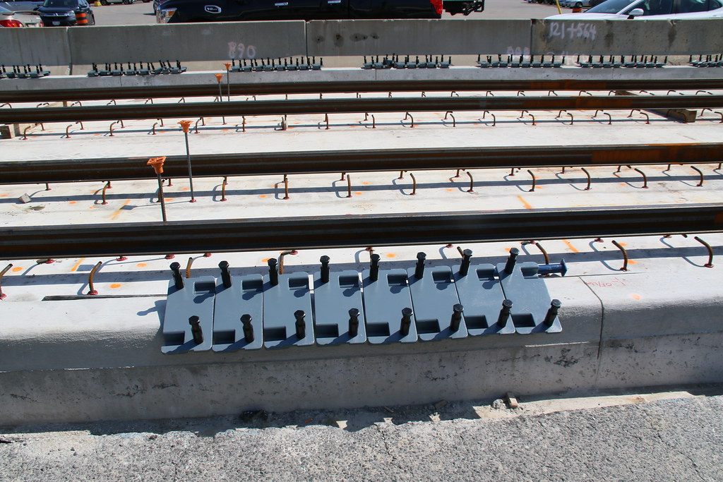


Last edited:
smallspy
Senior Member
Aug 01
Had a looked at the track work in the Guild Way today and another style how track is place. Along the lines like TTC, but that's it.
Quite a bit different than the TTC's standard, actually. This is more in line with what a lot of the modern American systems have been building of late, likely due to the consultants being used by Metrolinx to build it. You'll notice that there's no positive gauge restraining in your photos - TTC's RETRAC standard uses metal ties every 10 feet or so on tangent track (and more freqently in curves) for maintaining the gauge.
The base is about 2-3' thick with dozens of various sizes of conduct ducking in it that isn't seen in TTC base. Rail is roll 300' long as I saw no splice joints like TTC does for their rail. Its either 115 or 133 and no way to measure to make sure what it was at the time. Saw no markings on it.
Rail is 115RE, 100m lengths. Pretty bog-standard. Sections are being welded in situ.
Dan
jordanmkasla2009
Active Member
Quite a bit different than the TTC's standard, actually. This is more in line with what a lot of the modern American systems have been building of late, likely due to the consultants being used by Metrolinx to build it. You'll notice that there's no positive gauge restraining in your photos - TTC's RETRAC standard uses metal ties every 10 feet or so on tangent track (and more freqently in curves) for maintaining the gauge.
Rail is 115RE, 100m lengths. Pretty bog-standard. Sections are being welded in situ.
Dan
Further to this it's the same rail weight and cross-section as what is used on ION in KW. The most notable difference between this type of rail and what is used on the TTC streetcar network is that it's not grooved tramway track. From what I can see though, they are building the guideway differently on Eglinton than the ION. ION is metal tie secured and concrete embedded track with some transitions from and to crushed rock ballasted track on concrete ties. This allows for the median and side running sections to be traversed by rubber tired vehicles for maintenance or EMS movements. here it seems they are primarily using the same rail securement method as is used in the tunnels for the above ground sections as well.
Last edited:
drum118
Superstar
They are using the rail plate about 18-24 inches in place of TTC steel ties every 10' that are encase in a lot of rebar. The base is along TTC style, but has more (32) 6'' duct in it compare to TTC having them under the base. TTC has very few ducts and are very small. I am assuming the centre ducts are for the LRT and the rest is for hydro, cable and what every. Lots of rebar in the base compare to none for TTC. TTC Base is 2' thick in the first place.Quite a bit different than the TTC's standard, actually. This is more in line with what a lot of the modern American systems have been building of late, likely due to the consultants being used by Metrolinx to build it. You'll notice that there's no positive gauge restraining in your photos - TTC's RETRAC standard uses metal ties every 10 feet or so on tangent track (and more freqently in curves) for maintaining the gauge.
Rail is 115RE, 100m lengths. Pretty bog-standard. Sections are being welded in situ.
Dan
Not sure if if rebar will go between the rails like at major intersection, as form work shows it will be under the rail and anchor plates only. Will know more as more work is done and will not see this until We get back near the end of Aug.
As for welding rail like TTC does, my eyes must be getting bad as I never saw them in the first place, considering I was looking for them from end to end. I know what TTC splice looks like since I seen it done first hand. I know rail can be roll 300' long, but getting them from the RR site to this area will take some doing.
This style of construction is different from KW, Cincinnati, Detroit, Phil and other place I have seen first hand. NA is different from Europe. Detroit is a rebar nightmare when it come time to replace the rails.
One thing I noticed and shot is form work with tubes stubs (1') every few feet on top of the base on the east side of Pharmacy. I am assuming these are for key pockets to anchor the road or station concrete to the track work.
They are in the process of forming a thin wall (1'?) west of Kennedy Rd to Kennedy Station going under Kennedy Rd.
I found it odd that tunnel section narrows to the east of the Kennedy station to the east side of the Stouffville line. Either its a single track stub or there will be no centre wall between the 2 tracks for the extension.
smallspy
Senior Member
Further to this it's the same rail weight and cross-section as what is used on ION in KW. The most notable difference between this type of rail and what is used on the TTC streetcar network is that it's not grooved tramway track. From what I can see though, they are building the guideway differently on Eglinton than the ION. ION is metal tie secured and concrete embedded track with some transitions from and to crushed rock ballasted track on concrete ties. This allows for the median and side running sections to be traversed by rubber tired vehicles for maintenance or EMS movements. here it seems they are primarily using the same rail securement method as is used in the tunnels for the above ground sections as well.
The TTC seldom uses girder-profile rail - all of the tangent track is laid with standard "T"-profile rail like what is used here. The only place they use girder rail is on the inside of curves, to act as a guard to help keep the wheels aligned to the rail.
The rail will be fully encased in concrete when its done - that's why it's encapsulated in rubber.
They are using the rail plate about 18-24 inches in place of TTC steel ties every 10' that are encase in a lot of rebar. The base is along TTC style, but has more (32) 6'' duct in it compare to TTC having them under the base. TTC has very few ducts and are very small. I am assuming the centre ducts are for the LRT and the rest is for hydro, cable and what every. Lots of rebar in the base compare to none for TTC. TTC Base is 2' thick in the first place.
The steel ties are not the only thing used to secure the rails, just to provide positive gauge restraint and enforcement. Every 18 inches or so is a plate just like these ones that has concrete poured around and under it.
You're right about the rebar, however. It's not needed in the RETRAC system.
Not sure if if rebar will go between the rails like at major intersection, as form work shows it will be under the rail and anchor plates only. Will know more as more work is done and will not see this until We get back near the end of Aug.
It does.
As for welding rail like TTC does, my eyes must be getting bad as I never saw them in the first place, considering I was looking for them from end to end. I know what TTC splice looks like since I seen it done first hand. I know rail can be roll 300' long, but getting them from the RR site to this area will take some doing.
The TTC usually gets shorter strings that they weld at the construction site as its easier to move them around the downtown core this way. They will then get Holland or Sersa or one of any number of other outfits to flash butt weld the lengths together.
In the case of the Crosstown, they are getting longer strings of rail because it's not difficult for them to get them to the sites. Also, the process is installing the strings and then thermite welding them in place before the final layer of concrete gets poured.
This style of construction is different from KW, Cincinnati, Detroit, Phil and other place I have seen first hand. NA is different from Europe. Detroit is a rebar nightmare when it come time to replace the rails.
Philadelphia maybe, but not vastly different than the style used in Detroit, Cincinnati, Phoenix, Tampa, etc to name but a few.
Dan
Kyle Campbell
Active Member
Anyone who blindly follows a GPS into a rail tunnel, a lake, or off a cliff just makes you shake your head and wonder what where they thinking.Have you heard of “Death by GPS”?
A problem I think most people don't realize it's that the GPS signal is severely affected in areas with lots of tall buildings. At that point the accuracy starts to get to the within 300m range rather than 10m
Richard White
Senior Member
Anyone who blindly follows a GPS into a rail tunnel, a lake, or off a cliff just makes you shake your head and wonder what where they thinking.
My Aunt once followed her GPS to Peterborough when going to Courtice. She had traveled from Scarborough to Courtice weekly for years but this one time the GPS sent her off on a goose chase and she overly trusted her GPS.
Some people assume that their GPS is infallible and will actually drive off a dock into a lake following directions.
H4F33Z
Active Member
That's why every navigation app has terms and conditions that you have to agree on. Because the gps is an assist and always use personal judgement if doing something is the right decision and it's not the companies' fault if you get stranded or some other bad thing
TransitBart
Senior Member
It can be useless in downtown Toronto for this reason. I have a Garmin unit. It's on all the time. I know the city. Sometimes the unit is totally confounded by the interference.Anyone who blindly follows a GPS into a rail tunnel, a lake, or off a cliff just makes you shake your head and wonder what where they thinking.
A problem I think most people don't realize it's that the GPS signal is severely affected in areas with lots of tall buildings. At that point the accuracy starts to get to the within 300m range rather than 10m
