Coolstar
Senior Member
And 15 years since the first post.
Last edited:
And 15 years since the first post.
Why build the traffic lanes so that it would be "safe" for the speeders doing 100+ km/h, instead of narrower for the safety of pedestrians? Speed limit signs are useless.
You bring up really good points. And to answer your question, the HousingNow designs for the buildings to be built at the site include a good mix of retail use at street level. With the ample amount of sidewalk space and setbacks from said sidewalks, we might entice quite a few patio restaurants to take up residence at these locations further improving the streetscape.I don't see much speeding happening through there. There are sufficient curves, and multiple lights to pass through, that most drivers pay attention. Enough cars collect at the traffic lights to force drivers to slow or stop. No right turns allowed on red lights, which is an improvement.
And actually, the sidewalks/cycling lanes within the project zone are an oasis of safety compared to what extends from the limits of this project. All three major arterials are utterly cycling unfriendly, in every direction.
The question will be, will the quality of development create something worthwhile, or just an unremarkable precinct of high rises. No point in making an area walkable/cyclable if it's not developed to be somewhere people want to be.
- Paul
I run through this area regularly, though much less so in winter. The wider sidewalks are welcome and I guess the distinct "bike lanes" are an improvement but realistically, this reconfiguration pales in comparison to what exists in other cities, especially European cities. The entire stretch of Dundas from Mississauga/Oakville to Islington could easily remove one car lane in each direction, widen the sidewalks and add a transit/BRT lane AND protected bike lanes. The political will just simply isn't there nor is the desire to remove on-street parking along major arterials within the 416.
Metrolinx is currently planning the Dundas BRT which will do exactly that!I run through this area regularly, though much less so in winter. The wider sidewalks are welcome and I guess the distinct "bike lanes" are an improvement but realistically, this reconfiguration pales in comparison to what exists in other cities, especially European cities. The entire stretch of Dundas from Mississauga/Oakville to Islington could easily remove one car lane in each direction, widen the sidewalks and add a transit/BRT lane AND protected bike lanes. The political will just simply isn't there nor is the desire to remove on-street parking along major arterials within the 416.
5,649 days since the first post of this thread:
And 15 years since the first post.
See PDF link.I can't be the only one perplexed that it took 15 years to reconfigure an intersection?

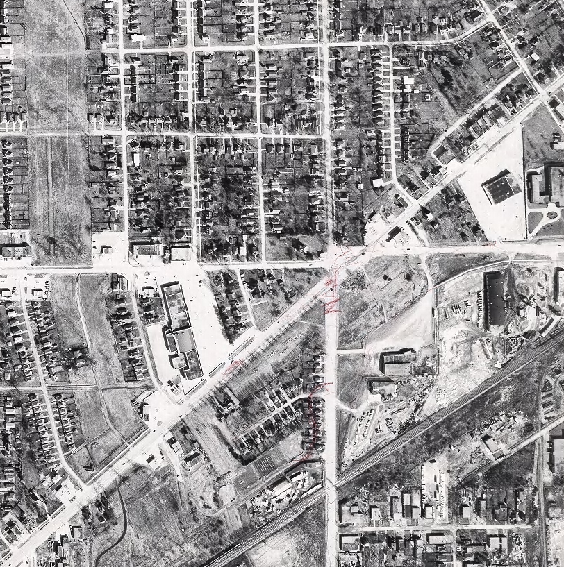
In the 1950s as suburban development mushroomed in the area, and in Mississauga further to the west, traffic built as more and more people poured along Toronto's gridded arterial roads—Kipling and Bloor—plus along Dundas, a wandering former trail that has always bucked Toronto's gridded order but which slips neatly into Mississauga's grid where it vaults over the Etobicoke Creek. With the three main streets crossing each other at virtually the same spot, and with further increases foreseen with the opening of Islington subway station—drawing many people to its commuter parking lots, kiss'n'ride, and multi-bay bus terminal—an interchange was built, starting in 1960, to handle the expected traffic.
If all you wanted for the area was smooth traffic flow, the interchange worked. Cars got through the area more quickly, and traffic accidents decreased. In 1980, however, the subway was extended to Kipling, plans to move Mississauga buses to Kipling were also considered, and plans to improve the land between the two stations began to slowly percolate. Many notions were considered over time, including using much of the area for a subway yard, but that was rejected as Toronto got more serious about a new downtown for Etobicoke without an interchange carving up the land
See link.Years worth of planning finally began to be realized when construction started in the summer of 2017, preparing the land for new roads. ...


