


Midtown Urbanist
Superstar
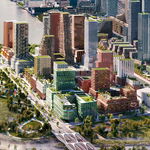
The World's Biggest Bookstore site is one step further to completing Dundas to Gerrard.
|
|
|
Wow I cannot believe I am just finding out about this thread now!
As most of you know, I have been a little obsessed with the PATH as of late. Just the other week I created a base map to plot out future PATH extensions. I extended the map north to Yorkville, west to Bathurst and east to Sherbourne. Enjoy!

Does anyone have an idea of which buildings are connected to Bloor-Yonge station?
have you never been there?
Maybe time to get out and explore the real world?No, I'm actually not overly familiar with the Bloor-Yonge area.
Salsa, that was exactly what I was looking for, thanks!
Maybe time to get out and explore the real world?
")
OK, you guys did not come through so I returned and you can walk east from Simcoe through Infinity - about 100 yards - but it's currently a dead-end. The section heading further east through ICE is not yet open (though clearly being worked on.) It looks like a perfect heated homeless haunt but it was empty, warm and clean today. I still have no idea how one would get to ACC once you pass through ICE as there is no sign of a bridge and I do not remember seeing a tunnel being built. One day ....I was walking down Lower Simcoe Street today and noticed a PATH sign on the on the new condo building on the east side of Lower Simcoe just north of L Lake Shore Blvd - Infinity. I did not have time to investigate it but the PATH map ( http://www1.toronto.ca/static_files/economic_development_and_culture/docs/BIA Maps/PATH_map.pdf ) shows this as a "future connection" going east right to the Air Canada Centre. I assume the link across (or under) York Street is not yet open. Yes?
