News   Nov 05, 2024
 302     1 
News   Nov 05, 2024
 1.2K     2 
News   Nov 05, 2024
 545     0 

Miscellany Toronto Photographs: Then and Now

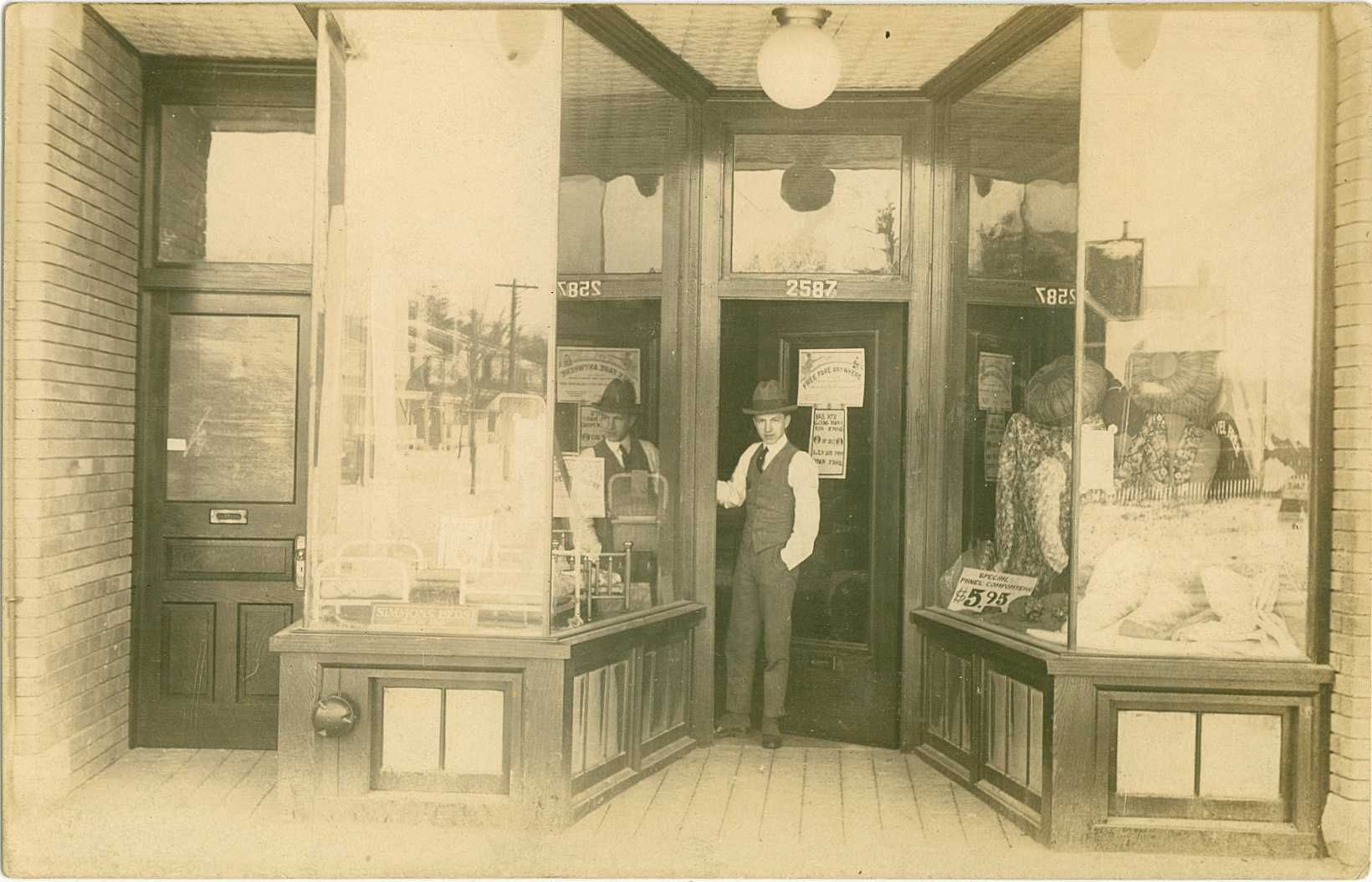
Then.

1927. 2587 Yonge Street. First time on the internets, this picture. This is UT-er Oldcamera's grandfather's shop. His gramps' shop was across the street from my gramps' laundry at 2616, so they must have at least waved to each other on occasion. How neat is that? :) Thank you Oldcamera.

1330%202587%20Yonge%20St%20in%201927_zpspfmcxkcl.jpg


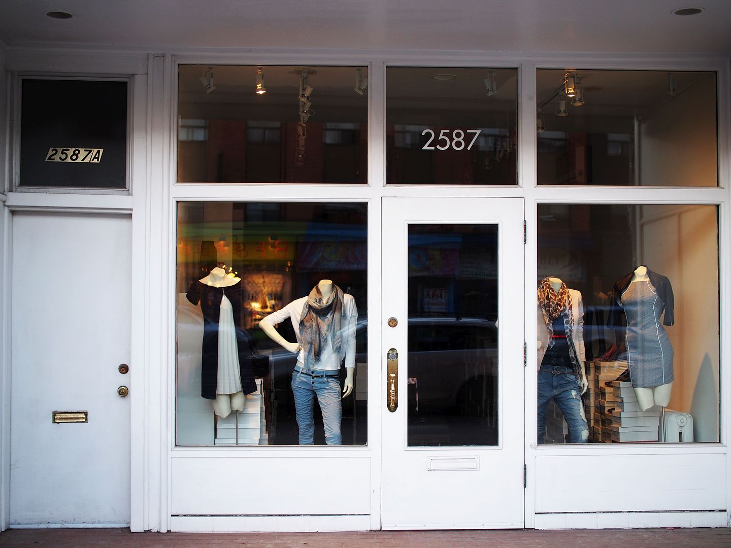
Now.

March 2015.

1331_zpsfk57pqap.jpg
 
"Yep it was a nice hat. And dressed for work in those days meant removing your jacket. Ha."
Mustapha.

Actually, the style of his hat is known as a Homburg and after taking a closer look,

it also appears as if he is wearing spats!

(BTW, spats are great for keeping your feet warm during the winter; nice, grey spats.)


Regards,
J T
 
TN Bloor St. E. looking E. from Sherbourne St. towards Glen Rd. bridge 1916.JPG
 

Attachments

  • TN Bloor St. E. looking E. from Sherbourne St. towards Glen Rd. bridge 1916.JPG
    TN Bloor St. E. looking E. from Sherbourne St. towards Glen Rd. bridge 1916.JPG
    221.4 KB · Views: 1,557

I think something may be amiss. 1916 photo shows a railway trestle whereas a google view shows no trestle at that location but Rosedale Valley Road and nothing that looks like a railway line there.
The railways do not give up trackage lightly. Closest trestle I could find is up north by Eglinton west of Don Mills.
Any ideas?
 
Not the current version, because the pictured one is more "trestle-like", while the present version's more of a leaping steel arch thing (when was it built, I wonder?)

Also, a railway trestle wouldn't have genteel globe lights.
 
It's the former Glen Road / Huntley Street bridge, when it was open to cars and connected south Rosedale to St. James Town.

electriccar-GlenRoadBridge-Toronto1912.jpg

pictures-r-5428.jpg
 

Attachments

  • electriccar-GlenRoadBridge-Toronto1912.jpg
    electriccar-GlenRoadBridge-Toronto1912.jpg
    223.6 KB · Views: 1,301
  • pictures-r-5428.jpg
    pictures-r-5428.jpg
    100.1 KB · Views: 1,224
It's the former Glen Road / Huntley Street bridge, when it was open to cars and connected south Rosedale to St. James Town.

Glen Road bridge yes, but the Huntley bridge was west of Sherbourne, and was replaced by the Mount Pleasant extension bridge.

1913:
bridges.JPG
 

Attachments

  • bridges.JPG
    bridges.JPG
    87.3 KB · Views: 1,126
the pictures of the car wreck and historic map jogged my memory

the houses in the background look familiar, and i dimly recall trying to match them to a similar old map, in a thread here on UT somewhere

my memory has had enough jogging and wants to lie down
 
the pictures of the car wreck and historic map jogged my memory

the houses in the background look familiar, and i dimly recall trying to match them to a similar old map, in a thread here on UT somewhere

my memory has had enough jogging and wants to lie down

Yes, there was some discussion about whether the bridge in the photo had been 'misidentified' and whether the view was looking north or south, and I gave a half-hearted search and...

Many Rosedale bridges here
http://wholemap.com/historic/toronto.php?neighbourhood=Rosedale

found it
http://urbantoronto.ca/forum/showth...ve-Images-of-Lost-Toronto?p=678543#post678543
 
Last edited:
Not the current version, because the pictured one is more "trestle-like", while the present version's more of a leaping steel arch thing (when was it built, I wonder?)

Also, a railway trestle wouldn't have genteel globe lights.

Yes, I agree with you. Globe lights were the deciding factor.
 

Back
Top