News   Jun 14, 2024
 1.9K     1 
News   Jun 14, 2024
 1.4K     1 
News   Jun 14, 2024
 781     0 

Miscellany Toronto Photographs: Then and Now

Movie memories

Any mention of the Donlands Cinema certainly brings back fond memories.
- see attached history photos
 

Attachments

  • Donlands theatre history.jpg
    Donlands theatre history.jpg
    92.9 KB · Views: 318
A few blocks north again and you have another lost theatre, the Donlands.
Google streetview link,

I pass this place often and regret that I never took in a show there. Goldie's nightime picture of the Donlands lit up with lights... what a jewel of a place and a loss to that neighbourhood. In my own neighbourhood, we had the Park, the Fairlawn, the Glendale and further south, the Capitol, now all gone. I go downtown to watch a show now.
 
Mustapha, here's the scene on Donlands just a block above your mentioned, Donlands & Mortimer.
I hope this post will work. Let's try!
I think I can still post images here, but I can NO LONGER VIEW any of these pages - since the "redisign" went into effect.
I'm aware of the posts only by e-mail notice - and the 'posting' software apparently still works.

TNDonlandsDairyc1960.jpg

Neat that the bungalow is still there. It's seen a few changes for sure.

Goldie, try changing or upgrading your browser.
 
The mystery usher

You're bottom row, third from the right.
Sorry, incorrect! I think I'll keep the secret.

By the way, here's how I now see these pages (attached screen capture)
Very, very hard to decipher, but I'll keep trying.
 

Attachments

  • text.jpg
    text.jpg
    24.8 KB · Views: 258
Daily Miscellaneous Then and Now for Tuesday May 17, 2011:


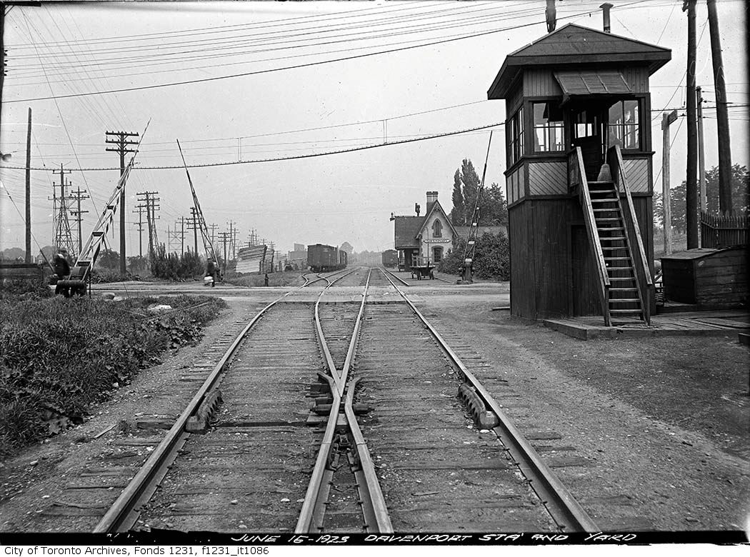
Then. "June 15, 1923. Davenport station and yard."

The street in front of us at this level crossing is Davenport Road. The rail line in front of us is the CN line that heads north to King City, Aurora and Barrie. It was originally built in 1853 as the Ontario, Simcoe and Huron railway. If I backtracked south on this rail line, it would go over Queen street west at Queen and Dufferin and head into Union Station.

In the distance is Davenport Station. 1857 to 1934-ish. I'll "walk" you up a little closer to the station in tommorrow's addition and tell you a little more about it.


f1231_it1086.jpg


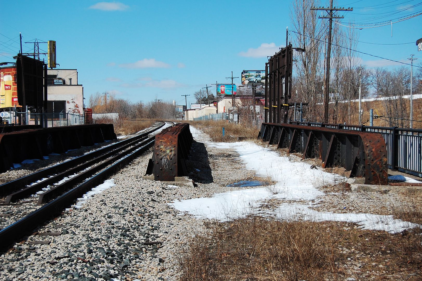
Now. April 2011. Davenport now passes underneath us.


DSC_0092-1.jpg
 
Last edited:
Sorry, incorrect! I think I'll keep the secret.

By the way, here's how I now see these pages (attached screen capture)
Very, very hard to decipher, but I'll keep trying.

Bottom photo - back row, far left?
 
Sometimes I miss my East York bungalow on Davies Cres. Alas, many are now getting second stories. Goldie, you must remember the when those houses at the south east end of the Leaside bridge had their yards "extended" with a sanitary landfill?
 
East York (Leaside) Bridge

Goldie, you must remember the when those houses at the south east end of the Leaside bridge had their yards "extended" with a sanitary landfill?

Don't know much about the "landfill" but when that bridge was completed in 1927 (much before my time!) a land-development Co. produced this booklet to sell lots in an area named "Uptown Park."
The map is very interesting (attached images).
 

Attachments

  • Uptown Park1-Pape-Donlands.jpg
    Uptown Park1-Pape-Donlands.jpg
    84 KB · Views: 304
  • Uptown Park2-Pape-Donlands.jpg
    Uptown Park2-Pape-Donlands.jpg
    89 KB · Views: 289
  • Uptown Park3-Pape-Donlands.jpg
    Uptown Park3-Pape-Donlands.jpg
    92 KB · Views: 277
  • Uptown Park4-Pape-Donlands.jpg
    Uptown Park4-Pape-Donlands.jpg
    78.1 KB · Views: 292
  • Uptown Park7-Pape-Donlands.jpg
    Uptown Park7-Pape-Donlands.jpg
    87.6 KB · Views: 292
  • Uptown Park8-Pape-Donlands.jpg
    Uptown Park8-Pape-Donlands.jpg
    56.3 KB · Views: 277

Back
Top