News   Jul 31, 2024
 16     0 
News   Jul 31, 2024
 301     0 
News   Jul 31, 2024
 278     1 

Discontinuous streets

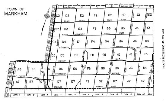
Good question. I wondered the same earlier, but they are actually Markham concessions.

1st Concession: Yonge
2nd Con.: Bayview
3rd Con.: Leslie
4th Con.: Woodbine
5th Con.: Warden
6th Con.: Kennedy
7th Con.: McCowan
8th Con.: Markham Road/Highway 48
9th Con.: 9th Line
10th Con.: Ressor
11th Con.: 11th Line
12th Con.: York-Durham Line
13th Con.: Steeles
14th Con.: 14th Ave.
15th Con.: Highway 7
16th Con.: 16th Ave.
17th Con.: Major Mackenzie
18th Con.: Elgin Mills
19th Con.: 19th Ave.
20th Con.: Stouffville Road

Don't ask me why it shifts from north-south to east-west further along the list.

Toronto/York/East York/North York uses a different set of concessions:

1st Con.: Queen
2nd Con.: Bloor/Danforth
3rd Con.: St. Clair
4th Con.: Eglinton
5th Con.: Lawrence
6th Con.: Wilson/York Mills
7th Con.: Sheppard
8th Con.: Finch
9th Con.: Steeles

I once had this explained to me by a history expert and I'm sorry I can't recall it with precision but the gist of the York system (IIRC) was that the concessions went east from Yonge and after they got to the Durham line they just rotated, and used the consistent numbering system going north on the east-west roads; so those ARE concession numbers. The sideroads are a different system.

(Oh, and can I throw in Drewery/Cummer/McNicholl as a series of name changes that's always baffled me...?)

I have to disagree with you about the last bit - the east west roads aren't concession numbers...but I can see how the numbering of the sideroads/avenues was continued from the numbering of the concession roads.

"Concession line" is principally an Ontario term for the straight country roads, parallel to one another, upon which farm lots face. They are complemented by perpendicular side roads, which together create a gridwork that covers each respective TOWNSHIP. Each rectangle of roads commonly embraces 10 farm lots of 100 acres (40.5 hectares) in size. During the 19th century era of initial settlement in Ontario, these lots were conceded (hence "concession") by the Crown to individual applicants seeking title in exchange for raising a house, performing roadwork and land clearance, and money.
http://www.thecanadianencyclopedia.com/articles/concession-line

M_2012_0_363.jpg
 
In the countryside north of Toronto, it's amusing to see east-west roads with discontinuities (i.e., you come to a north-south road, then need to travel a short distance to continue) like fault lines. There's an example on the previous post with both Elgin Mills (H2/J2) and Major Mackenzie (H3/J3).
 
There's a whole bunch of those E/W discontinuities up at the top of York Region. It messes up the transit network since there's only one easy connection between the 400 and the 404 (i.e. Green Lane), which is why York Region has repeatedly lobbied for the Bradford Bypass, but that's a whole other thread...

It can be a challenge getting to the highways once you're north of Aurora anyway.
 
Toronto (York) itself has two systems for concessions: from the bay & west/east of Yonge. So to begin with you have land concessons from Queen<-->Bloor (Concession 1 FTB), Bloor<-->St.Clair (Concession 2 FTB), St.Clair<-->Eglinton (Concession 3 FTB). Then from north of Eglinton, Yonge St. becomes the baseline and you have for example Yonge<-->Bayview as Concession 1 EYS and Yonge<-->Bathurst is Concession 1 WYS.

Scarborough has it's own system with Lawrence as its baseline and I believe Etobicoke has its own system as well but I'm not familiar with the west end.
 
There's a whole bunch of those E/W discontinuities up at the top of York Region. It messes up the transit network since there's only one easy connection between the 400 and the 404 (i.e. Green Lane), which is why York Region has repeatedly lobbied for the Bradford Bypass, but that's a whole other thread...

It can be a challenge getting to the highways once you're north of Aurora anyway.

Everything you need to know about lots and concessions in southern Ontario can be discovered here: http://digital.library.mcgill.ca/countyatlas/searchmapframes.php

In some cases streets like Yonge Street and Hurontario Street were the baseline streets with the 1st concession east and 1st concession west on either side. The further from the baseline you got the higher the concession number. The roads running east and west of Yonge and Hurontario north of Eglinton are sidelines or side roads. So for example 16th Avenue (16th sideroad) is the 16th intersection up Yonge Street 19th line is the 19th and so on. In other cases the base line was one edge of the township, usually the south, and the concessions then run east west with the sidelines running north south. In the case of York South Township (Toronto up to Eglinton) Queen Street was the baseline and the first concession was north of it.

Note that the concessions are actually the land between the roads, not the roads. North of Eglinton Bayview is the road allowance between the 1st and 2nd concession east of Yonge Street.

The jogs are there because the earth is curved.

Lastly, municipalities are hesitant to change road names because then people have to change their addresses. That's not a popular thing with voters.
 
Last edited:
The jogs are there because the earth is curved.
No ... look at the jogs - they are inconsistent and sometimes go up at one intersection and down at the other.

They either reflect the alcohol consumption of the 18th and 19th century surveyors who laid out the lots, or the technological limitations they worked under at the time. Or perhaps both :)
Even the 49th parallel is crooked:
[video=youtube;qMkYlIA7mgw]http://www.youtube.com/watch?v=qMkYlIA7mgw[/video]
 
No ... look at the jogs - they are inconsistent and sometimes go up at one intersection and down at the other.

They either reflect the alcohol consumption of the 18th and 19th century surveyors who laid out the lots, or the technological limitations they worked under at the time. Or perhaps both :)

Remember concessions were laid out pretty much using chains, and if you've ever worked with a string to lay out a lawn or garden you will know that they are prone to error. Surveyors didn't have modern gps to locate themselves either, although using the stars was fairly accurate. I feel that the chains were prone to error where either the concession was drawn slightly off center and/or that chains were pulled around trees and vegetation which could have shortened the chain.

Just my thinking.

Concessions were laid out in multiples of chains (chain =66'). 100 chains by 100 chains in many area townships was the typical - this conveniently works out pretty close to 2km by 2km. Many of those jogs were multiples of 66'. It seems they were pretty good at measuring horizontal distances. They were not as good at counting up to 100. They either layed out 101 or 99 chains instead of 100.
 
Concessions were laid out in multiples of chains (chain =66'). 100 chains by 100 chains in many area townships was the typical - this conveniently works out pretty close to 2km by 2km. Many of those jogs were multiples of 66'. It seems they were pretty good at measuring horizontal distances. They were not as good at counting up to 100. They either layed out 101 or 99 chains instead of 100.

Yup. A lot of those jogs have been worked out during the process of road widenings, but roads like York Mills and Finch have 4 or 5 jogs in them at various lines.

I just wish they would have decided to use 800m instead of 2km as the default length. It would have made creating an urban/suburban transit grid so much easier. Of course, I can understand why they did use 2x2km, but still. 800m IMO is the perfect grid size for a suburban environment.
 
What I don't understand is how an older city like New York managed to create such a perfect grid whereas Toronto failed to.
 
What I don't understand is how an older city like New York managed to create such a perfect grid whereas Toronto failed to.

Foresight?

Seriously, but I think by the time the Manhattan grid was laid out (the rest of NYC is hardly a perfect grid!) they were prepping for an urban environment. The Toronto grid was really rural by design.

Their topography was also simpler since the Toronto grid was going over rivers etc. I'm not sure what Manhattan was like when it was "wild" but I presume it was still a lot flatter than Toronto. I mean, they didn't fill in any ravines, right? We've got ravines! I don't know if Howl was joking above that the jogs are caused by the curvature of the earth but I think really topography is the culprit in most of this.
 
What I don't understand is how an older city like New York managed to create such a perfect grid whereas Toronto failed to.

Clearly you have never been in Lower Manhattan. (Also, as others have noted, Toronto has ravines that kind of get in the way of perfect 'order'. Personally I rather like the minor anarchy - though do wish Toronto had adopted the kind of numbering system used in Montreal where a street number gives one a very good idea of where the building is located.
 

Back
Top