View attachment 172767
This map is more of putting the
fantasy back in transit fantasy maps.
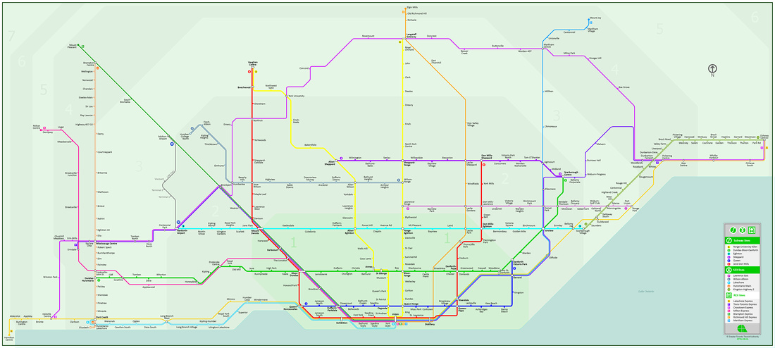
Instead of a subway route or dedicated LRT along Victoria Park, what if there was a STREETCAR that travelled on both Victoria Park and on Pharmacy? This map shows potential routes, with solid lines being the most important and dotted lines being the least important.
STOP LIST because I cannot really show it well on a map like the one I have
Southern Leg:
Main Street (Line 2), Danforth GO, Gerrard-Main, Ted Reeve, Pickering, Gerrard-Victoria Park,
Shoppers World. Possible one-stop extension to Bingham Loop.
Lawrence Proposal
Pharmacy Northbound:
Shoppers World, Albion, Donside, Bolster,
Saint Clair, Stellarton, Leahurst, Sundridge,
Eglinton (Line 5), Ashtonbee, Noreen Vernon, Surrey, Sherwood,
Lawrence.
Victoria Park Southbound:
Lawrence, Sloane, Ruscica, Elvaston,
Eglinton (Line 5), Sunrise, Parma, Tiago,
Saint Clair, Meighen, Donora, Crescent Town (Line 2), Denton,
Shoppers World.
Ellesmere Proposal
Pharmacy Northbound:
Lawrence, Galsworthy, Trestleside, Dewey,
Ellesmere.
Victoria Park Southbound:
Parkwoods Village, Cassandra, Rowena, Curlew, Deanvar,
Lawrence.
Steeles Proposal
Victoria Park Two-Way:
Ellesmere-Pharmacy, York Mills, Consumers,
Sheppard (Line 4 or 7), Huntingwood, Altair, Van Horne,
Finch, Pawnee, McNicoll, Gordon Baker,
Steeles.
(Alternatively, the northbound route tunnels under the 401 to serve Pharmacy up to Steeles.)
Rather than making this area its own development corridor, this streetcar would be more apt for increasing the catchment area of Lines 2 and 5, as well as GO service at Danforth.