This is my fantasy map(s). I was reading the Waterfront Reset report and it struck me how convoluted and confused all the different schemes were for trying to add a waterfront streetcar network, and how they didn't take advantage of a possible reorganization of the streetcar network due to the presence of the DRL. This is my response for how the waterfront network could be laid out in a way that makes sense to me.
This (
http://www1.toronto.ca/planning/3-rightofway-widths.pdf) was used in planning where ROWs were put for "Enhanced Streetcars" or for where "LRTs" were placed.
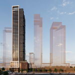
Downtown
View attachment 101242
I envision 3 new routes:
515 - Dufferin
Route:
-Follows existing 29 Dufferin route to Dufferin gates
-Turns east to service Exhibition, then goes under the Gardiner -> Fort York -> Bremner -> Union station
Grade separation:
-sufficient ROW for reserved lanes north of Lawrence
-from Fort York east, descends into a cut-and-cover tunnel (room for stations has been provisioned for in buildings along the route)
Benefits:
-upgrades busiest surface route to increase capacity/comfort
-provides long-dreamt-of Bremner LRT
-services SouthCore and big events (CNE grounds, BMO fields, Skydome)
516 - Broadview
Route:
-South from Broadview station to Unilever DRL station. Follows extension of Broadview avenue south to commissioners
-West from there to Cherry, then up Cherry ROW to terminate at Sumach DRL station.
Grade separation:
-South and West of Unilever DRL station, entire route is in separate ROW
Benefits:
-Serves Unilever development (like Southcore, new CBD planned à la Canary Wharf in London)
-people heading downtown would transfer at DRL, so route isn't indirect compared to other schemes
-provides direct route to subway for people in the portlands
509 - Harbourfront (The naming is retained but the route is different)
Route:
-West from Leslie along Commissioners, north on Cherry, west on Queen's Quay, west on fleet, terminates at Marilyn Bell Park.
-Serves entire waterfront from east to west
Grade separation:
-Entire line in ROW
Benefits:
-East/West transit link for waterfront
Toronto West
View attachment 101241
Bloor-Danforth line has been extended one station west to Cloverdale take advantage of the Cloverdale lands being offered, to allow space for a massive bus terminus with direct access to the 427. It is the logic end point for Dundas Street BRT (not pictured).
One new route:
517 - Queensway
Route:
-West from DRL Sunnyside station in Queensway ROW
-Continues along Queensway until Sherway gardens, loops at Sherway gardens
Grade separation:
-Entire route in separate ROW
-Underground connection with DRL station
-Depending on redevelopment of Sherway, above/below grade station at terminus
Advantages
-Promotes TOD in undeveloped "Avenue" without higher order transit
-Strong anchors
508 Lakeshore
This route now terminates at Sunnyside DRL station, so there is no more awkward transfer point at Humber bay between Lakshore and Queen. I found it silly how all the different EAs for WWLRT look at ways to get across the Gardiner, onto Lakshore, etc., when it makes much more sense to truncate it at the DRL and let them either A) transfer to the subway B) transfer to GO or C) transfer to the 504, which is in a transit mall through downtown.
Because the line is much shorter and is in a ROW for its entire length, service should be much more frequent and headways better managed.
Toronto North West
View attachment 101240
Salient Points:
- Dufferin upgrade to streetcar, as described above, to support intensification of corridor. Separate ROW north of Lawrence.
- 512 St. Clair ROW extended west to Scarlet Road and then south west along Dundas to terminate at Kipling station, to support the 6 point redevelopment.
- Jane LRT, rather than continuing south from Eglinton (where ROW constrains means it would have to be buried) operates as a branch of the Eglinton LRT (half of the trains from Mount Dennis continue west to the airport, half go north). Jane LRT terminates at TYSSE station Pioneer village at Steeles.
- DRL is extended north from Keele to Mount Dennis, providing service to the Junction and reactivated cross-town RER line in the process.
- Sheppard subway is continued west to Sheppard west station, where it interlines. Southbound from Vaughn Centre, half of the trains would go east at Sheppard towards Don Mills and the other half would continue downtown. This extension has the added operational benefit of making the Wilson Yards accessible to the Yonge line.
- Finch West LRT is extended east to terminate at Yonge & Finch. It's extended south and west to the airport via Rexdale (intersecting Malton GO).
- Eglinton West LRT is extended to the airport, with a maximum of grade separations. Connection to Missisauga transitway not shown.