News   Apr 23, 2024
 989     3 
News   Apr 23, 2024
 436     0 
News   Apr 23, 2024
 1.1K     0 

Yonge Street, North York Streetscape Improvements

Here's an update from the city.

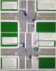
" After assessing a number of options and holding three public drop-in events and other consultation activities, the City recommended the "transform" alternative as the preliminary preferred solution. This included:
· Reconstructing Yonge Street to reduce the number of travel lanes from six to four (between Sheppard Ave. and Hendon Ave./Bishop Ave.)
· Widening sidewalks to create more space for pedestrians
· Enhancing the landscaped median
· Building dedicated cycle tracks
· Adding street trees, plantings, public art, and street furniture throughout
· Integrating public spaces with the street

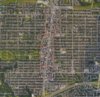
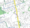
In February 2017, City Council directed staff to complete a second stage of the study that reviews the possibility of installing cycling facilities on Beecroft Road and/or Doris Avenue, rather than on Yonge Street, and Willowdale Avenue from Bishop Avenue to Steeles Avenue. We are now in Stage 2, and the project team is looking at opportunities on Yonge Street, Beecroft Road and Doris Avenue to enhance mobility and safety for all road users, including cyclists, pedestrians, transit riders, and drivers. We will be holding another drop-in event in the fall to share the findings of this phase and ask for feedback on the preliminary preferred solution. Details about this event will be provided in the near future via email, and notices will be distributed to all residents and businesses in the area.

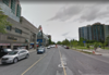
In the meantime, the project team will be conducting a further assessment of site conditions along Doris Avenue and Beecroft Road by carrying out geotechnical investigations.
 
Interestingly,... Willowdale Ave from Sheppard to Finch Hydro Corridor (Bishop Ave) was originally supposed to get bike lanes painted this summer! But that's been delayed by City Staff (Transportation Services - Cycling/Infrastructure Management Group ) who are afraid that empty Willowdale Ave bike lanes with very low cycling numbers (City staff are required to monitor and report cycling volume after installation) will negatively influence the amount and type of active/cycling infrastructure going onto Yonge, Beecroft, Doris, etc,...
 
With a series of on-going discussion from another thread,... I'll prove here that "it's about 60 to 100 times safer to place cycling infrastructure along nearby ring roads of Beecroft & Doris" VS Yonge Street between the Sheppard Ave and Finch Ave (since it's relates to this thread VS a thread about Cycling Infrastructure to downtown - NorthYorkCentre is way outside the sweetspot (1-4km) cycling distance to downtown)
http://urbantoronto.ca/forum/thread...es-headed-downtown.15478/page-91#post-1250562
http://urbantoronto.ca/forum/thread...es-headed-downtown.15478/page-92#post-1250831

One of the fundamental principles in Traffic Engineering is conflict points of path between different road users (pedestrian, cyclist, vehicules) and within each of these modes especially with different traffic movements (turning traffic vs straight traffic). Traffic engineering focus on number of conflict points, severity (head-on, T-bone), traffic volume, visibility, etc,...

IMG_4564.JPG

https://safety.fhwa.dot.gov/ped_bike/tools_solve/fhwasa12018/


If you're not familiar with NorthYorkCentre or just want to confirm data (AmnesiaJune), use GoogleEarth and their Ruler tool.

In North York Centre, the road grid system favours east-west side streets which generally intersect Yonge Street in close proximity of every 80m.

Within the ReImagining Yonge Street Study's primary subject area of Sheppard Ave to Finch Ave, there's about 20 east-west streets from each of the single residential house neighbourhood that surrounds the North York Centre Secondary Plan area (Yonge cooridor), but only 2 of these east-west street (Empress/ParkHomes & Churchill/Church) (highlighted below in green) actually goes through to intersect with Doris, Yonge and Beecroft. In other words, 90% of these east-west street (highlighted below in Yellow) "dead-end" or "loop-out" before ever reaching Doris or Beecroft; the interesting side effect is the pedestrian sidewalk along west side of Beecroft and east side of Doris are very long and continuous without any pedestrian-vehicle conflict point!!! (highlighted below in red with measurement in red) Typically 500m, 650m and 850m long continuous sidewalk,.... placing new bi-directional cycling infrastructure along west side of Beecroft and east side of Doris to mirror these long continuous sidewalk would result in cycling infrastructure with long continuous RightOfWay for 500m, 650m and 850m without cyclist-vehicle conflict points!!!
YongeCorridorNYC3dT_Good_OrangeGreenRed_measure.jpg

Note: West side of Beecroft is the stronger candidate VS east side of Doris, but push is to get both,... as part of larger design.

Since there are cyclist-vehicle conflict points generally every 80m along Yonge Street; cycling infrastructure along west side of Beecroft & east side of Doris would be about 6 to 10 (500m/80m to 850m/80m) times safer than Yonge Street! (Or as AmnesiaJune would phrase 600% to 1,000% safer than Yonge). BTW, based on this magnitude of this safety factor alone, the proposed Yonge Street cycle tracks should be killed.

But I'm not done yet,.... Now let's focus on number of Cyclist-Vehicle conflict points (ie: intersections);
- between Sheppard and Finch Ave, along west side of Beecroft Road there's only 2 city street (Churchill Ave & ParkHomes Ave) intersecting Beecroft Road
- between Sheppard and Finch Ave, along west side of Yonge Street there's 11 city street intersecting Yonge Street
Thus, west side of Yonge Street has more than 5 times the number of Cyclist-Vehicle conflict points than west side of Beecroft Road.
This means, cycling infrastructure along west side of Beecroft would be about 30 to 50 (6x5 to 10x5) times safer than Yonge Street! (Or as AmnesiaJune would phrase 3,000% to 5,000% safer than Yonge).

But I'm still not done yet,.....

Continue,....
 

Attachments

  • IMG_4564.JPG
    IMG_4564.JPG
    1.5 MB · Views: 496
  • YongeCorridorNYC3dT_Good_OrangeGreenRed_measure.jpg
    YongeCorridorNYC3dT_Good_OrangeGreenRed_measure.jpg
    506.4 KB · Views: 512
Last edited:
Continue,.....

Now lets focus more on the cyclist-vehicle conflict points themselves - at the intersections!
- Along Beecroft & Doris, practically all cyclist-vehicle conflict points are at current or future signalized intersections where you have red (stop), green (go) or yellow (stopping) light - no ambiguity
VS
Yonge Street where the majority of cyclist-vehicle conflict points are at in-signalized intersection (stop sign only for side street), where vehicles coming out of side streets are constantly jerking forward looking for gap in Yonge St traffic. Here, cyclist are at mercy of driver's (often poor) judgement.
- Yonge corridor full of high density development producing higher volume of turning traffic onto Yonge Street
VS
west side of Beecroft & east side of Doris service low density residential neighbourhood with lower traffic turning volume
- Side street along Yonge St have higher volume and percentage of turning traffic (more accident prone traffic movements - right hook, left cross, pull out) VS Beecroft & Doris
- Along Yonge Street, building structure built out to City's Right of Way reduces sight line visibility for cyclist & drivers looking for turning traffic,...
VS
more open space intersections along west side of Beecroft & east side of Doris creating better visibility
- Yonge Street is full of distractions and more pedestrian traffic volume and unpredictability
- exhaustive stop & go cycling on Yonge Street with much higher cyclist-vehicle conflict points create exhaustive stressful cycling where cyclist are more prone to mistake (their's or drivers')
VS
long continuous relaxing cycling on Beecroft & Doris with more greenspace

Previously, already established that cycling infrastructure along Beecroft/Doris would be about 30 to 50 (6x5 to 10x5) times safer than Yonge Street! Using risk management, factoring in the above issues, my initial 60 to 100 times safer range would seem,... conservative! This exercise easily shows cycling infrastructure along west side of Beecroft & east side of Doris would be about 60 to 100 (6x10 to 10x10) times safer than Yonge Street! (Or as AmnesiaJune would phrase 6,000% to 10,000% safer than Yonge!!).

BTW, we haven't even discussed or factor in the design itself yet,.... along west side of Beecroft Ave and east side of Doris Ave there's more room to properly design much safer cycling infrastructure,..... and all this can be done without mitigating any other risk factors to surrounding neighbourhoods!

AmnesiaJune, you just got "schooled"; but that's ok, the City's traffic engineers and their consultants got "schooled" in traffic engineering,... in front of senior City Staff and Councillors!


Now what will be interesting, outside special interest groups like CycleToronto & David Suzuki Foundation (and even some senior staff within City Planning & Transportation Services) have continued to push of Yonge Street Cycle Tracks as part of Minimum Grid, Major Corridor Study, Complete Streets, etc,... but with 60-100 times (or as AmnesiaJune would phrase 6,000% to 10,000%) safer cycling infrastructure being proposed on Beecroft & Doris alternatives,... these special interest groups would be hypocritical,.... especially since they're the ones pushing for VisionZero!!!
 
Last edited:
Responding to BMO interesting insights here,...
http://urbantoronto.ca/forum/thread...es-headed-downtown.15478/page-92#post-1251317

It's probably (insert figure) safer because of volume and lane width and speed. As soon as a roadway has less volume that automatically translates into less potential conflicts between cyclists and motorists. Mind, you, safety isn't the only reason that determines where bike lanes should be placed. You want the bike lane to be used hence why many city's opt to put them on major corridors so that there is easy access to shops and stores (spur foot traffic/bike traffic to these locations). Having a bike lane on an alternate street that requires cyclists to still end up on the major corridor to access shops and services negates safety advantages (for instance).

It depends on the corridor and what type of usage it is likely to see. If most trips are expected to be pass-through trips then shifting the route to a lower volume corridor would likely yield better results, but if the route is expected to operate to serve local destinations/trips then having it closer to the action and trip generators would likely yield a better result, despite a potentially more dangerous alignment on Yonge St.

Keep in mind I'm literally just talking out loud and have no data to back-up any of these hypothetical scenarios.

Pursuing the more dangerous alignment along Yonge Street should have less probability especially since the City has officially adapted a VisionZero policy.

While, there are "destinations" along Yonge Street,.... they're mainly TTC subway stations for cyclist coming east-west from the single residential house neighbourhood; which won't be serviced by a north-south Yonge Street cycle track.

The "destination" argument for Beecroft/Doris is,... Where's North York Civic Centre? 5100 Yonge but it's so far off Yonge it's physically on Beecroft Road, as is the attached Douglas Snow Aquatic Centre, as is Toronto Center For Arts to south, as is North York Central Library to north,.... all there are "Community Hubs",.... along with other "community hubs" like churches, community centres, St.Cyril Catholic School, parks, etc,... all along Beecroft Road. Along Doris, "Community Hubs" are schools like McKee Elementary School (across street from MitchellFields Community Centre), Cardinal Carter Secondary School, Claude Watson School for Arts, nearby Earl Haig Secondary School, parks,....

Clearly, to build beneficial cycling infrastructure to serve the North York Centre community, it must connect the "community hubs" which are primarily along Beecroft & Doris.

Along Yonge Street, North York Centre has "retail destinations",... many of the larger "retail destinations" like Yonge-Sheppard Centre, EmpressWalk Mall, North York City Centre, EmeraldPark mall are so large, they're easily accessible from Beecroft & Doris!

Note: It'll be very unlikely to ever see a school kid ride their bike to school along Yonge Street cycle tracks,.... why? Because for safety reasons, Yonge Street is generally the school boundary! But you'll see school kid ride on Doris & Beecroft,... where their schools are!!!
 
Last edited:
Responding to Salsa here,....
http://urbantoronto.ca/forum/thread...es-headed-downtown.15478/page-93#post-1251740

Sunnyray, I understand the safety argument, but Beecroft and Doris are short little roads that exist only between Finch and Sheppard. Beyond that, where else are cyclists supposed to go other than on Yonge Street? Would you advocate for no bike lanes north of Finch too based on the same arguments?

Regardless of whether cycling infrastructure goes on Yonge or (Beecroft and Doris - note 2 is always better than 1); to the north it'll directly connect to existing Finch HydroCorridor Trail, to the south it'll be close to proposed Highway 401 crossing linked via Linelle Street (Not Yonge) as part of City's 10 year bike plan but need to deal with MTO (PITA since MTO already stalling for decades on any Yonge-401 improvements!).

The proposed Yonge Street cycle track is a proposed straight through thoroughfare that would not benefit the local residents much, would cause traffic chaos and havoc for local businesses.

With cycling infrastructure along Beecroft Road and Doris Ave as part of a larger design, its much more beneficial to local community and residents. Wait until you actually see the design this Fall; the design is essentially a centre-piece design that has the high density North York Centre area as it's centre and can be built out.

Yes, I HAVE been advocating for no bike lanes on Yonge north of Finch too based on the same safety arguments (aka the Beecroft/Doris is 60-100 times safer safety argument) since Beecroft & Doris will both eventually be extended north of Finch Hydro Corridor with similar road design as in North York Centre Secondary plan ("dead-end" and "loop-out" east-west side streets). As per the Yonge Street North Secondary (conceptual) Plan, when Beecroft and Doris are extended north, they will have cycling infrastructures.
 
Last edited:
Responding to AmnesiaJune here so all ReImagining Yonge Street Study post are kept together,...
http://urbantoronto.ca/forum/thread...es-headed-downtown.15478/page-93#post-1251764

Playing devil's advocate here, the bike lane project is only running from Avondale to Bishop/Hendon (four blocks south of Sheppard to one block north of Finch). The city doesn't have any plan to add bike lanes north of there, and there likely won't be any until the subway is extended and the bus/carpool lanes are no longer needed.

Last year, ReImagining Yonge Street Study was supposed to look at cycling infrastructure along Yonge north of Finch Hydro Corridor to Steeles this summer,.... but obviously that's been post-pone/cancelled due to outcome of original ReImagining Yonge Street Study to the south.

Also note, while Yonge Street from Finch Hydro Corridor to Steeles seems wide,... due to open roadway and plaza with parking along Yonge street, the City's Right Of Way property is more similar to the narrower parts of Yonge Street in older parts of North York Centre to the south.

Keep in mind, Yonge Street from Finch Hydro Corridor to Steeles has been basically untouched, there's really no recent large development (except a couple just north of Finch Hydro Corridor),... the high density apartments are from before the 1980s,.... before the city started insisting developer convey (give up) strips of Yonge Street frontage land for wider pedestrian sidewalks,....

So far, it's taken 40 years of North York Centre Secondary Plan (401 to Finch Hydro Corridor) to result in about 70% redevelopment within and wider pedestrian sidewalk on about 70% of Yonge Street, and even now, it's technically difficult to shoe-horn in the proposed cycletrack without taking away existing pedestrian sidewalk space in some area. Another reason for City to stall Yonge Street North Secondary Plan development would be to get as much redevelopment in the remaining 30% of North York Centre Secondary Plan area (especially, inbetween subway station areas that often has narrower pedestrian sidewalk due to lack of redevelopment).

As this Yonge Street North Secondary Plan (Finch Hydro Corridor to Steeles) area develops, the priority will be for wider pedestrian sidewalks along Yonge Street to service the new development and residents; thus any road narrowing will go towards wider pedestrian sidewalk.
 
Last edited:
Just making a note of BMO's insightful post I promise to respond to here once Beecroft & Doris designs are out
http://urbantoronto.ca/forum/thread...es-headed-downtown.15478/page-93#post-1251821

You make some good points. And they are based on engineering principles. However, we must acknowledge that those two corridors (Beecroft/Doris) have basically zero trip generators on them and that a tremendous amount of high-density residential development is centred on Yonge Street. This creates a scenario where you're naturally going to have more people (who could potentially bike or walk or drive or take transit) start or end their trips along Yonge Street. This would require good and frequent East-west connections to Yonge Street (from your proposed corridors) to provide a safe environment for these people as well. I would imagine the overall investment required for this would be substantially more than along Yonge St.
If you were to do a cost-benefits analysis between the three corridors i'd imagine you'd see positive impacts on ridership, and convenience for a Yonge St alignment, but negative impacts on cyclist safety when you compare them side-by-side. However, investments are made based on multiple factors, one of which is safety. This calls to question what is an acceptable safety standard for cycle tracks? Is it zero deaths for every 100,000 cyclists? is it five? It is virtually impossible to prevent conflicts 100% of the time, but there is a point where you can balance the expected safety risks with other factors. In my opinion I would say that cycle tracks or lanes on Yonge St could probably be designed and implemented in a way that mitigates safety risks to an acceptable level while simultaneously promoting a shift toward sustainable modes of transportation (Cycling, walking, transit) that improves the utilization of cycling facilities in the area.
 
Official notice from City about 3 weeks ago,...
https://www1.toronto.ca/City Of Toronto/Policy, Planning, Finance & Administration/Public Consultation Unit/Studies/Transportation/Yonge St North Revitalization Study/REimagining Yonge PIC 4 Notice.pdf

The above Community Consultation meeting will likely focus on getting community feedback on possible solutions; another Community Consultation meeting will be in late November or early December (not set yet) and then City Staff recommendation to Public Works & Infrastructure Committee (not City Council as per that InsideToronto article) in January 2018.
 
My previous posts clearly established the safety of "placing new bi-directional cycling infrastructure along west side of Beecroft and east side of Doris to mirror these long continuous sidewalk would result in cycling infrastructure with long continuous RightOfWay for 500m, 650m and 850m without cyclist-vehicle conflict points" (VS the "6,000 to 10,000%" more dangerous Yonge Street cycle track with cyclist-vehicle conflict point about every 80m).
http://urbantoronto.ca/forum/thread...scape-improvements.25913/page-12#post-1251574
http://urbantoronto.ca/forum/thread...scape-improvements.25913/page-12#post-1251575
YongeCorridorNYC3dT_Good_OrangeGreenRed_measure.jpg

Benefit of Beecroft and Doris includes all the community hubs and parks along Beecroft and Doris,....
http://urbantoronto.ca/forum/thread...scape-improvements.25913/page-12#post-1251576


I've proposed more inclusive Off-Road Multi-Use Trails (not just for cyclists only but also joggers, runners, rollerbladers, skateboarders, etc,... only 0.5% local cycling share mode primarily from single residential house area and lots of joggers from condos) along west-side of Beecroft Rd (Finch Hydro Corridor to Poyntz Ave) and east-side of Doris Ave (Finch Hydro Corridor to Sheppard then Avondale Ave via Doris south extension) where there's plenty of left-over green space from dead-ending & looping out side streets (from single residential home neighbourhoods) along with plenty of parkettes and parks from Section 37 Community Benefits and Parkland dedication from all the developments of North York Centre Secondary Plan area. This will be like Martin Goodman (off-road) multi-use trail with pedestrian sidewalk nearby and opportunity for exercise machines (fitness circuit), more playgrounds, BBQ/picnic tables, benches to improve public realm & utilization of open greenspace along Beecroft & Doris.


As BMO correctly mentions, "This would require good and frequent East-west connections to Yonge Street (from your proposed corridors) to provide a safe environment for these people as well."
http://urbantoronto.ca/forum/thread...scape-improvements.25913/page-12#post-1251875

Don't worry,... the solution I submitted to City had plenty of east-west (multi-use trail) connectors,... about 6 in addition to the Finch Hydro Corridor east-west connector City already committed to,... any east-west street where there's current & planned signalized intersection along Beecroft Rd, Yonge St and Doris Ave (generally every 200m,... except Sheppard & Finch since they're major arterial roads that suffers same issues faced with cycling infrastructure on Yonge Street and they're even more dangerous since they both have busy TTC bus terminals). Most east-west connectors along north side and generally away from heavy left turning traffic,... very safe since basically all crossing of the off-road multi-use trail will be at current or planned signalized intersection (avoiding dangerous in-signalized crossings where judgment call of anxious driver & cyclist).

OuterRingRoadsMultiUseTrails9a.jpg


Whereas Martin Goodman Trail is linear trail, this will be a centre-piece active infrastructure (multi-use trail) design that encapsulates the high density North York Centre Secondary Plan area with a series of circular off-road multi-use trails encouraging local residents and workers do a variety of exercises while staying and exploring this area (VS making a beeline out). This solution essentially gives the condo residents of North York Centre a backyard to exercise and play in!

The benefit of Off-Road Multi-Use Trail is connectivity:
- to north, existing Finch Hydro Corridor Trail to the north is already Off-Road Multi-Use Trail
- to west, York Cemetery treated by locals as multi-use trail and will connect to existing off-road multi-use trail in large and scenic EarlBales Park
- to south, proposal for off-road multi-use trail at Yonge-401-DonValley - part of it already in City's 10 Year Cycling Plan while some other parts require more discussion with MTO
- to east, possible Don Valley East connector but likely require rebuild of part of Wilket Creek storm water infrastructure under 401 which won't be likely until a couple of decades (bean counter at City Hall afraid of liability issue if used with current storm water runoff design)
- to north, conceptual model of Yonge Street North Secondary Plan (north of Finch Hydro Corridor) include similar off-road multi-use trail network as Beecroft Road and Doris Ave expands northward


While this proposal is for off-road multi-use trail that would not eliminate any traffic or parking lanes along Beecroft, Yonge or Doris,.... some City Staff / Consultant & Councillor Filion still looking at decreasing Yonge Street traffic/parking lane from 6 to 4 (not including centre turn lane) to widen pedestrian sidewalk (already very wide usually); I'll be proposing 5 lanes (not including tree lined centre median / centre turn lane),...


As always, constructive comments, feedbacks, questions and suggestions are welcome,... and as usual, the usual trolls ignored.
 

Attachments

  • YongeCorridorNYC3dT_Good_OrangeGreenRed_measure.jpg
    YongeCorridorNYC3dT_Good_OrangeGreenRed_measure.jpg
    506.4 KB · Views: 437
  • OuterRingRoadsMultiUseTrails9a.jpg
    OuterRingRoadsMultiUseTrails9a.jpg
    486.9 KB · Views: 502
Last edited:
As always, constructive comments, feedbacks, questions and suggestions are welcome,...

Couple of questions,

- to south, proposal for off-road multi-use trail at Yonge-401-DonValley - part of it already in City's 10 Year Cycling Plan while some other parts require more discussion with MTO

The Yonge-401 "bypass" idea pushed by Cycle Toronto included a trail connection under the 401 to Yonge Blvd, which is not shown in the 10 year plan. Is that proposal dead or unfeasible at this point, or is there still talk behind the scenes?


Capture2.PNG


About the east-west connecting streets (sorry if I missed the answer to this), what else is special about them besides just having traffic signals? Will they also have bike lanes or multi-use trails? Because these streets as they exist today feel more like arterial roads and are definitely not safe for cyclists. Furthermore if the city is serious about making Yonge St more pedestrian friendly, these side roads must be shrunk drastically. Just a reduction in crossing distance alone would be a huge improvement.


Capture.PNG


Capture3.PNG
 

Attachments

  • Capture.PNG
    Capture.PNG
    1.3 MB · Views: 847
  • Capture2.PNG
    Capture2.PNG
    341.7 KB · Views: 563
  • Capture3.PNG
    Capture3.PNG
    1.1 MB · Views: 782
The Yonge-401 "bypass" idea pushed by Cycle Toronto included a trail connection under the 401 to Yonge Blvd, which is not shown in the 10 year plan. Is that proposal dead or unfeasible at this point, or is there still talk behind the scenes?

Actually,.... that original Yonge-401-DonValleyWest ByPass Multi-Use Trail solution "pushed by Cycle Toronto",... is my idea! CycleToronto's Yonge Street Working Group just made an unauthorized youtube video of it without giving me full credit,.... that's called plagiarism, intellectual property theft, etc,...

Anyways,... the main centre-piece of my Yonge-401-DonValleyWest ByPass Multi-Use Trail solution is utilization of lower deck level of existing Highway 401 Hoggs Hollow Bridge for multi-use trail usage,.... I've been in discussion with various City Staff, local area Councillors, Provincial MPPs, community groups and even Federal MP over the years and they generally like the idea but the Highway 401 Hoggs Hollow Bridge itself is Provincial MTO infrastructure,... thus, City needs to get approval from MTO for any such usage. City is committed and focused on the near Yonge at separate grade crossing of 401 via existing dirt MTO service road near eastern valley ridge as shown in City's 10 Year Cycling Plan,... this requires MTO approval since its their infrastructure. With these discussion, the other segments like lower deck of Hoggs Hollow Bridge will be discussed as well,.... but City see them as longer term dependent on how demand for cycling infrastructure (multi-use trail) in the area materialize. NOTE: MTO now has CycleON policy guidelines for cycling infrastructure near MTO infrastructure,..... so that helps.


About the east-west connecting streets (sorry if I missed the answer to this), what else is special about them besides just having traffic signals? Will they also have bike lanes or multi-use trails? Because these streets as they exist today feel more like arterial roads and are definitely not safe for cyclists. Furthermore if the city is serious about making Yonge St more pedestrian friendly, these side roads must be shrunk drastically. Just a reduction in crossing distance alone would be a huge improvement.

View attachment 123921

View attachment 123926

The east-west connectors are conceptualized as Off-Road Multi-Use Trails to match the Off-Road Multi-Use Trails along west side of Beecroft and east side of Doris Ave.

As per your first photo, there's plenty of room along north side of ParkHomes Ave to host off-road multi-use trail,... not just in GibsonPark but along grassy boulevard between curb and sidewalk.
NOTE: that south side of ParkHomes Ave is a pet-peeve of mine,... the pedestrian sidewalk are hidden in the colonnade,.... where drivers don't expect it to be!!! Very dangerous for pedestrian,.... let's try to get that sidewalk rebuilt outside of the building!!!

As per your second photo, there's plenty of room along north side of North York Blvd to host off-road multi-use trail,... along grassy boulevard. Keep in mind North York Blvd is ridiculously wide with 2 eastbound lanes, 2 westbound lanes and 1 centre left turn lane,.... 5 lanes of traffic for a road that's only 200m long!!!! WTF,... when is there ever traffic congestion on North York Blvd???? Are cars and people just lining up here "just dying" to get into the cemetery???? This is one of the 2 streets (of 6 east-west connectors) where I recommended lane removal.

From your first photo, I don't recommend any lane reduction along ParkHomes Ave & Empress Ave (likewise Churchill&Church Ave) since they're one of 2 feeder streets between Yonge and single residential neighbourhoods east and west of North York Centre between Sheppard & Finch, as per first photo of my previous post.

Note: Officially, City Staff and Consultants only considering Beecroft, Doris & Willowdale in addition to Yonge,.... for cycling infrastructure,.... but east-west connectors are within Study Focus Area so they're seriously considering it. How much? We'll see.
 
Last edited:

Back
Top