News   Apr 19, 2024
 411     0 
News   Apr 19, 2024
 577     2 
News   Apr 19, 2024
 965     3 

Waterfront: Port Lands Consultation

Thanks, AoD

So what it seems is that the realigned/revised 4WS plan is the biggest change. As I posted in the previous thread, the key reason for the loss of the large, naturalized delta/estuary/mouth seems to be logistics. Namely, that it will interfere with the active shipping zone of the Inner Harbour. It's for this reason that we aren't seeing any built promontory jutting out from the mouth (or from any land facing the Inner Harbour) .

A loss, yes. But things are looking good. I'm hoping the city will have a strong demand when the Lower Don Lands is complete. It'd be a shame to have this excellent area sit undervalued due to a poor market. Same goes for the East Bayfront, which either will be near-completion, or completed once the LDL is ready for property development.

Growing up next to the Don Valley, it is disheartening to see the proposed meandering river narrowed on its way to the mouth. But I guess that's the price of progress and development. But this is clearly better than the Don being channeled in a concrete confinement.
 
Last edited:
But I guess that's the price of progress and development.

No it's not. You saying that reminds me of what "progress" looked like in the 50s. Progress and development and renaturalisation of the mouth of the Don as originally envisioned are not mutually exclusive contrary to what a bunch of over-the-hill politicos might think. I can almost admire your optimism were it not for the fact that I think your optimism is the kind that lets things like this go awry. Oh, and please don't take this personally, I understand you're just saying what boatloads of others are thinking.
 
Well, what are the savings from narrowing the river? $150M? That's fairly substantially, especially considering WT's large number of other projects - many of which are unfunded and up in the air (e.g the streetcar project). We aren't really flush with cash at the moment.

I don't want the Don channeled in a man-made confine by any means. However, I am having trouble grasping the concept of having a wetland in a built urban zone. Especially when the river in question is Canada's third most polluted. I don't know what to think. I know every nook and cranny of the Don Valley south of Eglinton, so this issue does hit close to home. I haven't dwelt on how big of an impact the changes are to be; but am under the impression we will see many more changes in the coming years. The EAs are ongoing, and the original plan was never written in stone (as can be seen by the necessary loss of the river mouth promontory).
 
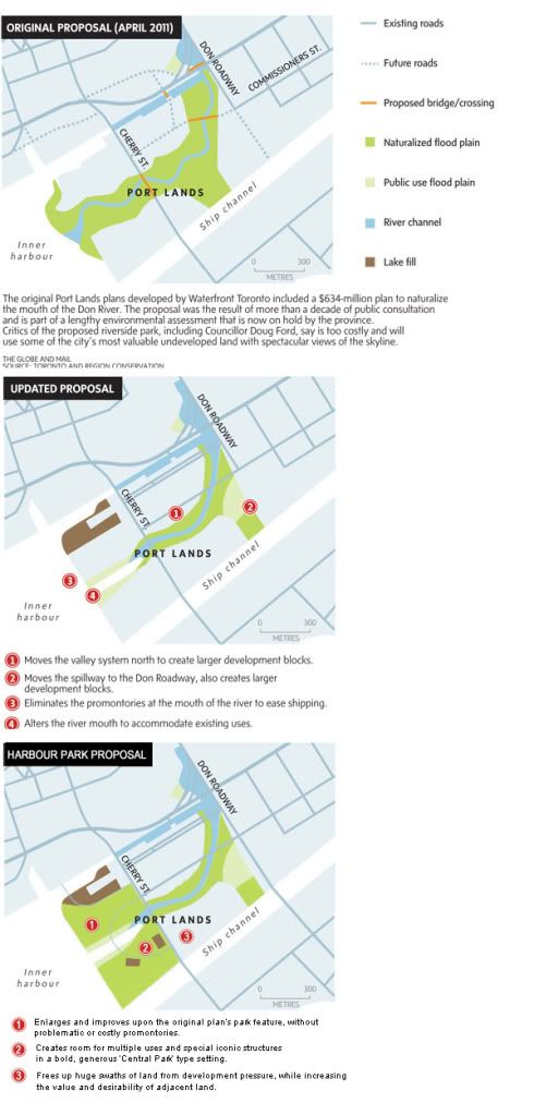
The cost and difficulty of altering the concrete retaining dockwalls, and the concern over the impact of the promontories might have on inner harbour shipping seem to be the two big issues. Still, I don't see why it has to lead to a reduction in parkland facing the harbour.

HarbourParkProposal.jpg


Proposal Three, "Harbour Park".
Parkland can still be made within the existing retaining wall outline, north and south of the new river mouth. This way, everybody wins.
The city gets a large waterfront park, it's practical and the cost is reasonable, the land along Cherry Street goes up in value and keeps it's views, it's a quick way to show progress on the Portlands, and will create a bold space that will be loved for years.
If the Promontories are going to be so much of a pain in the ass that the whole thing gets badly comromised - then don't do the promontories - just expand available parkland within the established boundaries. Seems like a no-brainer. Hell, use the money saved to even allot more parkland than was originally planned.

That said, I'd like to see the original plan kept. It's going to take twenty years to build out 10%-20% of the portlands anyway, so what's the hurry? Some creative financing plus things being done in phases would see it all through. But if the powers that be decide that the original plan is just too much luxury for Toronto, then we should have a compromise that keeps all the amenities of the original, or even does it one better. Doing away with the virtues of the original plan should not be on the table.
 
Last edited:
CN:

I believe one of the businesses operating in the area has a 199 year lease of one of the dockwalls - I am sure they can be persuaded to move elsewhere at a cost, but that's one of the reason why they are phasing the naturalization of the mouth in the new scheme. Besides, based on the phasing plan - the parkland in your scheme are the only spots that can be developed prior to the construction of the new river (after the berm along the Don Roadways is built).

re: promontories, etc.

I think at this point a strategic rethink of what the park is supposed to constitute is in order - there is naturalization into a sort of quasi-idyllic state the original MVVA scheme implies - maybe they should be hired to re-imagine the it as a heavily utilized, relatively "manicured" urban park with more programming instead. As to the promontories - there is no reason why we can't have a "hardscape" with relief sitting on piling instead.

AoD
 
The new discussion document seems to be offering 20 ha of naturalized area in the realigned preferred option. The original proposal had 33 ha of naturalized area. This is not just the promontories I think, but a narroweed valley and spillway.

So the proposal is to reduce parkland by more than 40%! Thanks again, Bob and Doug.

I wonder: how many billions have been spent in the City on new residential towers in the last decade? How much on new parks?
 
If money talks, it sure does talk a lot of smack.

Renaturalising the mouth of the Don as originally envisioned would be an amazing gift to future generations. Chintzing on it would be a way of telling them they weren't important enough. I really hate when people can't see past the next fiscal year or two. It's such a sad condition to be in....an affliction even.
 
phase5.jpg


From what I understand, this will all be done in phases. The concrete confinement along the last stretch of river will be gone over time. As part of the last two phases (Phases 4 and 5) of the Lower Don Lands, the final 300m of river will be naturalized. In Phase 4, the north half of the river; Phase 5, the south half.

I don't know why I have trouble visualizing a wetland in an urban zone. A few reasons, I guess. I'd have to think about it more.
 

Attachments

  • phase5.jpg
    phase5.jpg
    56.5 KB · Views: 881
I don't know why I have trouble visualizing a wetland in an urban zone. A few reasons, I guess. I'd have to think about it more.

The Spadina marsh on QQ seems to work pretty well, on a much smaller scale. Biking along the Humber north of the Gardiner is quite marshy -- the Don River Trail between Riverdale park and the viaduct also has a couple of reconstituted marshes.
 
Last edited:
I can tentatively accept the new plan. I was initially quite enthusiastic about the original plan, though some of the more recent (realistic) renderings have been disappointing, especially in the Keating Channel area. I think it's a big mistake to try and deny that this is a major city, and building a wilderness in the middle of such a city will necessarily be problematic. There is an immense amount of green space in that area, particularly if you include the whole Cherry Beach area, and it risks becoming underused. The vast marsh areas also badly chop up the new neighbourhoods.

The key to making this new plan a success is ensuring that the water's edge is always dedicated to genuine public uses. The street should be along the dock wall, perhaps with restaurant patios along a waterfront walkway. The buildings should be on the opposite side of the street from the water. If this just becomes a bunch of Pier 27s, it will be a disaster. Though we're in the process of repeating the mistake right now, we should never again permit the waterfront to become a backyard for some private condominium buildings.

Go to any successful urban waterfront in the world and you won't find a marsh, but you won't find condo backyards either.

The Keating Channel is the big disappointment. I was really hoping for low rise buildings with restaurants and patios fronting the channel: something like the Maybachufer in Berlin, though there are many other examples. It has the potential to be one of the most exciting neighbourhoods in the city. Unfortunately, the new renderings show typical enormous "architecturally designed" buildings that will loom over the channel and not be suitable for numerous small independent businesses.

Note that I'm not inherently hostile to marshes or urban marshes here. I support the naturalization of the Don Mouth and the construction of a marsh. I just think that it might make sense to tweak the scale.
 
CN:

I believe one of the businesses operating in the area has a 199 year lease of one of the dockwalls -

AoD

I do not understand these long leases. Is it a private operator? - if yes, than he will be dead by the end of the lease.
 
Port Lands and South of Eastern Planning Studies will hold a pubic meeting at Riverdale Collegiate – Atrium and Auditorium, 1094 Gerrard Street East on Nov 28. Viewing of the boards will start at 6pm with presentation starting at 7.

This is a full master plan for all the areas and the EA has to be completed by March 2014 as directed by council.

This will be a lot of info to handle for people who have little info on the area or only looking at one part of the plan.

A number of PIC will be held in Jan and Feb for various areas.

The meeting I was at on Thursday nearly put me to sleep as it was boring and one of the worse presentation I seen to date.

Staff is lacking members both on the city side as well Waterfront Toronto in dealing with this plan.

Hydro One has put up road blocks pertaining the transmission towers on Commissioner that will impact transit and development. The only way to deal with it is to bury the lines and that is huge cost.

South of the shipping channel is still about 30 years down the road.
 

Back
Top