News   Apr 01, 2026
 326     0 
News   Apr 01, 2026
 354     0 
News   Apr 01, 2026
 546     1 

VIA Rail

The above brings to mind a question I've wondered about.

The nature of VIA's and Amtrak's longhaul networks is very different: Amtrak's long-distance route link many small, medium and even large relatively large cities like St Paul-Minneapolis (metropolitan population: 3.3 million), Salt Lake City (1.2 million), Dellas (2.6 million), San Antonio (2.0 million) or (via a satellite station) Phoenix (4.4 million) with the largest cities of the Nation at a reasonably fast and reliable schedule. Conversely, the Canadian links Sudbury (CMA population in the 2016 Census: 165k, rank: #24 in Canada), Winnipeg (780k, 8th), Saskatoon (295k, #17), Edmonton (1.32 million, #6) and Kamloops (105k, #36) with Toronto (5.9 million, #1) and Vancouver (2.46 million, #3) at speeds and a on-time performance which is grotesquely uncompetitive against driving, taking the plane and even taking the bus. Similarly, the Ocean links Truro (45k, #65), Moncton (145k, #29), Miramichi (28k, #99), Bathurst (31k, #88), Campbellton (16k, #127) and (at 3am in the morning) Rimouski (55k, #59) with Montreal (5.1 million, #2), Quebec City (800k, #7) and Halifax (405k, #13), though with significantly better timekeeping.

The observations from Amtrak are valid, but mostly applicable to intercity travel, for which less-than-daily travel options are not regarded as viable. However, the ridership (and especially revenues) of the Ocean and Canadian have become increasingly reliant on tourism, which happens to be a customer group which is much more forgiving about low frequencies, speeds and on-time performance.

Concerning the financial performance, if you refer back to the table I posted in Post #6,745, an operating ratio (i.e. variable revenues divided by variable expenses) of more than 130% for the Corridor services, 90-100% for the Canadian and 45-50% for the Ocean suggests that VIA's subsidy requirement would be minimized by expanding frequencies on the Corridor, keeping the Canadian where it is and reducing frequencies on the Ocean (referring to the pre-CoVid schedules of course, but leaving the question of how much more can you cut from an already thrice-weekly schedule on the Ocean):

1585527242974-png.238779

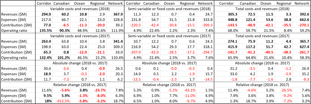
Compiled from: VIA Rail's Summary of the Corporate Plan and Annual Plans 2017 and 2018
Note: figures in bold are provided in above documents, whereas all other figures are derived from these figures.

TY for the detailed response.

Though, clearly absolute subsidy would likely have declined w/cuts to service; I'm not clear if the operating ratio of the Ocean got better or worse after the cut back, which is what I was aiming at.

So the first cut from 7-day service that was in 1990, do you know was the operating ratio was then? Service would be six days a weeks up to 2012 (from 1994), again I wonder did the operating ratio improve materially from spring 2012 to (pre-pandemic) 2020?

****

Relatedly, I know VIA had, at one point, look at a more localized Maritime service connecting the major cities of NB to Halifax.

Given the shorter distance, I don't wonder if the performance of such a route might be superior.

Not in lieu of the Ocean; but where that route is more tourism or perhaps visiting family once a year; the shorter route might have more routine utility for students, patients or perhaps, in some cases, commuters.
 
Last edited:
The above brings to mind a question I've wondere


TY for the detailed response.

Though, clearly absolute subsidy would likely have declined w/cuts to service; I'm not clear if the operating ratio of the Ocean got better or worse after the cut back, which is what I was aiming at.

So the first cut from 7-day service that was in 1990, do you know was the operating ratio was then? Service would be six days a weeks up to 2012 (from 1994), again I wonder did the operating ratio improve materially from spring 2012 to (pre-pandemic) 2020?
I of course have access to that data, but I'm afraid you would have to file an "Access to Information Access". Given that this information was released for the years 2017 and 2018, you might have good chances to obtain the same data for previous years...

Relatedly, I know VIA had, at one point, look at a more localized Maritime service connecting the major cities of NB to Halifax.

Given the shorter distance, I don't wonder if the performance of such a route might be superior.

Not in lieu of the Ocean; but where that route is more tourism or perhaps visiting family once a year; the shorter route might have more routine utility for students, patients or perhaps, in some cases, commuters.
I don't want to dismiss that proposal, but what commercial value (and thus: competitive relevance) would such a once-daily connection have if it still takes the same 5:30 hours to cover the distance between Campbellton and Moncton and 8 hours between Campbellton and Halifax which are currently scheduled for the Ocean, while you can drive this distance of 323 and 564 km, respectively, in 3:30 or 5:50 hours (with the bus taking barely more, if I remember correctly)?
 
I of course have access to that data, but I'm afraid you would have to file an "Access to Information Access". Given that this information was released for the years 2017 and 2018, you might have good chances to obtain the same data for previous years...

I thought the info might have been public in reports at the time of the cuts and simply not available on the website today.

Ah well.

I don't want to dismiss that proposal, but what commercial value (and thus: competitive relevance) would such a once-daily connection have if it still takes the same 5:30 hours to cover the distance between Campbellton and Moncton and 8 hours between Campbellton and Halifax which are currently scheduled for the Ocean, while you can drive this distance of 323 and 564 km, respectively, in 3:30 or 5:50 hours (with the bus taking barely more, if I remember correctly)?

Entirely valid point.

I just looked it up now, and I see Rail Travel time Moncton - HFX in the 4hrs 15m to 4rs 4hrs 30m range. Drive time is listed at 2hrs 43 by Google.

Which, got me to wondering why such a big difference. I have to assume track conditions play some role. But I also noted a bizarre looking bunch of curves. I'm sure there was a logical reason for these going back in time.

But you look at the route the highway follows, and you'd swear the railways planners were in the sauce. LOL Entirely unfair, I'm sure.
 
I thought the info might have been public in reports at the time of the cuts and simply not available on the website today.

Ah well.


Entirely valid point.

I just looked it up now, and I see Rail Travel time Moncton - HFX in the 4hrs 15m to 4rs 4hrs 30m range. Drive time is listed at 2hrs 43 by Google.

Which, got me to wondering why such a big difference. I have to assume track conditions play some role. But I also noted a bizarre looking bunch of curves. I'm sure there was a logical reason for these going back in time.

But you look at the route the highway follows, and you'd swear the railways planners were in the sauce. LOL Entirely unfair, I'm sure.

Drive the route between Moncton and Halifax. You will learn that it is not flat. Those curves you see are the flattest route.
 
Drive the route between Moncton and Halifax. You will learn that it is not flat. Those curves you see are the flattest route.

Indeed! I've been to most of Ontario, and parts of AB, SK, MAN and Quebec; but never to either coast here. (my oversight).

But I popped over to street view to look at the Trans Canada just past Moncton area. There are some serious elevation changes going on!

Which made me think of this thread........by an architect/urban planner I follow on Twitter.

In it, he's comparing how certain challenges of geography tend to get addressed in Europe vs North America by transportation engineers.

Interesting read:

One is cheaper. One is better for the environment.
 
Therefore, I'm not trying to prove that 3:15 can be achieved with little or no alterations to the existing alignment, but to show that claims that such a travel time would be achievable are reasonably credible. This means that I'm making relatively aggressive (but not implausible) assumptions and I will hand over the spreadsheet to you two (and anyone else interested) to play with the various parameters until you believe that the results are reasonably dependable to assume that such a travel time might very well be achievable.

This is a fair point and it emphasizes the differing perspectives we are working from. I will declare a bias, based on past experience stretching all the way back to the unhappy rollout of the Turbo in 1960’s, where initial assumptions around performance of new trains in this country proved unworkable and performance was scaled back over time. I’m also thinking of what the investor’s confidence level may be.

And I am especially worried about what the Ottawa bureaucracy may be trying to achieve by whittling away at the envelope, notwithstanding ROI. My gut says that an $8B HFR would be a winner, but if the bureacracy manages to hold VIA to $5B, will the business case suffer a “death by paper cut”? What can VIA actually do with a skimpy envelope?

The test I am using is undoubtedly more conservative, not because I am trying to naysay, but rather because I am looking for proof closer to “beyond reasonable doubt”.

As I chew through the data curve by curve, it’s very apparent just how much of the value proposition for HFR depends on extracting speed from every short section of this route. It is also apparent that the optimum approach may have to be banking and quick sprints rather than trying to straighten curves, given really rough terrain. So I’m very interested in the sensitivity tests - will HFR really be held to 60 mph on a 3 degree curve (of which there are many)? If that number can be 65, how many minutes are gained? If there is a 60mph curve, how much tangent must there be between it and the next curve to make a “quick sprint” feasible, or will the tangent also acquire a 60 mph limit? Will VIA discover that the “quick sprints” put too much stress on equipment and consume too much brake shoes or fuel, or will crews just find them too onerous and not push to the envelope?

Indeed, these frequent changes in speed limits would be impractical with VIA's current fleet, but with a semi-automated train operation system (see table below) like PTC, it should be possible to have the train adjust the speed to stay within any relevant speed limits at any given time (i.e. forcing the train to break before a more restrictive speed limit takes effect).

Thanks for presenting all that detail! I had a general sense that such systems exist, and what devices they contain, without really understanding how the specifics are applied. Again, the issue for me is what VIA can afford to implement, and will it work as documented without years of tweaking. North American PTC for instance is currently far from credible, although I’m sure it will eventually be made to work acceptably.

This is already really good work, but no worries, I will share my spreadsheet as soon as I have presented it here, so no need to duplicate the efforts...!

Waiting with bated breath! I’m not (just) being bloody-minded in trying to model this myself - although “trust but verify” is the right mentality. It’s actually fun work, in a mind numbing kind of way.... I’m learning a lot about this route, and there are “aha” moments that make it worthwhile.

- Paul
 
As I wrote in my previous post, Brightline in Florida operates with 8 inches of superelevation (5 inches of banking plus 3 inches of cant deficiency) on infrastructure which is still owned and operated by a freight railroad. Also, you should keep in mind that the freight railroad's resistance to increase the cant is less a result of safety concerns as that operating trains over tracks which is banked more than the equilibrium superelevation simply increases the tear and wear on the rails (as the wheels keep grinding at the inside of the lower rail), which suggests that even though freight railroads hate more aggressive superelevations as a RIC (rail infrastructure company), they should be rather indifferent about it on lines where they are merely a ROC (rail operating company) as a tenant...

I was speaking more about VIA acting more as the infrastructure owner in this case. Depending on the number and size of the freight trains, it may be in their best interest to increase the cant deficiency in an effort to reduce the maintenance required to keep the track in good shape.

If the status quo is to remain - an almost daily freight train of 50-ish cars - than absolutely, the amount of superelevation can be increased, and the cant deficiency reduced when compared to what is in effect the current standard on CN. There will be a very small amount of additional maintenance, but nothing that isn't easily managed.

Dan

Reminds me of the grade 7 science fair experiment I did over 30 years ago where I made different angles for the track. There was a point that it would always derail.

Straightening the curves would be better.
 
So they would need to build stations to allow freight trains to pass.

It would allow for freight trains to run at night when VIA is not using the tracks? But a freight derailment would cause serious issues for passengers, so that risk must be taken into consideration.
 
^Nobody is suggesting a track profile that presents risks of derailment. The issues are operating and maintenance cost, and passenger comfort, traded off against HFR trip times.

This would all be moot if the differences in trip time that we are debating had no impact on marketability - ie, ridership, market share, pricing. Some of us believe trip time matters greatly.

Of course, It’s theoretically quite possible that a slower, cheaper to operate HFR might generate more net income than one with more expensive engineering that costs more to operate. But what about that market share ?

That’s a different issue for another day. At this point, all we’re noodling on is what performance envelope VIA can build with the funding envelope it raises..

- Paul
 
Okay, so ready for Part 2 of this "modelling HFR travel times on the existing Havelock alignment" exercise (Refer to post #7,265 for Part 1)?

3. Modelling
3.1 Speed limits


As I've already covered in a previous post, applicable speed limits are mostly determined by the tracks curvature (in combination with the superelevation applied to the curves) and is determined with the following formula:

1599622912667-png.268533

Quoted from: my Master Thesis (p. 60)


The resulting speed limits can be found in the following table:

1599623989911-png.268554

Source: own calculations, first presented in post #7,260


In terms of the curves, I reviewed my .kmz file (here the newest version) and found another 10 curves (of which 2 have a radius of less than 550 meters), for a total of now 280 curves (or one every 1.4 km):

1601259398173.png

Source: own calculations with track geometry data estimated by using the circle drawing function built into Google Earth Pro

As you can see in above table, a superelevation of 5 inches only allows HFR trains to keep their top speed (assumed at 110 mph) in curves of the highest category (i.e. a radius of 3000 meters), which means that more than 90% of all curves require the train to slow down and that means in the case of just under 80% of all curves to slow down below 76.4 mph (i.e. the average speed which is required to achieve a travel time of exactly 3:15 hours between Ottawa and Toronto). Conversely, with a superelevation of 10 inches, HFR trains could also keep their top speed in curves with a radius of 2400 or 1700 meters and would only have to slow down in just under 80% of all curves and below the 76.4 mph in only just over 40% of all curves.


3.2 Uniform acceleration

Without access to specialist software (one of the main limitations of my Master Thesis!), the only realistic way to calculate travel times is to assume uniform acceleration, i.e. by distinguishing between three different types of movement: acceleration (where the train speed increases by exactly the acceleration value), constant movement (where the speed is unchanged) and breaking (where the train speed decreases by exactly the deceleration value). The main advantage is that the acceleration and breaking behavior is reduced to only two variables, which can be applied in the following two textbook formulae:
1601257934399.png

Quoted from: my Master Thesis (p. 77)

Despite ignoring factors like gradients, this still get's quite complicated, but anyone really interested in this can read about it in Chapter 6 of you-know-what...


3.3 Fixed blocks vs. variable block

An important point in my Thesis was to compare the effects of fixed vs. variable blocks on achievable train frequency, as train capacity was an important consideration. If you recall what I just explained to Paul about PZB vs. LZB, variable blocks are basically a system with stationary signals (which in Germany would be protected with PZB magnets) and a system without signals, where moving authority and speed limits are communicated directly to the train (which in Germany would be the responsibility of LZB). For our purposes, however, we are more concerned about static speed limits (i.e. those permanently imposed to reflect track curvature than those temporarily imposed by signals) than about how long a train remains in a block, and therefore, it would be more accurate to talk about whether we assume speed limits which apply to individual curves or zones (which combine multiple curves, like Paul suggested).

Given that VIA's future fleet is based on the Siemens Charger locomotives, which run for Amtrak and (when it resumes service again) Brightline with mandated PTC, which requires a continuous and proactive enforcement of speed-limits (i.e. like LZB and unlike PZB), I believe it is reasonable to assume that the block lengths for speed limits would be fixed rather than variable, which means that I calculate speed limits with a granularity of 80 meters (i.e. 20 blocks per mile) rather than variable blocks with lengths of anything between 100 meters and multiple kilometers, which means that applicable speed limits may change a dozen time within a minute of a train's runtime, which would be far beyond what a human driver could process and safely reflect in his choice of acceleration and deceleration commands to the train's traction motors and breaks...


***

Having laid out the fundamentals of modelling train runtimes, I will show how to implement and solve the model to estimate the travel times for the existing Havelock alignment:


4. Model Solving

  1. Ignoring s-curves
  2. Respecting s-curves

In the meanwhile, please let me know if I lost you somewhere...
 
Last edited:
Why are we discussing freight? The whole idea of HFR is that these will be dedicated passenger tracks without freight on them.

There is still freight service between Agincourt and Havelock. It is much less frequent than what VIA deals with on the CN line. I assume it can remain if the timing is adjusted. cc @crs1026
 
Another report on the continuing saga of HFR and the Trudeau government's timelines for a decision.


The suggestion is that a decision is hoped for in time for a spring budget.

So another 5-6 months yet.

The article also reports on concerns with blockades of rail and an apparent increase in tampering w/rail, including signal systems.
 
Last edited:

Back
Top