News   Mar 28, 2024
 525     0 
News   Mar 28, 2024
 410     1 
News   Mar 28, 2024
 749     0 

VIA Rail

How many campers would actually use the train to camp? I once worked with a guy who said their are 3 types of campers:
  1. The majority want to be able to drive to the campsite with a vehicle full of all the stuff they "need"
  2. Some will canoe to their campsite, to to get away from the crowds, but it means you need to be able to fit everything you need in the canoe,
  3. He would portage his canoe (I seem to remember him saying he did it twice) to find a site so remote that they wouldn't see anyone else all week. That means you need to be able to carry everything you need, including your canoe.
A train would only work for the second and third type of campers. On top of that, Hwy 60 passes right through the park and most of the campsites are off of the highway.


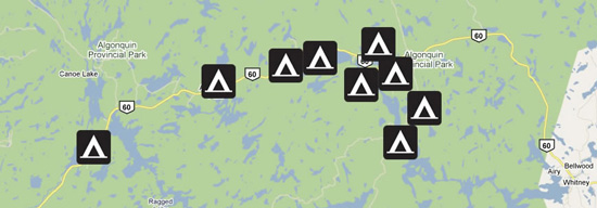
Developed Campgrounds - Highway 60


I think you are talking about the old OAPS line, which traveled through the southern end of the park and was split east and west of the park in 1933 when CN decided that the trestle over Cache Lake wasn't worth repairing. I'm guessing it became Hwy-60 through the park, though I might be mistaken on that one.

There was also the old Canadian Northern line which traveled through the middle of the park and was abandoned in the late 90's. The latter ROW passes through the Achray, Brent and Kiosk Campgrounds, and would make a nice tourist train route that could double as access for campers. The only thing is the park was eager to get the trains out of the park as they made a lot of noise, so it could be a challenge to start up again.

At the risk of continuing this off-topic bounce, I'm not aware of any of Hwy 60 follows the old OAPS line. The ROW ran south of it then crosses the highway roughly around Cache Lake then runs north of it, exiting the park near Kearney.
 
I've been getting impatient about the slow progress on the US Customs pre-clearance facility at Montréal Gare Centrale, so I fell down a rabbit hole reading up on that station.

It turns out that REM will be using tracks 09 and 12, with a wide island platform between them. Unfortunately, this cuts nearly half the station off from mainline trains. The remaining tracks to the south will only be used for storing REM trains. While this setup was certainly the path of least resistance given that those were the platforms the Deux-Montagnes and Mascouche trains used to use, I think it would have been more foresightful to use tracks 07 and 10 instead. Platforms 09/10 and 11/12 are the only two platforms with multiple vertical access points along their length, and given that REM platforms are only 80 metres long, they aren't even making use of all of them. It is a silly situation to have full 8-car bilevel trains coming in from Mont-Saint-Hilaire and funneling all the passengers through the single staircase into the great hall.

Vertical Circulation highlighted in red
View attachment 294015
Platform 07/08 apparently had its staircase removed at some point, leaving it unusable for revenue service, but REM could have made use of its space since its platform would include the existing accesses to platform 09/10.

Where do those other "vertical access points" come out in the great hall? I don't ever remember seeing them.

As you said, platform 07/08 had its staircase removed to create more retail space (I beleive Bureau en Gros, aka Staples, occupied it last time I was in Montreal), so using it would require convincing the owner of the station, Cominar REIT, to evict a one of its tenants. Also, if you look at this track diagram (not to scale) tracks 4-12 are completely isolated from tracks 13-23 until they merge at switch 195. I beleive the plan is to break that merge and run new set of parallel tracks out of the station for the REM. Reconfiguring the tree to allow VIA access to tracks 11 & 12 would require more work. You can actually see the construction for the new bridge across the Peel Basin in Google Maps (also below).

Regardless, this change will help VIA a bit, since they will have fewer trains to compete with when approaching the station.

MontrealCentralStationTrackPlan.gif


New Montreal Bridge.png

Anyway, the obvious place for a future US customs-sealed platform would be platform 23, which used to be a private platform for CN executives. It has never been used in revenue service since it doesn't connect directly to the great hall, but its isolation actually makes it perfect for a customs-controlled area. Locating Amtrak there also avoids the need to take any space away from VIA and the RTM.
View attachment 294016
According to this floorplan (which seems to be from the 60's or 70's), there seems to be an open area adjacent to the platform with a staircase, but I don't see where the staircase comes out on the upstairs floorplan. To access that area from the main level, whichever shop is above that spot may need to be acquired.

To improve air quality in the trainshed, I wonder if it would be practical to electrify the Amtrak track with the same 750V DC third rail system that the trains already use in Penn Station at the other end of their route. That would allow the diesel engines to be off while sitting (quite deep in the trainshed) without the hassle of running the usual HEP cables.

On an unrelated note, the map suggests that there are some exits from the north end of the terminating platforms. I wonder what the state of those accesses is today.

One comment about your second map. I believe platform 21/22 is reserved for EXO's Mont-Saint-Hilaire and Mascouche lines, and VIA will use tracks 13-20.
 
Last edited:
How many campers would actually use the train to camp? I once worked with a guy who said their are 3 types of campers:
  1. The majority want to be able to drive to the campsite with a vehicle full of all the stuff they "need"
  2. Some will canoe to their campsite, to to get away from the crowds, but it means you need to be able to fit everything you need in the canoe,
  3. He would portage his canoe (I seem to remember him saying he did it twice) to find a site so remote that they wouldn't see anyone else all week. That means you need to be able to carry everything you need, including your canoe.
A train would only work for the second and third type of campers. On top of that, Hwy 60 passes right through the park and most of the campsites are off of the highway.


Developed Campgrounds - Highway 60


I think you are talking about the old OAPS line, which traveled through the southern end of the park and was split east and west of the park in 1933 when CN decided that the trestle over Cache Lake wasn't worth repairing. I'm guessing it became Hwy-60 through the park, though I might be mistaken on that one.

There was also the old Canadian Northern line which traveled through the middle of the park and was abandoned in the late 90's. The latter ROW passes through the Achray, Brent and Kiosk Campgrounds, and would make a nice tourist train route that could double as access for campers. The only thing is the park was eager to get the trains out of the park as they made a lot of noise, so it could be a challenge to start up again.

What about those that wish to camp at the regular campgrounds, but do not have a vehicle?

At the risk of continuing this off-topic bounce, I'm not aware of any of Hwy 60 follows the old OAPS line. The ROW ran south of it then crosses the highway roughly around Cache Lake then runs north of it, exiting the park near Kearney.

An old ROW does run near the Mew Lake and Rock Lake Campgrounds.
 
Does anybody know when we should know when HFR will either be officially approved or cancelled? Like a timeframe or date. I remember seeing something about this spring?

Again, with the strong potential of an election this year along with the uncertainty of a minority government, I sadly don't think HFR has a future.
 
What about those that wish to camp at the regular campgrounds, but do not have a vehicle?

The original post was:

All of that Algonquin traffic comes into the park by car. Wouldn't it be nice if there were a local rail service across the park so people could leave their cars at the park gate?

If they didn't have a vehicle, how would they get to the to the park gate?
 
I struggle to see why the below needs to be discussed in this thread. Please continue this discussion in the General Railway Discussions thread or if it’s not interesting enough for that thread, it certainly isn’t for this thread...

Thank you!
What about those that wish to camp at the regular campgrounds, but do not have a vehicle?


An old ROW does run near the Mew Lake and Rock Lake Campgrounds.
Ah, Well, I guess I look at it as why park at the gate? Why not drive the rest of the way.
 
An old ROW does run near the Mew Lake and Rock Lake Campgrounds.
Cool, but that wasn't the statement I was responding to.

I think you are talking about the old OAPS line, which traveled through the southern end of the park and was split east and west of the park in 1933 when CN decided that the trestle over Cache Lake wasn't worth repairing. I'm guessing it became Hwy-60 through the park, though I might be mistaken on that one.

I imagine the old ROW runs near a number of places.
 
Does anybody know when we should know when HFR will either be officially approved or cancelled? Like a timeframe or date. I remember seeing something about this spring?

Again, with the strong potential of an election this year along with the uncertainty of a minority government, I sadly don't think HFR has a future.

I suspect the timing is off. Right now all the media is concerned about domestically is battling COVID. In the spring they will be interested in fiscal recovery efforts and HFR will provide a lot of Canadian jobs not only in construction but engineering and in the steel industry, so it ticks several boxes.

I think even the Conservatives might support HFR. Once when Pierre Poilievre came door knocking a few years ago, I ask him about HFR and although he surprisingly hadn’t heard of it, he did say, unprompted, that he would be interested in projects that would reduce VIA’s need for subsidies. 🤨 I know that’s just one MP’s option, but he is quite high up in the ranks
 
I think even the Conservatives might support HFR. Once when Pierre Poilievre came door knocking a few years ago, I ask him about HFR and although he surprisingly hadn’t heard of it, he did say, unprompted, that he would be interested in projects that would reduce VIA’s need for subsidies. 🤨

That does bring up an interesting question actually; would HFR be cheaper operationally than paying CN to use their corridor.

On one hand you aren't paying CN or CP to use their stuff, and we know that lots of times they have been caught overcharging VIA, but on the other hand maintaining your own rail lines is not cheap.
 
Where do those other "vertical access points" come out in the great hall? I don't ever remember seeing them.

Platforms 09/10 and 11/12 have a second set of stairs just north (left) of the great hall flanking the Second Cup, according to this pretty recent floorplan which I have marked up in red.
I had to turn this diagram upside down because it was the other way up from the CN track-level plan I posted previously. The red text on some of the staircases says "up" not "dn".
VIA_GareCentrale-plan-labeled.jpg


The stairs further down the platform are a bit more curious. According to the 50-year-old track-level plan, tracks 09/10 and 11/12 should have stairs on either side of Rue de la Gauchetière, and plaform 07/08 should have one staircase on the north side only. The present-day ground-level plan only shows the stairs from the abandoned platform 07/08, which are apparently accessed from one or more of these unmarked doors on Rue de la Gauchetière.
Capture2.JPG


The stairs from 09/10 and 11/12 are nowhere to be seen on the ground floor plan, but there is a suspiciously staircase-sized unit marked in the parking garage right over platform 11/12. Sure enough, looking through the glass doors via Streetview you can see a railing heading down.
Capture.JPG

But the numerous "Entrée Interdite" signs make it pretty clear that this staircase is no longer in public use.

I don't see any traces of the stairs from platform 09/10. If someone's in the area, they could try running at the wall between tracks 09 and 10 to see if they pass through, but barring that I think we can assume that they've been demolished.

I have no idea what the fate is of the staircases on the south side of Rue de la Gauchetière, because the floorplan doesn't extend that far and I don't see any clues via Streetview.

As you said, platform 07/08 had its staircase removed to create more retail space (I beleive Bureau en Gros, aka Staples, occupied it last time I was in Montreal), so using it would require convincing the owner of the station, Cominar REIT, to evict a one of its tenants.

I have marked the position of the former staircase on the plan above by extrapolating the dimensions of the other staircases. The location of the row of pillars (in the centre of the platform) confirms that this is the right position.

The staircase itself doesn't actually encroach on the Bureau en Gros, but the store would need to be cut back to allow people to access the staircase. Evicting them would be unnecessary.

But in any case, I never said that we would reinstate that staircase. In the concept I described, there would be a large platform between tracks 07 and 10, so people could access track 07 from the current platform 09/10 staircases and elevators.

Also, if you look at this track diagram (not to scale) tracks 4-12 are completely isolated from tracks 13-23 until they merge at switch 195. I beleive the plan is to break that merge and run new set of parallel tracks out of the station for the REM. Reconfiguring the tree to allow VIA access to tracks 11 & 12 would require more work. You can actually see the construction for the new bridge across the Peel Basin in Google Maps (also below).

Yes, like I said, it is clearly much easier to use 09-12 for REM, since it maintains pretty much the existing track configuration, with a pair of tracks each for the Montreal Subdivision and Deux-Montagnes Subdivision (now REM).

But my concern is that once the megaplatform is built between 09 and 12, it will be quite a challenge to relocate in the future if we ever want to run additional train service into Gare Centrale. 10 tracks may sound like a lot, but terminal stations have a notoriously low capacity per platform due to the long dwell times and conflicts in the rail corridor.

Regardless, this change will help VIA a bit, since they will have fewer trains to compete with when approaching the station.

The only trains that REM is directly replacing are the Mascouche and Deux-Montagnes trains which never conflicted with VIA in the first place since they exited from the north side of the station. VIA's own Jonquière and Senneterre trains could theoretically get cut back to Côte-des-Neiges REM station and not serve Gare Centrale, given that transferring to the REM would be considerably faster than the huge detour VIA trains need to take. But I'm guessing the trains themselves need to be downtown anyway to go back to the yard, so they'll continue serving Gare Centrale.

One comment about your second map. I believe platform 21/22 is reserved for EXO's Mont-Saint-Hilaire and Mascouche lines, and VIA will use tracks 13-20.

I was wondering about that. 21/22 does make sense for Exo considering all their trains will be heading to/from the east once the REM opens (the Mascouche line will be cut back to Côte-de-Liesse station). There is also another staircase on that platform into the great hall that I had missed when I marked up the first map in my previous post.
 
Last edited:
HFR from Toronto would come in from the South (right side), so they won't need to use the REM tracks. If they figure out how to get HFR from Quebec to Montreal through the tunnel, they would share tracks with REM, but that seems very unlikely at this point.
Agreed, I can't wait for JPO results. I'm giddy. Don't disappoint me!!

Thanks!

Does anybody know when we should know when HFR will either be officially approved or cancelled? Like a timeframe or date. I remember seeing something about this spring?

Again, with the strong potential of an election this year along with the uncertainty of a minority government, I sadly don't think HFR has a future.

As far as I know, this is the most recent public update/public comments.

Post in thread 'VIA Rail' https://urbantoronto.ca/forum/threads/via-rail.21060/post-1621928

I also haven't seen any media articles since this.
 
There is supposed to be a budget released in the spring, with the potential of an election being called over it.
If it is in the budget, and the budget passes a confidence motion, then it will happen sooner than later.
If it is not in the budget, it is pushed further down the line.
If it is in the Budget, but the budget is defeated, and we go to an election, then it also will get pushed down the line. Watch for which platform has it and which does not, and who wins the election.

HFR is almost a fantasy at this point. Yes, there are plans, but nothing has been awarded.
 

Back
Top