News   Jul 12, 2024
 1.3K     0 
News   Jul 12, 2024
 1.1K     1 
News   Jul 12, 2024
 391     0 

Urban Wilderness!

Silver Creek - twin creeks: flurry walk with me, pt. 1

Inclement weather and a sore foot kept me off the trails last week, so I figured it was time for another double-header this time around. Off to Etobicoke then, to tackle a pair of creeks which sprout northwest from the Humber River on either side of Eglinton Avenue, beginning with Silver Creek - the one south of Eglinton - which meets the Humber on the border between James Gardens and Scarlett Mills Park:

85590384.jpg
85590387.jpg


85590392.jpg
85590393.jpg


85590399.jpg
85590409.jpg


85590403.jpg


Quickly through Edenbridge Drive and I'm out into the (mostly) unclaimed strip of land between Valecrest and North Drive:

85590415.jpg
85590421.jpg


85590423.jpg
85590419.jpg


85590426.jpg
85590428.jpg


85590431.jpg
85590434.jpg


85590436.jpg
85590438.jpg


85590440.jpg
85590448.jpg


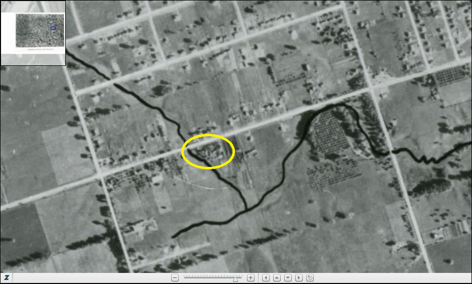
Right before heading under Royal York Road I once again spot a deer, off in the distance on the other side of the creek. Having failed to capture a pic the last couple of times I've come across one, I thought I'd give my camera's primitive zoom function a try and see what I could get. Well, perhaps it's best I didn't get a nice tight shot here, as the deer was rather lustily evacuating itself at the time:

85590452.jpg
85590456.jpg


85590459.jpg
85590460.jpg


85590461.jpg
85590462.jpg


A brief trek through the brief Edenbrook Park:

85590465.jpg
85590470.jpg


85590472.jpg
85590476.jpg


85590479.jpg
85590481.jpg


85590483.jpg
85590491.jpg


85590492.jpg


Over the bridge now and into St. George's Country Club where the creek ends not in Silver Creek Park (where you'd expect it once did), but just south of Eglinton, by which I traverse back to my next creek:

85590494.jpg
85590497.jpg


85590500.jpg
85590502.jpg


85590505.jpg
85590508.jpg


85590512.jpg
85590515.jpg
 
Humber Creek - twin creeks: flurry walk with me, pt. 2

The second creek of the day seems to go (or have gone by) a number of different names - Chapman Creek, Sturgeon Creek, and the Little Humber being three of them that I could find. The most prevalent, however, seems to be Humber Creek, so that's what I'll go by here. Whatever you may choose to call it though, as it turns out, I actually already covered a short portion of it running from Scarlett Road to the Humber River on a previous journey; so let's not waste any time in coming through the other side of Scarlett and into Chapman Valley Park:

85591654.jpg
85591663.jpg


85591668.jpg
85591671.jpg


85591673.jpg
85591678.jpg


85591680.jpg
85591682.jpg


85591684.jpg
85591686.jpg


85591689.jpg
85591692.jpg


85591696.jpg
85591701.jpg


85591704.jpg
85591706.jpg


Somewhere along the way - let's say here - Chapman Valley Park becomes Weston Wood Park:

85591709.jpg
85591714.jpg


85591718.jpg
85591725.jpg


85591721.jpg
85591730.jpg


85591733.jpg
85591737.jpg


Under three streets in quick succession now - Brittany Court, Royal York Road, and The Westway:

85591740.jpg
85591743.jpg


85591745.jpg
85591748.jpg


85591752.jpg
85591754.jpg


85591755.jpg
85591758.jpg


85591765.jpg
85591768.jpg


85591772.jpg
85591777.jpg


85591775.jpg
85591783.jpg


85591787.jpg


Past Sanctuary Cemetery and into Alex Marchetti Park, with its own series of three bridges:

85591790.jpg
85591799.jpg


85591802.jpg
85591806.jpg


85591811.jpg
85591816.jpg


85591822.jpg
85591828.jpg


85591832.jpg
85591839.jpg


The bridge-ness business continues under Islington Avenue:

85591843.jpg
85591846.jpg


85591849.jpg
85591852.jpg


85591858.jpg
85591862.jpg


Past Islington the creek takes an upturn as it bends around the Briarcrest Manor apartment complex:

85591867.jpg
85591875.jpg


85591871.jpg
85591877.jpg


85591882.jpg
85591885.jpg


85591890.jpg
85591903.jpg


Under we go again - though not beneath a street this time - but under the apartment complex itself:

85591898.jpg
85591905.jpg


85591907.jpg
85591912.jpg


85591916.jpg
85591919.jpg


Out into Wincott Park, where the Humber Creek produces a pond...:

85591922.jpg
85591926.jpg


85591931.jpg
85591933.jpg


85591936.jpg
85591946.jpg


85591942.jpg


...then continues on toward Wincott Drive:

85591951.jpg
85591956.jpg


85591961.jpg
85591967.jpg


85591969.jpg
85591974.jpg


85591977.jpg


One last, little push through Wincott before terminating just shy of Dixon Road:

85591979.jpg
85591980.jpg


85591983.jpg
85591985.jpg


85591995.jpg
85591989.jpg


85591991.jpg
85592000.jpg


85591996.jpg
85592004.jpg


85592006.jpg
85592010.jpg


85592012.jpg
 
fascinating stories, evcco, i especially liked the "rather lustily" description...

the last creek, where you ended your journey, is where i lived in 1954 --

dixon-road-1954.jpg

dixon-road-today.jpg


the creek was barely a yard across, but it did have little fishies in it, i remember trying to catch one with a piece of bread on a safety pin on a string! (i was only 5 at the time)

the aerial photo is from http://library.mcmaster.ca/maps/airphotos/zoom/1954-1955_436793.htm and apparently someone traced the course of the creeks onto the maps -- you can see that the creek continued north, across dixon road, kipling, the 401, and almost to martin grove at the GO tracks

there are many more of these photos of southern Ontario at http://library.mcmaster.ca/maps/airphotos/1954_55.htm
 
Well, how about that!

Talk about an area changing in your lifetime...
Dixon is pretty much a concrete jungle at this point. It's hard to imagine it as a place for farms and cottages today.
I take it you also didn't have jumbo jets flying over head every 5 minutes to Pearson. Was there much traffic to Malton Airport at the time?

Also, did the creek go by any of the names I mentioned back then that you can recall, or was it just simply "the creek"?
 
I take it you also didn't have jumbo jets flying over head every 5 minutes to Pearson. Was there much traffic to Malton Airport at the time?
i don't recall airplane traffic there at all, and of course as a 5-year-old i wasn't aware of any creek names

a few years later (1957-1961) we lived near martin grove and richview side road (now eglinton) and i do recall the avro arrow flying over a couple times...
 
German Mills Creek - double double, pt. 1

It's a day after the great snowfall of '13 and, for the second week in a row, I'm out to tackle 2 streams at once - going for that rare double double. This time up in North York, along the German Mills and Duncan Woods creeks.

As some of you may remember, the last time that I followed the East Don River I took a wrong turn down the German Mills Creek, ending up somewhere in Bestview Park before realizing my mistake. Yesterday, just as I turned past the Tim Horton's in Finch subway station on my way to the bus, the thought occurred that perhaps this trip itself might be another mistake. I mean, what do all those park signs usually say about "No Winter Maintenance?" Might I be more in for double trouble, than a double double - fighting my way through waist deep snow drifts, lost (even snowblind!) with no path to follow through the frozen wastes...only to end up buried in an avalanche under some forgotten overpass?

Well, luckily, when I arrived at the East Don Parkland I was pleased to find that some intrepid early-morning skiers had already cleared a trail almost all the way through. Nevertheless, it was still pretty slow going, with snow up to my knees much of the way, as these pics will attest to:

85859847.jpg
85859851.jpg


85859855.jpg
85859860.jpg


85859864.jpg
85859868.jpg


85859874.jpg


On beyond Bestway at last, through the Pinewood-Goldenwood pedestrian bridge:

85859878.jpg
85859881.jpg


85859884.jpg
85859891.jpg


85859896.jpg
85859905.jpg


A theme begins to develop by the CN rail bridge:

85859923.jpg
85859920.jpg


85859928.jpg
85859932.jpg


85859939.jpg
85859936.jpg


85859954.jpg
85859960.jpg


Continuing east, towards Leslie Street:

85859964.jpg
85859967.jpg


85859974.jpg
85859982.jpg


85859990.jpg
85859992.jpg


85859993.jpg
85859997.jpg


85859999.jpg
85860001.jpg


A last little bit before Steeles Ave, and the final part of this half of the trek:

85860003.jpg
85860009.jpg


85860013.jpg
85860017.jpg


85860027.jpg
85860029.jpg


85860036.jpg
85860041.jpg


85860033.jpg
85860047.jpg


85860045.jpg
85859837.jpg
 
Duncan Woods Creek - double double, pt. 2

So much for the sugar, now for the cream... I should probably point out that while crossing back over Steeles (to where the Duncan meets the German just to the south, in the Steeles-Leslie Greenbelt) I dinged my knee rather badly on a metal road barrier hidden in a snowbank. So now, in addition to all this snow, I also had a bit of a limp to deal with. From here on out, then, it was pretty much a matter of getting through everything as quickly and painlessly as possible, which is why I didn't take very many pictures here. To be honest, though, there isn't really a lot to take pictures of along the Duncan Woods Creek. That is, I didn't see much of interest. Of course, it could all very well just have been buried:

85860543.jpg
85860546.jpg


85860549.jpg
85860553.jpg


85860557.jpg
85860559.jpg


Further south, through Duncan Creek Park:

85860560.jpg
85860562.jpg


85860565.jpg
85860569.jpg


85860579.jpg
85860583.jpg


Trailing the coffee-coloured creek into Zircon Park:

85860586.jpg
85860589.jpg


85860592.jpg
85860595.jpg


85860598.jpg
85860602.jpg


A few finishing shots at the creek's terminus in Wellesbourne Park:

85860604.jpg
85860607.jpg


85860608.jpg
85860611.jpg


At the end of the day, then, what would have usually been about a 2 hour trek (at most) ending up taking twice as long thanks to all the snow.
Now, I'm not much of a coffee drinker myself - but after a hike like that I could certainly use a nice, warm beverage...if not two.
 
Last edited:
Centennial Creek - off-putting

This is another of those creeks which I've been putting off. I had always assumed, from viewing maps of the area, that covering this creek would be a bit of a nuisance. For one thing, it runs nearly its entire course through people's backyards, which, obviously, is problematic. For another, it ends its course in the vast Stevenson Swamp - an almost impenetrable marshland at the bottom of Highland Creek - which I wouldn't even attempt to access in the warmer months. Nevertheless, we can't put these things off forever. So I finally stop my procrastination, and begin this week's trek at the creek's initial outfall near Meadowvale and White Ave. Right off the bat I encounter a pond here - which I usually only tend to find near the end of my hikes. Hopefully, then, I'm not going the wrong way!:

86200604.jpg
86200608.jpg


86200606.jpg
86200612.jpg


86200617.jpg
86200619.jpg


86200620.jpg
86200623.jpg


Through Kingston Road and Highway 2a:

86200625.jpg
86200628.jpg


86200630.jpg
86200633.jpg


86200637.jpg
86200639.jpg


86200641.jpg
86200643.jpg


86200647.jpg
86200649.jpg


86200651.jpg
86200656.jpg


Pressing south to Lawson Road:

86200660.jpg
86200664.jpg


86200667.jpg
86200670.jpg


86200672.jpg
86200674.jpg


86200676.jpg
86200679.jpg


Further out into the backyards of the Centennial neighbourhood. I must say, I've never seen quite so many private bridges, from one property to another, across one creek. These folks must be mighty neighbourly. Along the way, in fact, one folk was neighbourly enough to point out where exactly his property was, and which side of the fence to stay on. Another woman yelled something I couldn't quite make-out, though I assume it was some friendly greeting or salutation of the neighbourly sort. Other than that, however, I didn't run across too many folks out here:

86200681.jpg
86200683.jpg


86200686.jpg
86200688.jpg


86200691.jpg
86200696.jpg


86200698.jpg
86200701.jpg


86200703.jpg
86200704.jpg


Briefly out of the backyards now, and behind St. Brendan Catholic School:

86200707.jpg
86200710.jpg


86200711.jpg
86200712.jpg


86200716.jpg
86200720.jpg


Another frozen underpass, through Clemes Drive. With the stalactite-like icicles, and primitive graffiti, one can almost imagine they're exploring the famous caves of Lascaux under here. Well...maybe not. Back, then, to the backyards - and more bridges than ever!:

86200721.jpg
86200722.jpg


86200723.jpg
86200726.jpg


86200727.jpg
86200729.jpg


86200731.jpg
86200735.jpg


86200739.jpg
86200740.jpg


86200742.jpg
86200744.jpg


86200749.jpg
86200751.jpg


86200756.jpg
86200753.jpg


Under Lawrence Ave, now, where I'm in for a suprise!:

86200757.jpg
86200761.jpg


86200762.jpg
86200763.jpg


86200766.jpg


The creek branches back north right under the road:

86200767.jpg
86200768.jpg


86200769.jpg
86200770.jpg


86200772.jpg
86200771.jpg


Back above ground I follow this new stream to its quick demise at Bathgate Drive:

86200774.jpg
86200777.jpg


86200779.jpg
86200780.jpg


86200783.jpg
86200784.jpg


86200785.jpg
86200787.jpg


86200789.jpg
86200792.jpg


Returning to Lawrence Ave I make a sports-themed final push through the private properties:

86200793.jpg
86200794.jpg


86200797.jpg
86200798.jpg


86200803.jpg
86200809.jpg


86200812.jpg
86200816.jpg


86200818.jpg
86200823.jpg


86200826.jpg


Into the great wide open of the Stevenson Swamp, to end at the Highland Creek:

86200829.jpg
86200832.jpg


86200836.jpg
86200839.jpg


86200843.jpg
86200845.jpg


86200847.jpg
86200851.jpg


86200860.jpg
86200862.jpg


86200865.jpg
 
I enjoyed your jorneys as usual EVCco. Do you have a preference for when you go out? Winter, summer? I have to admit that we haven't been motivated to head out since the white stuff hit. Something about the smell of the grass and the trees that make us inspired.
 
Each season definitely has its own charms. If you're interested mostly in checking out the flora & fauna, spring and summer are obviously better. But if you're just into exploring, I actually prefer winter. You can see a lot farther, and get into more off-the-beaten-path-type spots without all the foliage around. And, of course, there's no bugs to bite you every 5 seconds! Also, as much as I love the smell of grass and trees myself, on a hot, muggy, summer's day there's some pretty funky smells out there too - especially by the water...
 

Back
Top