News   Jul 09, 2024
 656     0 
News   Jul 09, 2024
 358     0 
News   Jul 09, 2024
 461     0 

Transit Fantasy Maps

- DRL - obviously good idea (and should be the next major capital project, before any Sheppard, Yonge or B-D extensions). Exact routing can still be quibbled (and as you mentioned with Union, this will depend hugely on construction logistical issues, not just where people think it would make a pretty line on a map).

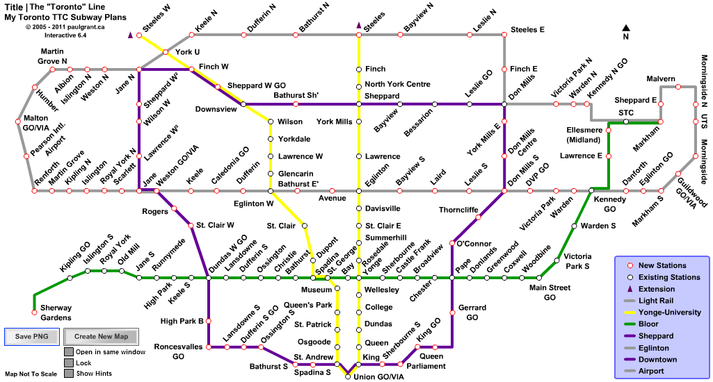
So I see that we do agree on something. The only reason the Sheppard West extension is even on the map is that I felt bad for the corridor because it has so many transfers. It is very low priority on the map. DRL is obviously the highest priority (phase 1 is between Exhibition and Pape), but Eglinton would most likely get built first because the plans are already underway.

- I don't agree with the idea of making the currently planned Eglinton LRT a full-fledged HRT subway (it definitely needs to be underground though in the central portion).

I put the Eglinton West line as a subway because it wouldn't cost that much more than the LRT. The central portion would cost the same as the LRT, so the only issue is west of Jane. If it as a subway, in addition to increasing speed and reliability, it would massively increase land values along the Richview corridor, where the City owns a reasonable amount of property. That could also help offset the cost of building a cut and cover subway under Eglinton.

- Beyond that, why not get some more TC-style lines to make it a true network and not just isolated lines?

I was trying to make a network, so I put all TC lines on the map except Eglinton West and Don Mills South, as both were replaced by subways. Scarborough-Malvern LRT is missing, because I don't really see the demand for it. I guess I forgot Jane, but I think there are space issues on the southern portion. I probably could add it from Steeles to Eglinton though.
 
I haven't posted my map in a while, here it is again with a few updates,

My_TTC_Subway_Plans_Toronto_Line.png


Technically this design is just expansions of existing subway lines, no new lines ;) also with this design, only 1 new light rail line :cool:.
 
Excellent looking map. Looks like you put it quite a bit of work on it. Why don't you submit to the city. But it won't happen unless Toronto tries to encourage more business/corporation centres away from the financial district/downtown north york. Also the way the canadian gov't encourages new immigrants to live in other less populated cities in Canada , your map will probably not happen any decades soon. Maybe by 2050?
 
I think that if we ever see this sort of thing in our lifetimes then the 905 (particularly Mississauga) will have to be included. Suburban Toronto and suburban Mississauga aren't really as different as you might think. If densities get high enough 50 years from now to justify a Sheppard line and an Eglinton line running the full length of northern Toronto, then we can probably justify a subway or two to Mississauga Centre and a subway along Hurontario St.

(Note I do not live in Mississauga, but the blank spot on the western edge of the map is annoying. The population density of Mississauga is 2nd only to Toronto in the GTA and growing rapidly.)

Agreed, a subway connecting to Markham Centre either via an extended DRL or a Highway 7 subway could be justified too, maybe even one to Bramalea/Brampton.

Mississauga's density is only 5-25% lower than Etobicoke, North York and Scarborough, and I suspect having Pearson Airport and the huge employment lands surrounding it are the main reason it's lower. While Markham, Vaughan, Brampton and Richmond Hill are currently not as dense as Mississauga, I suspect the gap will be reduced in the future.
 
For maximum density, a subway extension into Mississauga would have to be along Dundas only, as depicted on my map. This is probably preferable to building a short Dundas LRT between Hurontario and Islington.

A subway to MCC would be too long and the density is not there for the routing. Higher cost and lower density is not a good combination. Plus, a direct subway connection to MCC is kind of pointless considering the Bloor-Danforth line does not serve the Financial District. A commuter rail line would better than subway, maybe a branch of the Georgetown Line if the Mississauga (and 407) Transitway is converted to rail.

Markham Centre would definitely not be good for a subway extension. South Markham and north Scarborough doesn't have enough density of development potential. Plus, the Stouffeville Line already passes through Markham Centre.

Which page is your map on?

Anyways, why would the subway have to be along Dundas? Couldn't it work along Bloor too, which would direct the line straight into MCC? Bloor street goes closer to a lot of the highrises in Eastern Missississauga and West Etobicoke. The main advantage of Dundas would be that redeveloping the land around subway stations would be less controversial since it's employment lands and not residential neighbourhoods. A smaller advantage is that it's slightly closer to the GO station. However, MCC has a shopping mall, major transit terminal + 403 transitway (I suspect you meant 403, not 407?) and a greater employment and greater residential population. Also, I don't think an extension of the Georgetown line to MCC would make much sense. It would be a huge detour for people going downtown Toronto and there isn't really anywhere along the way that someone from Mississauga would want to go to. If anything, it would rather take people into Mississauga. I suppose improving the Milton line and access to Cooksville GO station from MCC could make a subway unnessary though.

As for Markham, the alignment I was thinking of was along Don Mills and then either

a)head towards Warden and Finch where there is a large tower in the park neighbourhood and continue along Warden where there would be another tower in the park neighbourhood, and then some employment lands that I think Markham planned on redeveloping. It would also come within 1-2km of the Asian mall redevelopments.
b) continue along Don Mills, grabbing riders from the residential high rises there with a stop in Seneca College. Then hit up a couple office parks along Woodbine
i)continue along Woodbine until Highway 7 where there is a large office park
ii) curve Westward towards Markham Centre

As for the Stouffville line, it's mostly designed for bringing people from Markham into downtown Toronto. This subway line would have a more diverse user base and be more bi-directional with riders heading to the office parks and retail in Markham and NE North York.
or continue along Don Mills up to Finch
 
Maybe doady meant rerouting the Milton line to MCC, which I actually agree with, provided it doesn't affect the locations of either Cooksville or Erindale greatly.
 
If any rapid transit connection will be made from Toronto to MCC, I think it should be the Eglinton line. It would be by far the cheapest way of doing it, because you could run it along the same corridor as the Mississauga Transitway.

On the plan that I'm working on, what I've done is I have a branch of the Eglinton LRT going to the Airport, and a branch going to Mississauga running via the Transitway corridor. At MCC, it interlines with the Hurontario LRT and turns south towards Cooksville GO, where it terminates. My logic behind this is that the section of Hurontario from MCC to Cooksville will be the most in-demand section on the Hurontario corridor, especially when the Milton corridor has all-day service. Having interlined trains (ie double the frequency) would boost service without having to worry about short-turns, etc.
 
Which page is your map on?

Anyways, why would the subway have to be along Dundas? Couldn't it work along Bloor too, which would direct the line straight into MCC? Bloor street goes closer to a lot of the highrises in Eastern Missississauga and West Etobicoke. The main advantage of Dundas would be that redeveloping the land around subway stations would be less controversial since it's employment lands and not residential neighbourhoods. A smaller advantage is that it's slightly closer to the GO station. However, MCC has a shopping mall, major transit terminal + 403 transitway (I suspect you meant 403, not 407?) and a greater employment and greater residential population. Also, I don't think an extension of the Georgetown line to MCC would make much sense. It would be a huge detour for people going downtown Toronto and there isn't really anywhere along the way that someone from Mississauga would want to go to. If anything, it would rather take people into Mississauga. I suppose improving the Milton line and access to Cooksville GO station from MCC could make a subway unnessary though.

The problem with Bloor is that that the density is not very high. Even not considering the huge potential for redevelopment along Dundas, the bus ridership along Dundas is already much higher than along Bloor as is. Bloor is just not a suitable corridor for subway, imo.

A direct subway to MCC along Bloor would also not connect with the Hurontario LRT properly. The subway along Dundas would provide a much better connection. Plus, Cooksville is major node in it's own right...

As for GO, I don't like the idea of a branch or diversion of the Milton line to serve MCC as Cooksville and Erindale are or should be major stations in their own right. The capacity of the corridor is limited as is before you start adding new branch routes. Georgetown corridor has much, much higher capacity and there is already a ROW to MCC (so no tunneling needed unlike a Milton diversion/branch).

As for the Stouffville line, it's mostly designed for bringing people from Markham into downtown Toronto. This subway line would have a more diverse user base and be more bi-directional with riders heading to the office parks and retail in Markham and NE North York.
or continue along Don Mills up to Finch

Of course, a subway would serve more different types of users, but the question is how much more? I don't think there is any route that such a subway could take where the density would be high enough. Plus, I think Stouffeville, the way the routing is, can be much than just for direct service to downtown Toronto.
 
So I've spent a bit of time creating a new transit map showing the entire GTHA. It was wayyy too big to be posted using the photo uploader here, so I had to upload the jpg onto my personal website. It's available here: http://www2.andrew.thejohnsonclan.ca/GTATransit_NTS.jpg

A few things to note about it:

1) I've developed a new naming system for the entire region, to ensure consistency. Each route is lettered and then numbered. The letter prefix tells you the route type, while the number distinguishes it from other routes of the same type. E = Express Rail, S = Subway, L = LRT, B = BRT. Also, although it is not expressly denoted on the map, but solid lines represent more 'local' routes, while lines with a stripe down the middle denote more 'express' routes.

2) I've based the system heavily around Express Rail (think S-Bahn). I envision the lines running 15 minutes off-peak and 5-10 minutes peak, depending on the lines. Unlike the current GO system, which has them set up as independent lines, I have linked the Milton and Stouffville lines, as well as the Georgetown and Richmond Hill lines.

3) The DRL: Probably one of the most radical changes on here compared to other maps is the DRL. Because the system relies so heavily on E lines, I figured that full subway capacity would not be needed for the DRL, as now in essence there would be 4 different DRLs (E1, E2, E3, E5). This allows the DRL (referred to on the map as the Jane-Queen-Don Mills LRT, or the L3) to run in-median on both Jane and Don Mills north of Eglinton, and run in a tunnel south of Eglinton.

It also interlines with the current route of the Queen streetcar, which would share the same tunnel as the L3 (under the route name L4) from Roncesvalles to just after Broadview. Beyond that on both sides it would use in-median LRT, with the west part being the routing of the WWLRT from TC.

Using LRT technology for the DRL provides for much greater flexibility in terms of operating environment, and allows it to extend to Steeles West Stn and Seneca, something that would have never happened if it was using subway technology. The E lines would bring the predicted ridership down to a point where tunnelling was still justifiable, but that HRT was not absolutely needed.

4) Eglinton LRT: The biggest change of the Eglinton LRT (L1 on the map) is the extension into Mississauga. It runs in the same corridor as the Mississauga Transitway to MCC, and then interlines with the Hurontario LRT (L5) to Cooksville. My rationale behind this interlining was that the stretch between MCC and Cooksville would be the heaviest used portion of that line, so interlining the L1 and the L5 boosts frequency on that section, without having to add extra trains or do short-turns and stuff on the L5.

5) Regional Rail (R Lines): I've created a new type of service that goes from the terminus of the E lines to nearby cities in the GGH. They're regional lines, or R lines. Basically what I envision for these lines is Ottawa O-Train style DMUs running at around 30 min-1hr frequencies (higher in peak) running on non-electrifed tracks between the terminus and that nearby city. The ridership demands wouldn't justify Express rail, but these type of trains I think are about the right mix of capacity, frequency, and cost to make the services viable. Berlin does this, where they have these type of DMUs that run from the far flung cities into a major suburban transit node, where people can transfer onto more frequent and higher capacity services.


If you have any more questions about why I did what I did, just ask.
 
Last edited:
1. I don't agree with using LRT on the DRL. Although I understand why you did it.

2. I think you got carried away with adding stops on the Lakeshore line (Roncesvalles, Fort York).

3. No Bloor subway extensions? You do realize there's over a million people in Peel region right? But York has two subways? And Peel doesn't have a single one?
 

Back
Top