News   Jul 09, 2024
 691     0 
News   Jul 09, 2024
 361     0 
News   Jul 09, 2024
 463     0 

Transit Fantasy Maps

As for Mississauga, is there an official site for the Dundas LRT? If there's enough demand to build that line as real rapid transit (no red lights) then I could add it.

Although it was confirmed as part of MoveOntario 2020, I couldn't find the site nor an EA regarding the project.

Yet, I did find the PDF that revealed the future transit projects around Peel Region. And it does include Dundas LRT.

http://www.metrolinx.com/Client Documents/1/peelregion0707.pdf
 
A conceptual simplified map of Light Rail in KW:
lrtmap2.png

You know what I like about this map and plan, how it focuses on the DESTINATIONS and doesn't try too earnestly to stick to a linear track. The stop spacings are sufficient as well, not overly close. Toronto/GTA could stand to learn from this example moving forward. Great job K-W.
 
In addition, I've heard that Finch Ave. E is quite bad in traffic, is it correct? If so, would extending Finch LRT to either Fairview or Scarborough would make sense?

No, what you heard about traffic is not correct. Finch East runs surprisingly well, though a few queue jumps - which are planned - will help speed the route up even more. The 39 is sometimes slowed down a bit near Bayview and Don Mills, but elsewhere it runs free as a bird. A streetcar ROW in the middle of the road will do virtually nothing for travel times on Finch East. Extending Finch West to anywhere other than the eastern end of the Finch East route is a horrible plan with no benefits. The 39's extreme ridership makes an LRT line somewhat reasonable (certainly more reasonable than, say, Morningside or Jane), but it's not at all a priority and messing with a successful and functional bus route is currently a very bad idea. It's yet another billion-dollar 'solution' where there is no problem, but it does look good on maps.
 
The proposed block line station really isn't much of a destination in its own, although it is in close proximity of some low income housing. However, once the Block Line Road extension is completed, it would act as a hub for crosstown busses and for busses to Conestoga College.

However, the functional design plan places the station in a location that would make it almost impossible to intensify around. The station would be much better off being placed further south near the intersection of Balzer Road or Siebert Ave.

Here's a link to the google street view of the proposed station's surroundings:
http://maps.google.ca/?ie=UTF8&hq=&hnear=19+Briar+Ave,+Kitchener,+Waterloo+Regional+Municipality,+Ontario&ll=43.422224,-80.461957&spn=0,359.978135&t=h&z=16&layer=c&cbll=43.422315,-80.462081&panoid=vyVMZlLuUqR2xu4AfyNLrg&cbp=12,229.22,,0,5.26 As you can see, that hill beside the CN/CP junction yard presents a major challenge to developers.
 
You know what I like about this map and plan, how it focuses on the DESTINATIONS and doesn't try too earnestly to stick to a linear track. The stop spacings are sufficient as well, not overly close. Toronto/GTA could stand to learn from this example moving forward. Great job K-W.

That LRT seems quite linear as well but that is not necessarily a bad thing. It is definitely more well thought out than any proposed LRT in the GTA.
 
Too bad the real Interstate system is more messed up than that. I-99... what a joke. I-90 around Trenton NJ is a head scratcher. The ridiculousness in the way toll highways connect to regular highways is often a convoluted mess.
 
Glad to see this thread still going strong,

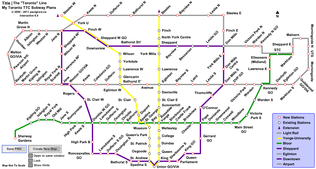
I updated my map a bit,

My_TTC_Subway_Plans_Toronto_Line.png


Added the Morningside/Malvern tracks, and the Malton GO station,

also added a few new features to the Flash map, Right click and rename stations and legend labels, Right click and choose track colour, a Save PNG button, and I upgraded the code from AS2 to AS3 (I hope I got all the bugs out :) )
 
Paul G, you should add the GO lines as well. That would really increase the scale considering that electrification is going to go through. :)
 
Paul G:

Is the Sheppard line and DRL technically the same thing? The purples look REALLY similar.

C
 
Paul G, you should add the GO lines as well. That would really increase the scale considering that electrification is going to go through. :)

yeah, that'd be good, but I don't think they'd fit on my map with all the station names in the way. I guess I could make a transparent gif image of the GO system to overlay over the whole map when clicking a "Show GO" button on the Flash plans.

Paul G:
Is the Sheppard line and DRL technically the same thing? The purples look REALLY similar.
C

Yup, it's one big loop :) I discovered that idea when playing with the interactive Flash map I made. I guess I should change the legend labels a bit on that one.
 
my version

this is my version of the ttc and the RT to be replaced by subway:D
 

Attachments

  • Copy of BT-3478-TorontoHR.jpg
    Copy of BT-3478-TorontoHR.jpg
    100.7 KB · Views: 202
edit

wrong photo thats the subway on the new RT route but here is the map:D
 

Attachments

  • ttc-subway-track-plan-2009 rt rebuilt2.jpg
    ttc-subway-track-plan-2009 rt rebuilt2.jpg
    103.1 KB · Views: 238

Back
Top