News   Jul 09, 2024
 476     1 
News   Jul 09, 2024
 1.3K     2 
News   Jul 09, 2024
 534     0 

Transit Fantasy Maps

Thanks, although I'm starting a map trend to eliminate the connection bubbles, it's sort of redundant, and makes the map look messy and it's sort of common sense that they are already transfer stations.

I disagree. It may be common sense for those who know the system, but for tourists and people who do not frequently use public transit, it is very confusing. Some connections are also hard to spot unless you know exactly where they are. (ie. Kipling TTC to Kipling GO, and Spadina, St. George stations)

I know the system quite well and still find the connections on that map to be confusing. I cant even imagine how confusing it would be to someone who doesn't know it as well as I do.
 
Absolutely beautiful map. Small correction: the F line isn't quite right. It ought to curve towards Yonge, placing:

- Oriole at (south of) Leslie subway station;
- Old Cummer at the place where perpendiculars from Finch and Leslie intersect;
- Langstaff in line with Finch on the Yonge axis and between York and Rutherford on the E-line access;
- RH at the place where perpendiculars from Yonge and the E-line's Maple intersect.

Imagine how much more useful the RH GO line would be if it actually did run near Don Mills/Leslie, rather than veering back toward Yonge? Though its current route is dictated by the location of the existing tracks, heading back toward Yonge creates a large redundancy.

I posted this related fantasy map elsewhere a few months ago, where the blue line represents the extended Yonge subway, and the red line represents a better route for the RH GO line. South of John is existing, while north of John shows the revised route. Today's Langstaff and Richmond Hill stations could still remain operational in rush hour, however the Union to Beaver Creek leg should receive frequent all day service.

This route allows full grade separation all the way to Beaver Creek, provided that a 500m long tunnel is built under Leslie. It operates mostly on existing tracks and on new tracks in non developed parts of the Beaver Creek business park.

RH.jpg
 
Last edited:
^^ I actually really like that idea. But, would it perhaps be easier to just route it under/on/whatever the 404? It could follow the 404 all the way up to Stouffville Road, then rejoin the existing tracks if they want to service Georgina. Otherwise, it could stop all-day regional service near Major Mac, stopping at 7, maybe somewhere in Thornhill, and then at Old Cummer and Oriole. That'd be an amazing rerouting, and makes good use of existing corridors.
If that were so, the Yonge subway should go all the way to Major Mac, using the RH corridor until 16th-ish, and then a short tunneled/raised section to Major Mac.

Oh man, I'm getting a big network connectivity stiffie over that.
 
I think talk of rerouting GO lines is problematic and unrealistic. Widening a ROW is one thing, moving it somewhere there was never a ROW before would be a nightmare.
 
The Richmond Hill GO line needs to stay right where it is to bolster the case for electrifying the corridor such that the Yonge Line doesn't have to be extended into York Region. It's only when a Yonge North LRT line starts costing more than $5-6 billion that a subway is justified.
 
The Richmond Hill GO line needs to stay right where it is to bolster the case for electrifying the corridor such that the Yonge Line doesn't have to be extended into York Region. It's only when a Yonge North LRT line starts costing more than $5-6 billion that a subway is justified.
What? The Richmond Hill line shouldn't be rerouted to an actually useful corridor so that it can attempt to make a Yonge extension redundant? The Yonge extension should happen, and when it does it'd be excellent if the Richmond Hill line got rerouted like this, because it would be pretty well totally redundant with a subway going up to Langstaff.
 
What? The Richmond Hill line shouldn't be rerouted to an actually useful corridor so that it can attempt to make a Yonge extension redundant? The Yonge extension should happen, and when it does it'd be excellent if the Richmond Hill line got rerouted like this, because it would be pretty well totally redundant with a subway going up to Langstaff.

What useful corridor? You do realize that is there is no existing rail corridor parallel to Leslie/404 today til 19th Ave, outside of urban RH, and all infill trackage would have to be built from scratch, right? On prized real estate no less. And to serve what precisely when Beaver Creek is sandwiched 5-7 minutes away from either Richmond Hill or Unionville GO Stns? You do however inconvenience everyone in Thornhill and Richmond Hill that rely on GO Transit to get into Toronto via a reroute.

Electrified GO or Regional Express Rail would be exactly the same as a surface subway line e.g. Spadina north of Eglinton West or between VP and Warden on the Bloor-Danforth. Average speeds however would be even faster because of the wider gaps in-between stations. It's only greed and ignorance that's driving the warrancy for subways to RHC, when the Yonge Line as is is leaving behind passengers on the platforms the way trains are filled by Midtown. The rationale for the subway is just not there when the multi-faceted solution of BRT/LRT/Commuter rail and subway expansion to points other than Yonge/Finch would accomodate everyone with still capacity to spare.
 
I don't think this is a better route, unless the Yonge Subway does get extended up to cover the top of the existing GO RH corridor.

Realistically speaking, all the curves on that route would have trains moving pretty slowly, and I doubt anyone will pay for a curved tunnel under Leslie for bilevel trains. I also wouldn't expect CN to let GO anywhere near their York sub corridor.
 
Giving this another try. Am going to try to find somewhere to upload this in full size. I haven't added the stations for Jane or Don Mills LRTs yet, and have left Waterfront West out.

Work in progress

29goif7.jpg
 
What useful corridor? You do realize that is there is no existing rail corridor parallel to Leslie/404 today til 19th Ave, outside of urban RH, and all infill trackage would have to be built from scratch, right? On prized real estate no less. And to serve what precisely when Beaver Creek is sandwiched 5-7 minutes away from either Richmond Hill or Unionville GO Stns? You do however inconvenience everyone in Thornhill and Richmond Hill that rely on GO Transit to get into Toronto via a reroute.

There are a few things wrong with this argument:

1) New tracks would be built in the hydro corridor, through back lots which currently only have parking lots, and in undeveloped areas near the 404. Prime land perhaps, but not developable land.

2) Having worked there myself, Beaver Creek is at least 15-20 minutes away from the nearest GO station, by existing public transit. This is due to chronic surface congestion in rush hour. I would agree though that in the off peak and because no one is working, 5-7 minutes is realistic by 407 only.

3) You're assuming that people in Thornhill and Richmond Hill actually use the GO line, which they don't in large numbers. The small (by GO standards) parking lot at Langstaff doesn't even fill up - unheard of lack of demand for GO. Of the 8000 daily riders that use GO, maybe 5000 originate in York Region. Those who live in Thornhill could just as easily use a new station at Thornhill Square.

4) Due to the nature of travel in the Yonge corridor, the subway makes sense - as evidenced by the concentration of bus routes that serve Finch, and the much larger parking lot that fills up by 7:30 am. If GO made sense, more people would actually use it considering that it is currently faster than taking the bus to Finch and riding the subway. Might as well end a redundancy of service, and finally provide rapid transit to York's largest office park.
 
The Richmond Hill GO line needs to stay right where it is to bolster the case for electrifying the corridor such that the Yonge Line doesn't have to be extended into York Region.

The RH GO line is not substitutable for the Yonge Line in York Region.

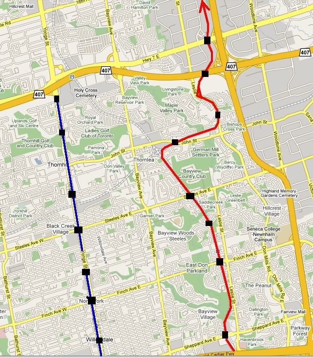
Rather, the RH GO line is most useful for people in York Region going to Willowdale or Scarborough, and -- more importantly -- for people in Willowdale and Scarborough going south.

In any case, the purpose of an express line is not to bolster arguments. It is to move people.

It's only when a Yonge North LRT line starts costing more than $5-6 billion that a subway is justified.

A Yonge North LRT line, which adds transfers and reduces route flexibility without enhancing anyone's trip time, would be a waste of money.

You do however inconvenience everyone in Thornhill and Richmond Hill that rely on GO Transit to get into Toronto via a reroute.

Why would we need to take a GO train into Toronto? We can either walk into Toronto or hop on a short bus ride, depending on location in Thornhill or Richmond Hill.

As to places that the RH GO train actually goes, there is almost noone commuting by GO train to Old Cummer or to Leslie -- and using the RH GO train to get to Union is a long, slow, circuitous route. The subway makes much more sense for most.

It's only greed and ignorance that's driving the warrancy for subways to RHC, when the Yonge Line as is is leaving behind passengers on the platforms the way trains are filled by Midtown. The rationale for the subway is just not there when the multi-faceted solution of BRT/LRT/Commuter rail and subway expansion to points other than Yonge/Finch would accomodate everyone with still capacity to spare.

Part of your second statement is correct, but it doesn't follow your (nasty, and incorrect) first statement. The Yonge line is overcrowded. That's because Toronto's transit system doesn't go to enough places. By way of example, those way out in the east shouldn't need to travel all the way west, to Yonge, just to get south. However, they do. The bus routes that shuttle between Finch station and Scarborough are some of the busiest bus routes in the system. Separately, there's also enormous demand on and around the Yonge corridor itself, which is why the RHC expansion is necessary. The key to alleviating the Yonge line's overcrowdedness is to supplement it with solutions that make sense in locations where they are needed.
 
Last edited:
Giving this another try. Am going to try to find somewhere to upload this in full size. I haven't added the stations for Jane or Don Mills LRTs yet, and have left Waterfront West out.

Work in progress

I really like this one too -- nice to be able to visualize the whole system. Might I suggest adding connection bubbles to places where there are interchanges between GO and TTC trains?

Also, I guess this is out of scope, but I can't help wondering whether it is useful to show dedicated-ROW for VIVA, etc., which would demonstrate things like connectivity between the two arms of the subway.
 
1) New tracks would be built in the hydro corridor, through back lots which currently only have parking lots, and in undeveloped areas near the 404. Prime land perhaps, but not developable land.
What are you thinking about there?
I would have thought that the Toronto Bypass could just be widened to the 404, set as Go tracks. Just past that area, the 404 widens out with quite a large median in the middle, which is probably quite enough room for two tracks. If not, there's plenty of room to move lanes outwards on the highway.
 
Imagine how much more useful the RH GO line would be if it actually did run near Don Mills/Leslie, rather than veering back toward Yonge? Though its current route is dictated by the location of the existing tracks, heading back toward Yonge creates a large redundancy.

While I am not really sure what to make of this proposal, it just occurred to me that one way or another, we will need to be able to get people to and from Pan Am baseball at Richmond Green -- Leslie and Elgin Mills.

It's a lot more likely to be served by special-purpose BRT, though, I'd think.
 

Back
Top