vic
Senior Member
Heck, I'd love it if they opened it up for a walk before traffic gets moved over.I cannot wait to see what riding along this in the top floor of a bilevel is like.
Heck, I'd love it if they opened it up for a walk before traffic gets moved over.I cannot wait to see what riding along this in the top floor of a bilevel is like.
BlogTO cleared the use of my pictures with me. I'm certainly not a huge fan of their content, but this was a story about infrastructure, not a Cotton-Candy-Toilet-Desert-'Experience' or some shit, so I was happy to help. If we here can get regular folks interested in and excited about architecture and infrastructure, it'll have all been a success.
In any case, we've got another two in and the next one is visible down at the Wallace end:
View attachment 416316
I don't know but likely stormwater drainage and signalling/communications cabling.Will the hollow parts of the track beds get filled in? Will they be used for utilities or stormwater drainage?
Might be fun for future urban explorers or DoorsOpen Toronto events? /s
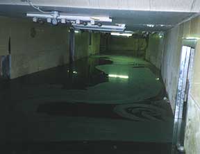
The lower right is where a weird little gated underpass used to go beneath the tracks. It sat abandoned and filled with water up to the 2000s but was filled in before the days of streetview.BlogTO cleared the use of my pictures with me. I'm certainly not a huge fan of their content, but this was a story about infrastructure, not a Cotton-Candy-Toilet-Desert-'Experience' or some shit, so I was happy to help. If we here can get regular folks interested in and excited about architecture and infrastructure, it'll have all been a success.
In any case, we've got another two in and the next one is visible down at the Wallace end:
View attachment 416316
You mean the Paton road underpass? It wasn't filled in until a couple years ago.The lower right is where a weird little gated underpass used to go beneath the tracks. It sat abandoned and filled with water up to the 2000s but was filled in before the days of streetview.
The lower right is where a weird little gated underpass used to go beneath the tracks. It sat abandoned and filled with water up to the 2000s but was filled in before the days of streetview.
Correct, reaper, the underpass connected Paton. In the lower right of my picture is Antler. Oddly enough, it wasn't as filled with detritus as one may think - I stuck my phone in some of the holes in the concrete and it actually looked fairly clean.You mean the Paton road underpass? It wasn't filled in until a couple years ago.
We discussed this earlier in this thread.
 www.google.com
 www.google.com
Bi level? Naw dawg you need to go all out and take the Canadian and ride in the dome car for the great views. Book the trip to Vancouver or just Washago if you’re cheap.I cannot wait to see what riding along this in the top floor of a bilevel is like.
Yes, thanks! It's been a lot of years and I misremembered.You mean the Paton road underpass? It wasn't filled in until a couple years ago.
We discussed this earlier in this thread.
