News   Dec 20, 2024
 1.1K     5 
News   Dec 20, 2024
 870     2 
News   Dec 20, 2024
 1.7K     0 

The Weather

broke off the icicles today. lots of fun breaking them off and hearing them drop below on the deck.
 
Big storm coming

Snow Blower: GTA Braces For What Might Be The Worst One Day Storm In 60 Years

Friday December 14, 2007
CityNews.ca Staff

It happens at least once every winter - a storm so fierce and so serious that you'll remember it for years to come and maybe one day tell your kids how you lived through it. Whether that happens to be the storm that's coming Sunday remains to be seen. But forecasters are calling this a major weather event with potentially serious consequences. Others just call it a good old fashioned nor'easter.

Whatever your name for it - printable or otherwise - the system that started deep in the heart of Texas is expected to strike right in the face of southern Ontario and leave few areas spared. We could get up to 25 centimetres of snow if it tracks the way experts think, potentially making it the biggest such one day snowfall in Ontario for the month of December since 1944.

The weather experts' one sentence prognostication speaks volumes: "25 centimetres in 24 hours." That's more than a centimetre an hour.

Current projections indicate it will start with snow on Saturday night, along with the possibility of some ice pellets or freezing rain, along with gusty and cold winds that will blow it all around and make driving more than just an adventure. There could be whiteouts in spots as the day continues.

The GTA will likely see the snow start just after midnight, with about 5cm in the early morning hours of Sunday. By late afternoon there could be up to 10 to 20 more centimetres on the ground, for a total of as much as 15 to 25 total accumulation.

The city insists it's ready for anything. "We'll be monitoring it, tracking the storm, and ... we'll be preparing for the worst," explains Toronto Transportation's Peter Noehammer. "If it doesn't happen, we'll scale back. We'll be out with our salters to try to keep the roads clear and ice-free.

"If we do get into heavier amounts of snowfall, then we'll be addressing our main roads, the expressway and the arterials to keep them safe with additional salting, and more snow, with plowing. Then we get into the collectors or local streets."

But those 'local streets' could be clogged for a while. The city always does the main routes first and may not get to the side roads for 15-25 hours after the snow stops. "An additional 24 hours is often required to plow difficult areas where snow has not been completely cleared," warns its website.

The city is asking drivers to avoid parking their cars on the streets overnight. It could get in the way of plows, or even worse, the vehicles could be missed altogether if they're buried under a drift. And police are suggesting you keep off the roads if at all possible.

All of this means with just two weekends left before Christmas, you can expect the malls to be packed on Saturday before it all starts, and very long lines to appear in grocery stores as folks stock up for the expected siege.

Those heading out by plane are advised to check with their airlines - this same storm has created chaos in the U.S. and flights are expected to be delayed or cancelled as it hits.

Hard as it is to believe, we're only going to be getting a small part of the worst of it in the GTA. Hamilton and the Niagara region could be digging out from more than 25 centimetres.

All of it arrives with just two weeks to go before Christmas - and one week before winter actually starts.

******

Environment Canada's Official Weather Warnings

Watches
City of Toronto

3:14 PM EST Friday 14 December 2007
Winter storm watch for
City of Toronto continued

..Major winter storm approaching Saturday evening..

This is an alert to the potential development of dangerous winter weather conditions in these regions. Monitor weather conditions..Listen for updated statements.

A major winter storm currently developing in Texas will make its way north towards southwestern Ontario Saturday afternoon. Significant snowfall accumulations over the regions are likely Saturday night through Sunday. It is possible winter storm warnings will have to be issued for some regions due to local snowfall accumulations of 25 centimetres in less than 24 hours. The highest snowfall amounts will likely be in the Hamilton area where embedded lake effect snow will add to the moisture of the system. There will also be significant blowing snow and possibly freezing rain over the regions.

The snow will spread northward and eastwards over most of southern Ontario Saturday night and through Sunday morning. This will make travel on the roads extremely hazardous and travellers are advised to use extreme caution Saturday night and Sunday if they have to use the roads.

Environment Canada is monitoring the situation carefully and will issue the appropriate weather warnings as the storm evolves. Stay tuned for further updates.
 
Though it's completely unrelated to the approaching storm, we're actually getting lake effect snow right now. This would be the first lake effect snow band that I recall affecting Toronto since the winter of 2005-2006.
 
ohh man it's coming!!

cad_None_anim.gif
 
yeah i haven't seen downtown lake-effect snow for a lonnng time.. and it looks totally localized on the downtown core too.

The watch was upgraded to a warning earlier this morning and the writer has a nice touch on dramatics... heh I don't think I've ever read a winter storm warning so dire -- more of a reason to cuddle up and stay in tonight and tomorrow

City of Toronto
10:51 AM EST Saturday 15 December 2007
Winter storm warning for
City of Toronto upgraded from winter storm watch
A near-crippling snow storm with very heavy snow and blowing snow as well as some ice pellets tonight and Sunday.

This is a warning that dangerous winter weather conditions are imminent or occurring in these regions. Monitor weather conditions..Listen for updated statements.

A major winter storm will move into southwestern Ontario with snow beginning this afternoon then spreading northeast into the remainder of southern and eastern Ontario tonight. Copious amounts of snow as well as strong winds causing blowing snow are expected. Freezing rain is also possible near Lake Erie.

Latest analyses indicated that the developing low pressure system has moved over northern Louisiana accompanied by a rapidly expanding area of snow with some freezing precipitation already developing across the upper Ohio Valley towards Lake Erie.

The low will move northeast towards the lower Great Lakes and intensify rapidly into a massive winter storm as it reaches Ohio Sunday morning then tracks across New York state into New England by Sunday night. This storm track will place much of southern and eastern Ontario directly under the brunt of heavy snow. A few claps of thunder along with bursts of very heavy snow are also likely.

Widespread snowfall accumulations of 20 to 30 cm are expected in most areas tonight and Sunday. Some local amounts of 30 to 40 cm are quite possible in a few areas by Sunday night. Parts of eastern Ontario may also receive amounts in excess of 30 cm.

An added complication is the development of a snow squall over the west end of Lake Ontario which is affecting some communities from Oakville to Toronto. Local snow amounts of 5 or more centimetres are possible with this band this afternoon.

Significant blowing snow is expected to be a problem in all regions as strong northeast winds gusting up to 70 or 80 km/h whip up the freshly fallen snow and cause whiteout conditions. Freezing rain is possible especially near Lake Erie for a few hours overnight and Sunday morning as milder air pays a brief visit aloft. Ice pellets are also quite possible generally along and south of a line from Grand Bend to the greater Toronto area to Kingston and Cornwall.

The public should be prepared to change plans accordingly to avoid unnecessary travel during this storm. This massive snow storm has the potential to cause near-paralyzing conditions as any road travel on any unplowed streets may become next to impossible on Sunday. All motorists who must travel are urgently advised to use extreme caution and plan for much extra time to reach their destination.

There is a high degree of certainty with this storm as the concensus of weather model data is virtually unanimously forecasting this event.

Environment Canada continues to closely monitor this situation. The winter storm warnings will likely be expanded northeast across the remainder of the regions this afternoon.
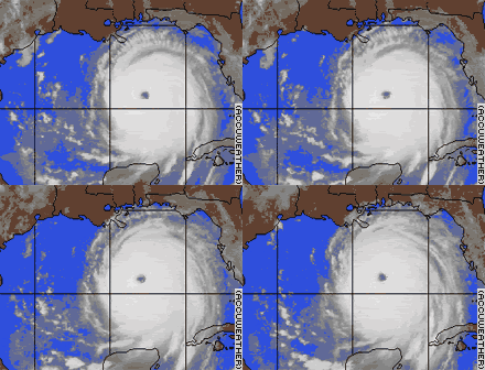
 
Speaking of dramatic, anyone remember this warning posted by the National Weather Service prior to Katrina hitting the Gulf Coast?


storykatanimate1015am1.gif


Urgent Weather Message from NWS New Orleans

WWUS74 KLIX 281550NPWLIXURGENT - WEATHER MESSAGE NATIONAL WEATHER SERVICE NEW ORLEANS LA

311 PM CDT SUN AUG 28 2005

DEVASTATING DAMAGE EXPECTED

HURRICANE KATRINAA MOST POWERFUL HURRICANE WITH UNPRECEDENTED STRENGTH... RIVALING THE INTENSITY OF HURRICANE CAMILLE OF 1969. MOST OF THE AREA WILL BE UNINHABITABLE FOR WEEKS... PERHAPS LONGER. AT LEAST ONE HALF OF WELL CONSTRUCTED HOMES WILL HAVE ROOF AND WALL FAILURE. ALL GABLED ROOFS WILL FAIL... LEAVING THOSE HOMES SEVERELY DAMAGED OR DESTROYED. THE MAJORITY OF INDUSTRIAL BUILDINGS WILL BECOME NON FUNCTIONAL. PARTIAL TO COMPLETE WALL AND ROOF FAILURE IS EXPECTED. ALL WOOD FRAMED LOW RISING APARTMENT BUILDINGS WILL BE DESTROYED.

CONCRETE BLOCK LOW RISE APARTMENTS WILL SUSTAIN MAJOR DAMAGE... INCLUDING SOME WALL AND ROOF FAILURE. HIGH RISE OFFICE AND APARTMENT BUILDINGS WILL SWAY DANGEROUSLY... A FEW TO THE POINT OF TOTAL COLLAPSE. ALL WINDOWS WILL BLOW OUT. AIRBORNE DEBRIS WILL BE WIDESPREAD... AND MAY INCLUDE HEAVY ITEMS SUCH AS HOUSEHOLD APPLIANCES AND EVEN LIGHT VEHICLES. SPORT UTILITY VEHICLES AND LIGHT TRUCKS WILL BE MOVED. THE BLOWN DEBRIS WILL CREATE ADDITIONAL DESTRUCTION. PERSONS...PETS... AND LIVESTOCK EXPOSED TO THE WINDS WILL FACE CERTAIN DEATH IF STRUCK. POWER OUTAGES WILL LAST FOR WEEKS... AS MOST POWER POLES WILL BE DOWN AND TRANSFORMERS DESTROYED. WATER SHORTAGES WILL MAKE HUMAN SUFFERING INCREDIBLE BY MODERN STANDARDS. THE VAST MAJORITY OF NATIVE TREES WILL BE SNAPPED OR UPROOTED. ONLY THE HEARTIEST WILL REMAIN STANDING... BUT BE TOTALLY DEFOLIATED. FEWCROPS WILL REMAIN. LIVESTOCK LEFT EXPOSED TO THE WINDS WILL BE KILLED. AN INLAND HURRICANE WIND WARNING IS ISSUED WHEN SUSTAINED WINDS NEARHURRICANE FORCE... OR FREQUENT GUSTS AT OR ABOVE HURRICANE FORCE.. ARE CERTAIN WITHIN THE NEXT 12 TO 24 HOURS. ONCE TROPICAL STORM AND HURRICANE FORCE WINDS ONSET... DO NOT VENTURE OUTSIDE

LAZ038-040-050-056>070-282100-ASSUMPTION-LIVINGSTON-LOWER JEFFERSON-LOWER LAFOURCHE-LOWER PLAQUEMINES-LOWER ST. BERNARD-LOWER TERREBONNE-ORLEANS-ST. CHARLES-ST. JAMES-ST. JOHN THE BAPTIST-ST. TAMMANY-TANGIPAHOA-UPPER JEFFERSON-UPPER LAFOURCHE-UPPER PLAQUEMINES-UPPER ST. BERNARD-UPPER TERREBONNE-311 AM CDT SUN AUG 28 2005
 
the storm seems pretty paralyzing to me right now. i definitely don't wan tto get out of bed right now... i can hardly even see across the street right now the snow is so dense.
 
YES!

going outside to take some pics of downtown. this might get messy.
 
the storm seems pretty paralyzing to me right now. i definitely don't wan tto get out of bed right now... i can hardly even see across the street right now the snow is so dense.

yes, it's rather differently ableing weather out there. lots of cars on the highway are becoming differently able with the snow.

;)
 
I went out this morning at 11 and shovelled snow for almost an hour. Then I did another 20 minutes just before heading off to the ROM at 2 pm. Later tonight I'll be at it again.

Wow! 25 cms!

I can't remember the last time I had to deal with 25 cms. I'd almost forgotten how ...
 
It's like riding a bicycle, once you've dealt with 25cm you never forget how...
 
I'm hoping, one wintery morning, to open my front door and see 30 or 35 cms waiting for me out there. Going mano-a-mano with 30 or 35 cms has always been a sort of Holy Grail for me.
 

Back
Top